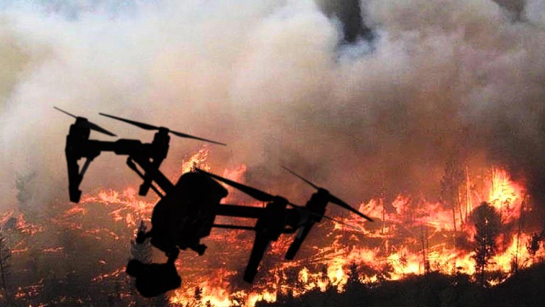
How drones are helping fight California's wildfires
Science
[SOUND] It's summer in California.
That means fire and wide-spread devastation.
hundreds of square miles of it.
[SOUND] Drones are a new weapon to help fight the flame.
Instead of sending ground crews into dangerous conditions or using helicopters that can't fly in heavy smoke, drones are taking photos and sending wide videos of fires and their aftermath.
Menlo Park Fire in California, in the heart of Silicon Valley, is one of the mations's first fire departments to use drones.
They're regularly called on to help fight California's long wildfire season.
Drones also create detailed 360 degree aerial images to map burned out areas after the fires pass through.
With the drone, Get down near the same level of capabilities without putting a person in a aircraft which is incredibly expensive.
The drone's very low cost relative what you get back.
Cameras on the drone give pilots a bird's eye view so crews can see things like the hotest part of the fire Whether or not a fire has crossed a containment line or if people are in danger.
[BLANK_AUDIO]
In this training demo pilots use a thermal camera to see people through smoke inside a five story building.
I'm gonna switch over to thermal view.
And suddenly now we can see that we have at least two individuals inside This room.
Drones can also measure wind speed and direction, so crews can predict what a fire might do next.
Our pilots when they're on duty have these DJI Mavic with them, and this one's wrapped, so it stands out as a fire department aircrafts, and then we have you know chargers, spare batteries that we keep with it and this is what's on our engines on a daily basis.
[MUSIC]
Larger drones are also a key part of the arsenal.
They can fly for up to 40 minutes, double the time of many smaller drones.
As well as cameras, they can carry other items like an LED light to will illuminate a scene at night.
Some of our drones can carry 10 pounds or more So the ability to fly things like a life jacket, a radio, a space blanket that could actually make a difference seconds matter.
But flying a drone and working out what's happening on screen is isn't easy especially if you're in a high stress situation like a fire.
With a free app called First Response from Edgybees, details like road names, wind speed, and crew locations are overlaid on the drone image, so pilots don't have to cross-reference another map.
The California Air National Guard is using the MQ-9 Reaper this summer.
It's a military drone that flys for hours to identify where the fire has jumped containment lines and houses in the fire's path.
Pull.
The government has contracted four companies to fly fixed wing drones to fight fires on federal land.
This brings up resources like helicopters for water drills.
And fire crews aren't the only ones flying drones to fight wildfires.
Some utilities like San Diego Gas and Electric are inspecting the power grid from the sky with drones.
These third-party drones have lidar on board similar to the technology used in self driving cars.
And generate 3D maps of potential issues like damaged power poles and lines.
In the future, drones may truly be the first responders.
By having a drone automatically launch, go line-of-sight to a call, send information back, we can actually evaluate the scene and decide, do we need to escalate our response, de-escalate our response?
While 180 US fire departments are beginning to use drones Widespread adoption is still up in the air.
They're still working out all the rules with the FAA on how this all works.
But we're happy that in this area, we're not being ignored.
Having another set of eyes in the sky is an invaluable tool to help win the battle against wildfires, and to save lives.
[SOUND]