Road test: AT&T Navigator GPS iPhone application
AT&T Navigator offer text-to-speech, real-time traffic updates, and updated maps and POIs, however, due to the sketchy coverage of AT&T's data signal, it's not a dependable navigator yet, especially in big cities.


So far I've tested four flat-fee GPS applications for the iPhone with built-in offline maps: Navigon, iGo My Way, TomTom, and CoPilot Live. They all have pros and cons, but they share a few common shortcomings: a lack of real-time traffic, no support for text-to-speech (except for Navigon with its recent update), and outdated maps.
I've just finished testing a GPS navigation app that offers all of those previously unavailable features: the AT&T Navigator (version 1.2i.5). The catch? It doesn't have built-in maps (meaning you will need a working data connection to download the maps in real time) and it requires a monthly subscription of $10. The app itself is free.
This is one of the first GPS navigation applications made for the iPhone. It's actually a product by TeleNav and is also available for other cell carriers, including Sprint and Alltel.
Unlike the other aforementioned apps that take an hour or so to download using Wi-Fi, the AT&T Navigator has no built-in maps and therefore is a snap to install on the iPhone, even via a 3G or Edge connection. This makes it a perfect quick add-on when you suddenly need a GPS navigator.
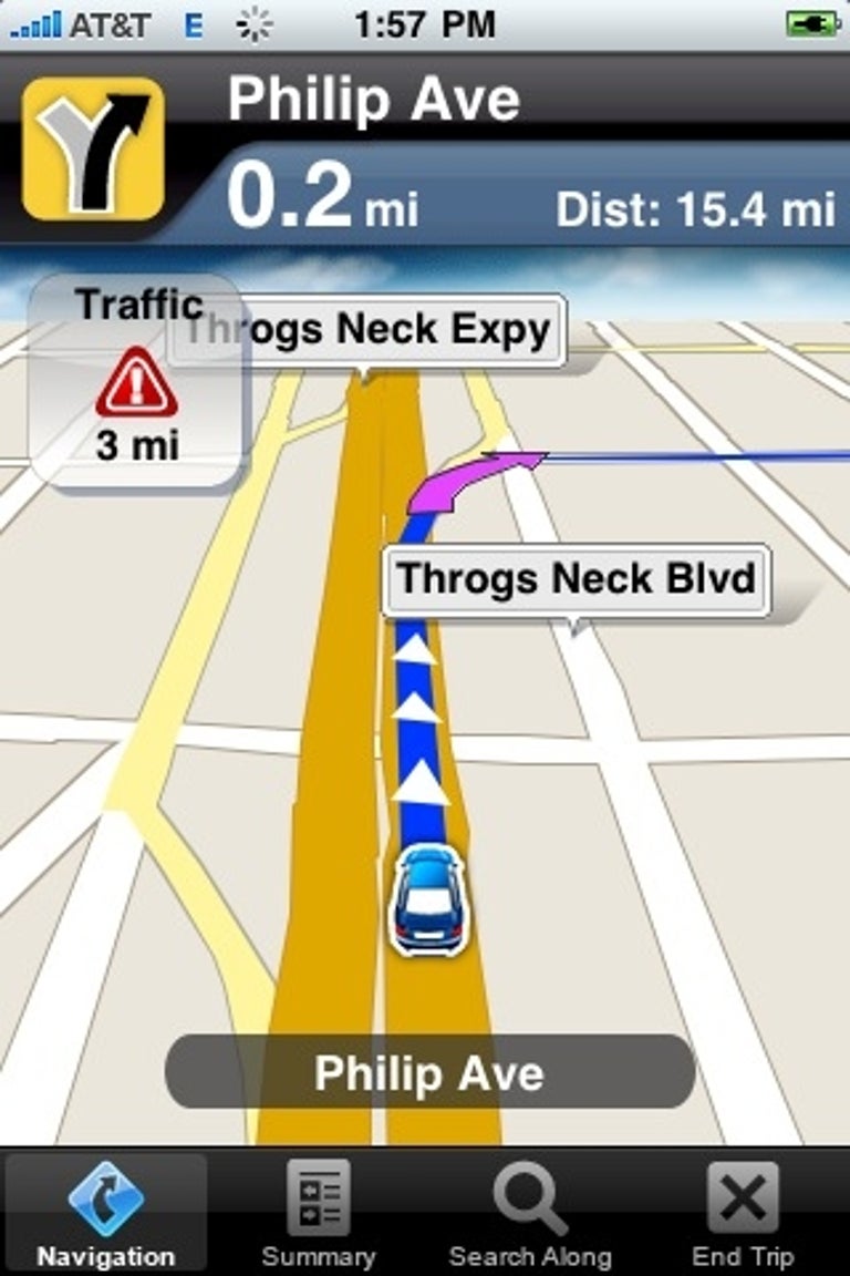
The app also launches very quickly, taking just a second or two on my iPhone 3GS. When it can (more on this later), it also picks up GPS signals very fast. After about a week of use, I can say I really like the real-time traffic updates--which warn you both onscreen and audibly--and the text-to-speech features. This is especially helpful when you are in a unfamiliar town.
However, I found out that the traffic updates are available mostly for freeways only, unlike Google Maps, which offer them all the way down to street level for major cities.
The text-to-speech is especially important, as it somewhat makes up for AT&T Navigator's lack of lane assist, a feature most other GPS apps I've tested offer. AT&T Navigator doesn't explicitly show you on the map view what lane to take in case of multiple exists or freeway merging so hearing the name of the street or exit read aloud is vital.

The app is well integrated with the iPhone's contact list, however, it may take some time (up to 10 seconds or so) to read addresses, because it has to communicate with its back-end server to find out the address and routing in real-time.
This communication is the source of many problems. First of all, this means performance is at the mercy of AT&T's data signal, which--let's be honest--is sketchy at best. When there's no data signal, the map view just freezes and the car icon (representing your current location) just sticks in one place. There's no indication of what's going on either on the screen or via audio. This happened three times during a short trip around the Bronx to JFK airport.
The second issue with the app is that it seems basically unable to get a GPS signal in the densest parts of big cities--in my case, both in Manhattan and in downtown San Francisco--presumably due to the skyscrapers. I found this interesting, because although the app couldn't get GPS signal for routing, it was able to display my correct location (via the dot, similar to that of Google Maps) on its map.

Now here's the dilemma: the app has no problem picking up a GPS signal in open space, small cities, or out in the suburbs, but it's the big cities where you have better coverage of data signals, especially 3G. So it seems there's no best place for the app. Fortunately, the app works relatively well even where 3G is unavailable. Where it isn't, everything, including routing, takes a little longer to happen and if you drive too fast, the map view might not be updated quickly enough to show you everything.
To make up for this, the AT&T's maps and POIs are very up-to-date. (During the construction closure of the Bay Bridge over the Labor Day weekend, TeleNav even made the routing of the app automatically exclude the bridge.) You can also dial up a point of interest's (POI's) phone number just by tapping on it.
All in all, though I really like the text-to-speech feature, updated maps and POIs, and real-time traffic, until AT&T's data coverage gets better, the AT&T Navigator is not an option you can depend on. For now, it's a much better idea--and, in the long run, cheaper--to go with an app with built-in maps, such as Navigon or TomTom.