Odyssey Orbiter nears Martian longevity record (photos)
Since entering Mars' orbit on October 24, 2001, NASA's Mars Odyssey orbiter has made countless contributions to understanding the Red Planet.
James Martin
James Martin is the Managing Editor of Photography at CNET.
His photos capture technology's impact on society - from the widening wealth gap in San Francisco, to the European refugee crisis and Rwanda's efforts to improve health care.
From the technology pioneers of Google and Facebook, photographing Apple's Steve Jobs and Tim Cook, Facebook's Mark Zuckerberg and Google's Sundar Pichai, to the most groundbreaking launches at Apple and NASA, his is a dream job for any documentary photography and journalist with a love for technology.
Exhibited widely, syndicated and reprinted thousands of times over the years, James follows the people and places behind the technology changing our world, bringing their stories and ideas to life.
NASA's Mars Odyssey orbiter will today mark its 3,340th day making observations of the Red Planet, longer than any other spacecraft in history.
After entering Mars' orbit on October 24, 2001, the spacecraft has made countless contributions to space exploration.
In early 2002, Odyssey detected hydrogen just below the surface along the planet's high-latitude regions.
Hypothesizing that the hydrogen is in frozen water, NASA sent the Phoenix missions to confirm the suspicion, a fact which was authenticated in 2008.
Further research contributions included the spacecraft assessing the possibility of human occupation of Mars by taking readings on radiation levels at potentially habitable sites to aid in the planning of future maned missions.
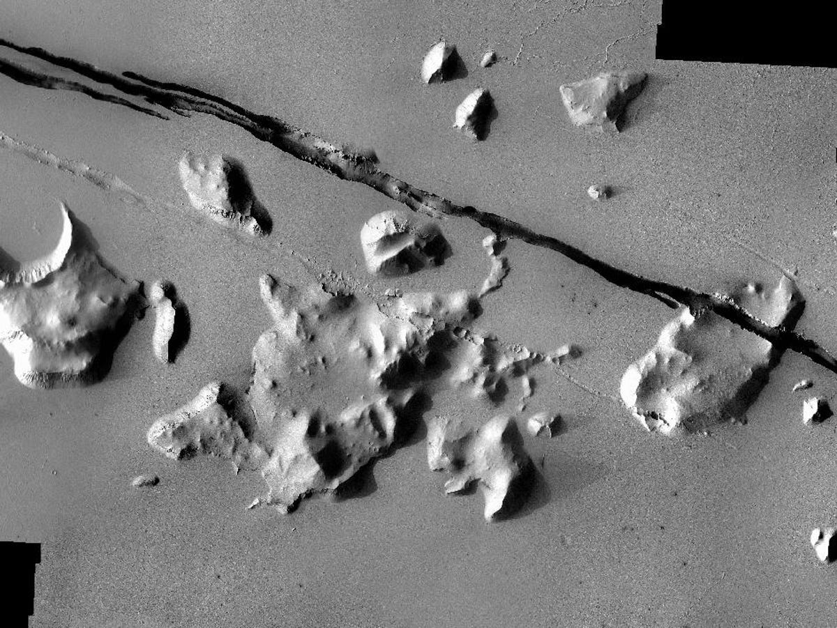
Here, formation of the nearby Elysium Volcanic field has created fault lines on Mars, and may have contributed to the release of pressurized underground water, which the Odyssey confirmed.
2 of 13 NASA/JPL-Caltech/ASU
Evidence of flooding
After completing its primary mission objectives in 2004, the orbiter's Thermal Emission Imaging System (THEMIS), operated by the University of Arizona, began to photograph the planet.
"The extra years have allowed us to build up the highest-resolution maps covering virtually the entire planet," said Odyssey Project Scientist Jeffrey Plaut of NASA's Jet Propulsion Laboratory, in Pasadena, Calif.
In search for evidence of water on Mars, Odyssey captured these images which scientists believe indicates a history of flood waters with peak volumes many times the flow of today's Mississippi River.
The teardrop shaped land trailing off from the craters shows how the raised rims of the impact craters diverted raging waters, protecting the nearby ground from the erosion that formed the pennant-like shapes of remaining soil.
3 of 13 NASA/JPL-Caltech/ASU
Udzha Crater
Polar regions became a primary focus for the orbiter, and researchers benefited from the ability to monitor seasonal changes on Mars year-to-year, observing cycles of carbon-dioxide freezing out of the atmosphere in polar regions during each hemisphere's winter.
Over thousands of year since it was created, fine Martian soils, blowing dust, and layers of ice have encroached upon the Udzha Crater, nearly burying the 28-mile-wide feature.
As the topography surrounding Udzha has been built up, only the outer rim of crater is visible, peeking through the years of polar deposits near the edge of the northern polar cap.
4 of 13 NASA/JPL-Caltech/ASU
Canyons known as Noctis Labyrinthus
Looking west, this composite of images was taken during the period from April 2003 to September 2005.
The series of steep canyons lies in a region of Mars between the Valles Marineris and the Tharsis upland in the Phoenicis Lacus quadrangle known as Noctis Labyrinthus.
The formations were created during a long period of geologic upheaval when tectonic activity collapsed unstable ground and released subsurface water and ice, creating the deep canyons and steep ravines.
Odyssey has also assisted NASA's Mars Exploration Rovers, Spirit and Opportunity.
Odyssey was used as the rover's primary communication relay for transmission to Earth. Nearly all the science data from the rovers and NASA's Phoenix Mars Lander has reached Earth via Odyssey relay.
5 of 13 NASA/JPL-Caltech/ASU
Noctis Labyrinthus maze of canyons
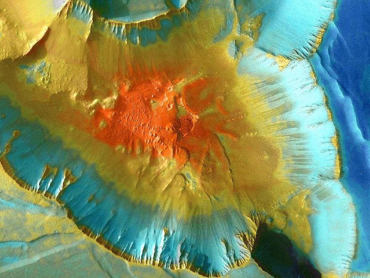
Another grand Martian canyon with an astounding depth of more than 13,000 feet, this image shows one junction in Noctis Labyrinthus, a vast region where intertwined mazes of seemingly endless canyons intersect.
This false-color mosaic gives a sense of grandeur, with the cooler, upper sea level surfaces shown in blue, while the warmer, rockier canyon floor, more than 13,000 feet below is colored red.
6 of 13 NASA/JPL-Caltech/ASU
Eastern Arabia region of Mars
This varied image shows the difference in terrain and soil types of the eastern Arabia region of Mars.
Surrounding an enormous 75-mile-wide crater, the Thermal Emission Imaging System instrument on NASA's Mars Odyssey orbiter depicts fine surface sands with a bluish tint, rock outcroppings and harder sediments in red.
7 of 13 NASA/JPL-Caltech/ASU
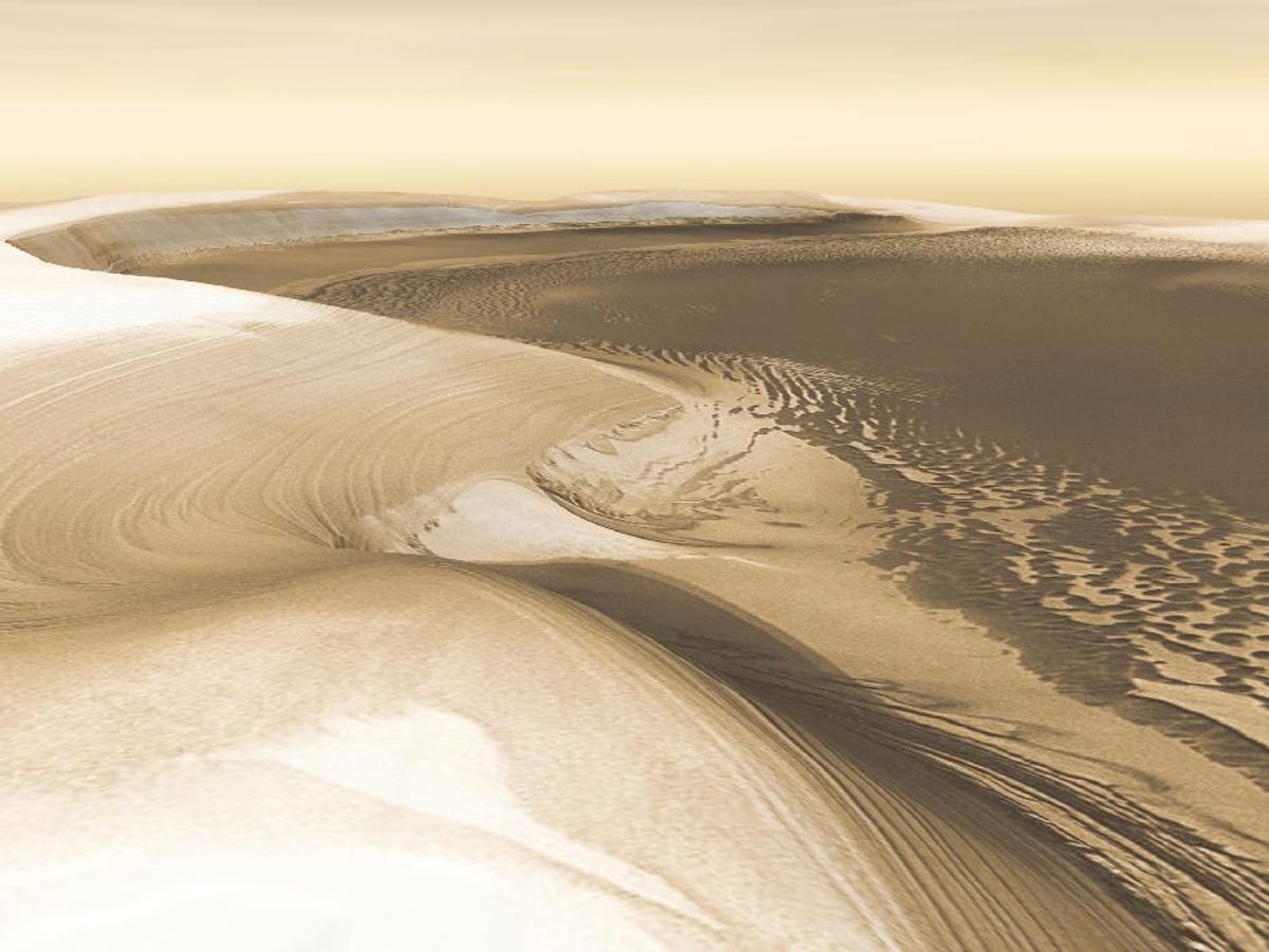
A long, flat-floored valley surrounded with 4,600-foot walls known as Chasma Boreale was formed by slowly moving glacial icecaps carving out the Martian geography.
8 of 13 NASA/JPL-Caltech/ASU
Double impact crater
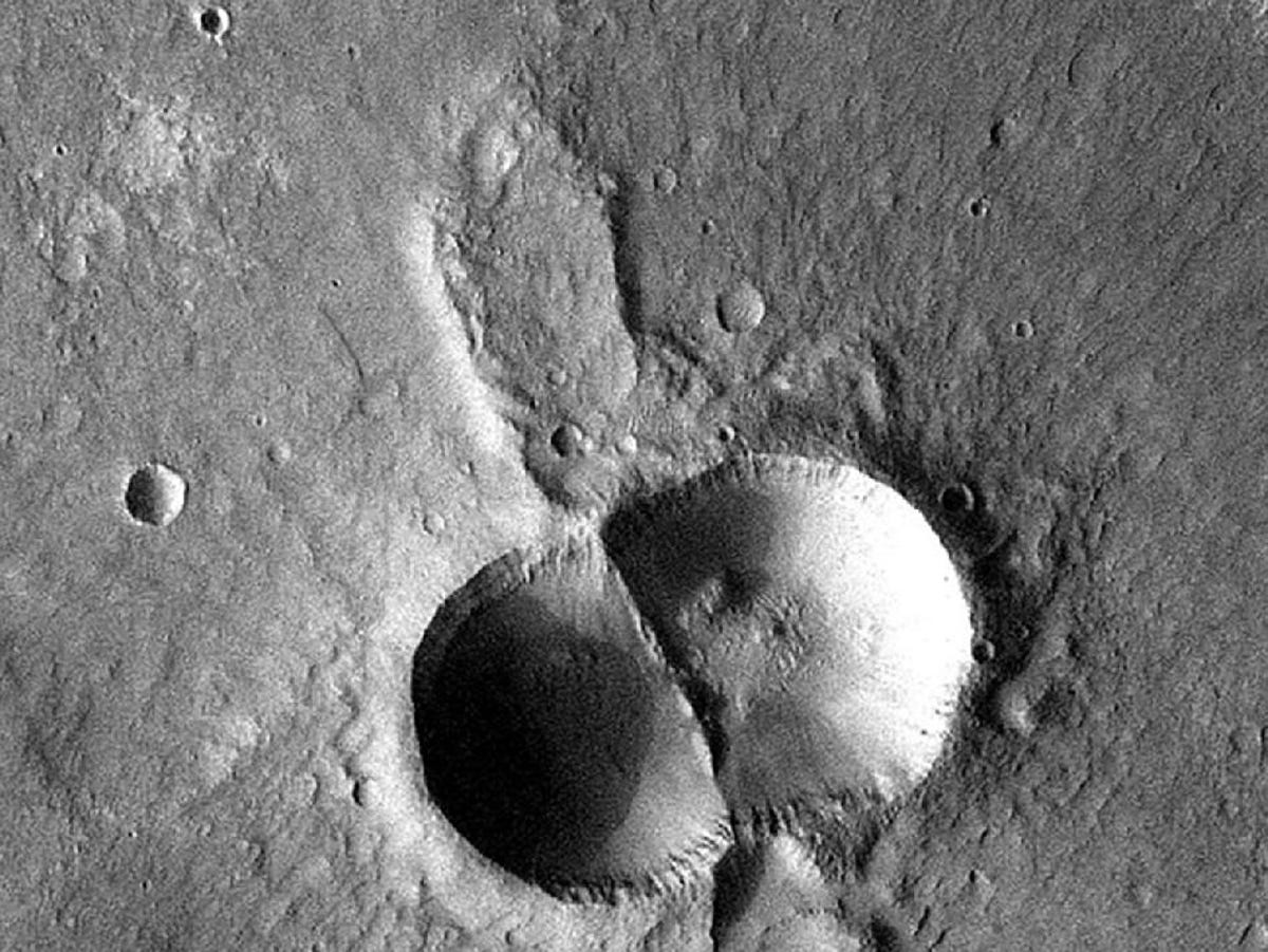
This oddly shaped four mile wide double impact crater is reminiscent of a dividing cell, but the feature is actually the result of a meteorite breaking in two shortly before hitting the ground.
After breaking apart in the Martian atmosphere, the typical concave shape of a single impact crater becomes doubled when the two circular regions intersect, creating a tall, straight wall separating the two indentations.
9 of 13 NASA/JPL-Caltech/ASU
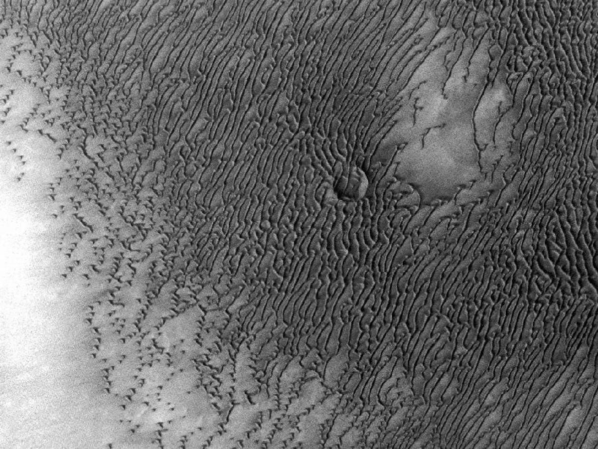
Ancient impact craters
Martian sand dunes, pushed slowly across the surface by Martian winds have nearly engulfed an ancient impact crater along the northern polar cap, leaving these beautiful scaled patterns behind.
10 of 13 NASA/JPL-Caltech/ASU
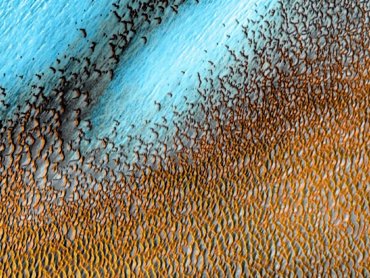
Thermal Emission Imaging System instrument
A false color image created with Odyssey's Thermal Emission Imaging System instrument--spanning an area the size of Texas, with cooler temperatures depicted in blues and warmer temperatures shown in yellows--shows the intricate patterns created by sand dunes surrounding the northern polar cap of Mars.
11 of 13 NASA/JPL-Caltech/ASU
The enormous Bacolor Crater
The enormous Bacolor Crater, measuring nearly 12 miles wide, is a stunning example of an impact feature embedded on the Martian surface.
12 of 13 NASA/JPL-Caltech/ASU
Sand dunes near the northern ice cap
Taken in April 2006 by the Thermal Emission Imaging System instrument on NASA's Mars Odyssey orbiter, this abstract image shows patterns created by sand dunes near the northern ice cap of Mars.
13 of 13 NASA/JPL-Caltech/ASU
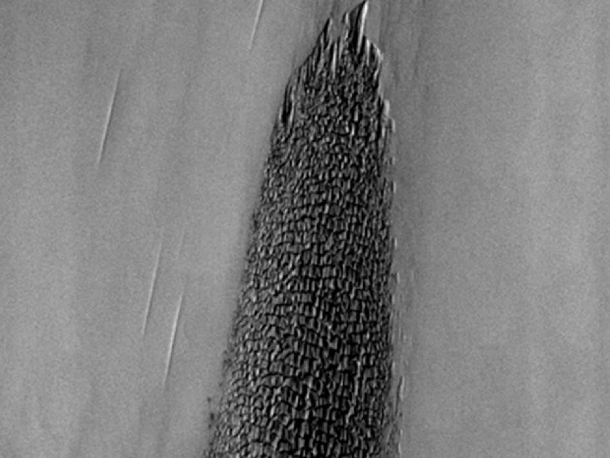
Dunes
Dark sand dunes, blown to steep peaks and whispy valleys creep across the floor of the Bunge Crater on Mars.