NASA's red alert on fire risk and climate change (pictures)
A newly released animation from the space agency, based on data gathered from fire-spotting satellites, suggests that a warming planet means more "fire weather."


NASA's red alert on fire risk and climate change
"Fire seasons are getting longer, western regions are getting drier, and more people are living closer to fire-prone areas."
That's the word from Don Smurthwaite, spokesperson with the National Interagency Fire Center in Boise, Idaho. Smurthwaite is quoted in a NASA article published this week that accompanies a newly released animation which alarmingly shows how the risk of fire may increase in North America as the climate warms up and the environment becomes ever drier.
Read on for more about the animation and NASA's efforts to monitor fires around the globe.
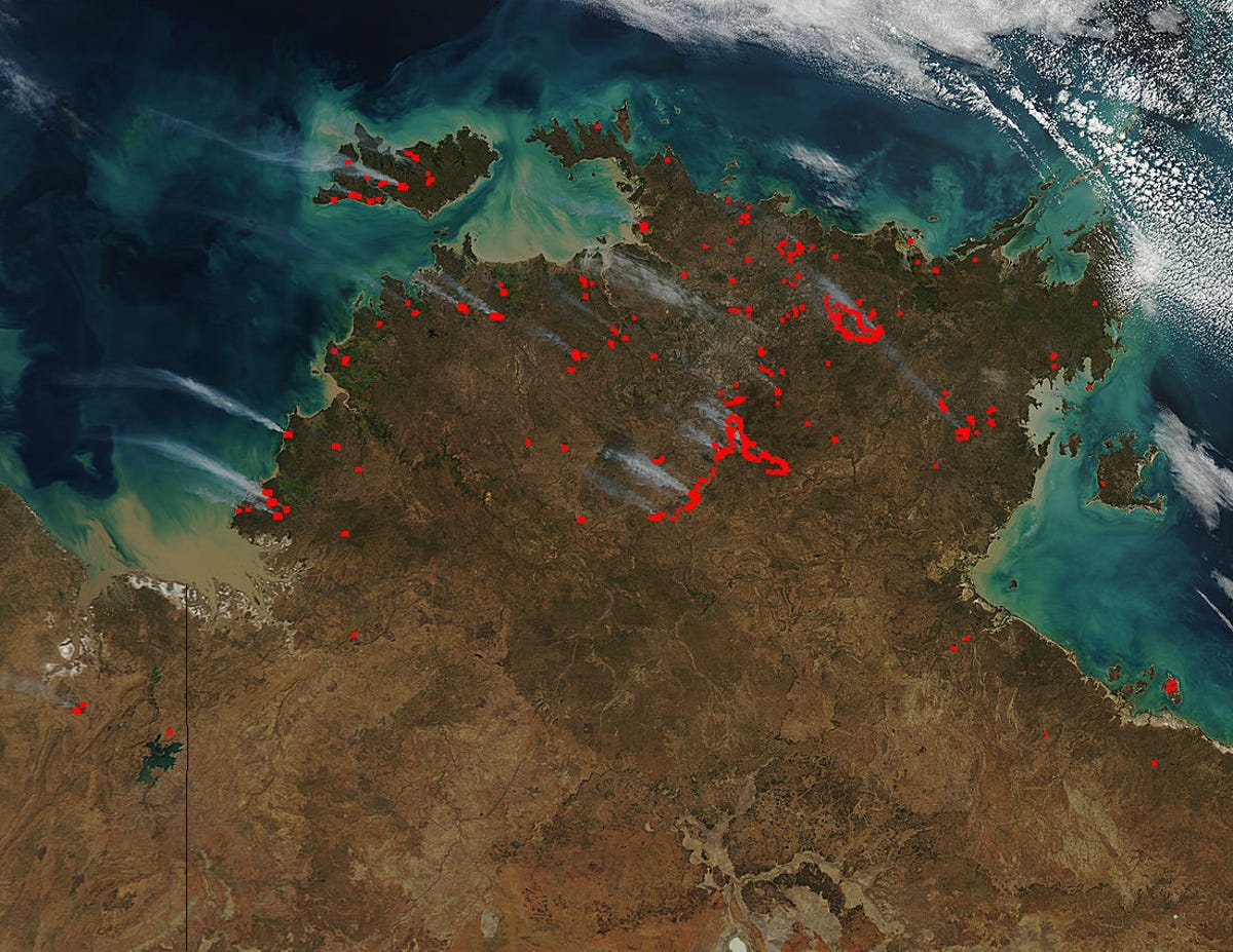
Fires down under
The data behind the newly released NASA animation comes in part from observations made by two of NASA's flagship Earth-observing satellites, Terra and Aqua, which for more than 10 years now have been tapping an instrument called MODIS -- the Moderate Resolution Imaging Spectroradiometer -- to scan our planet for fires.
The two craft orbit the planet once every hour and a half or so and can text forest managers around the world with the coordinates of active fires, so that the appropriate agencies can respond as needed. The MODIS data also allows for the mapping of potential trends. NASA says MODIS has "revolutionized what scientists know about fire’s role in land cover change, ecosystem processes, and the global carbon cycle by allowing researchers to map characteristics of the global distribution of fires in remarkable detail."
The above image of fires in northern Australia was captured by Aqua and MODIS on July 23.
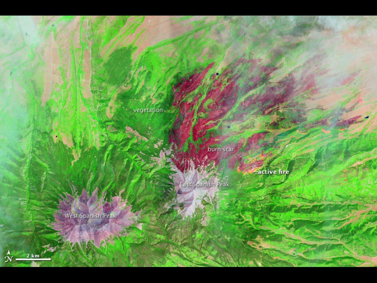
Burn scar
Other spacecraft and tools are involved as well, including VIIRS (the Visible Infrared Imaging Radiometer Suite), OMPS (the Ozone Mapper Profiler Suite), and Landsat satellites jointly operated by NASA and the U.S. Geological Survey.
The Landsat satellites are tapped by a USGS and U.S. Forest Service project called Landfire (Landscape Fire and Resources Management Planning Tools), which NASA says was begun a decade ago "after an intense U.S. wildfire season highlighted the need for unbiased information to guide decision makers as they allocate [fire-fighting] resources."
The above false-color image was captured by Landsat 8 on June 22. It shows the East Peak fire burning in southern Colorado near Trinidad. Burned areas appear dark red, while actively burning areas look orange. Dark green areas are forests; light green areas are grasslands.
All this data is being put to use to understand what effect climate change is having on wildfires in the U.S.
And judging from NASA's projections, the news isn't necessarily heartening.
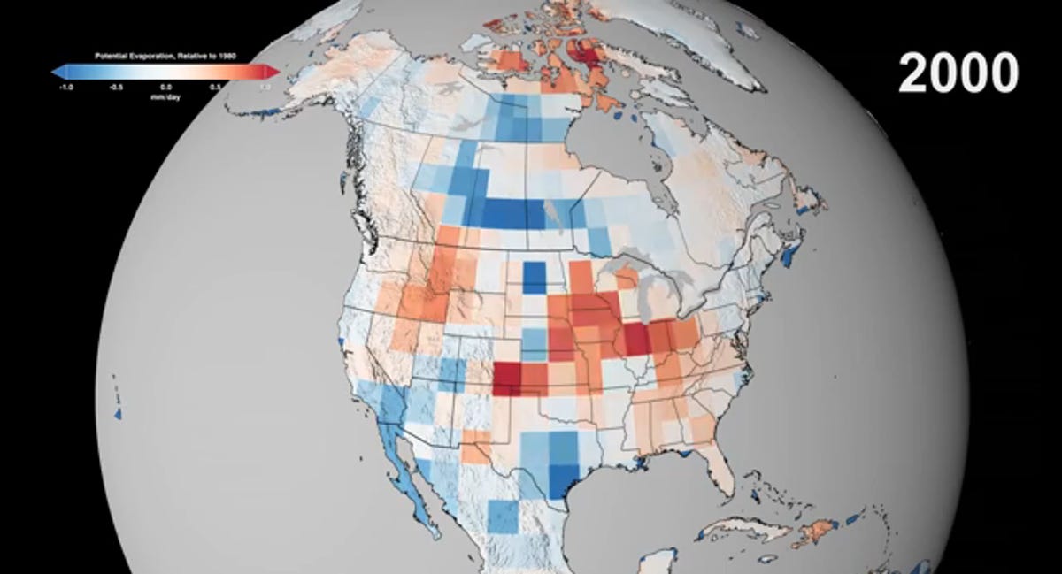
A little red
Before we get to the animation itself -- which shocks with its quickly blooming red areas -- let's look at a few frames. The animation combines the results of multiple climate models to show the projected increase in "potential evaporation" through 2100, relative to 1980. What's that mean? Read on...
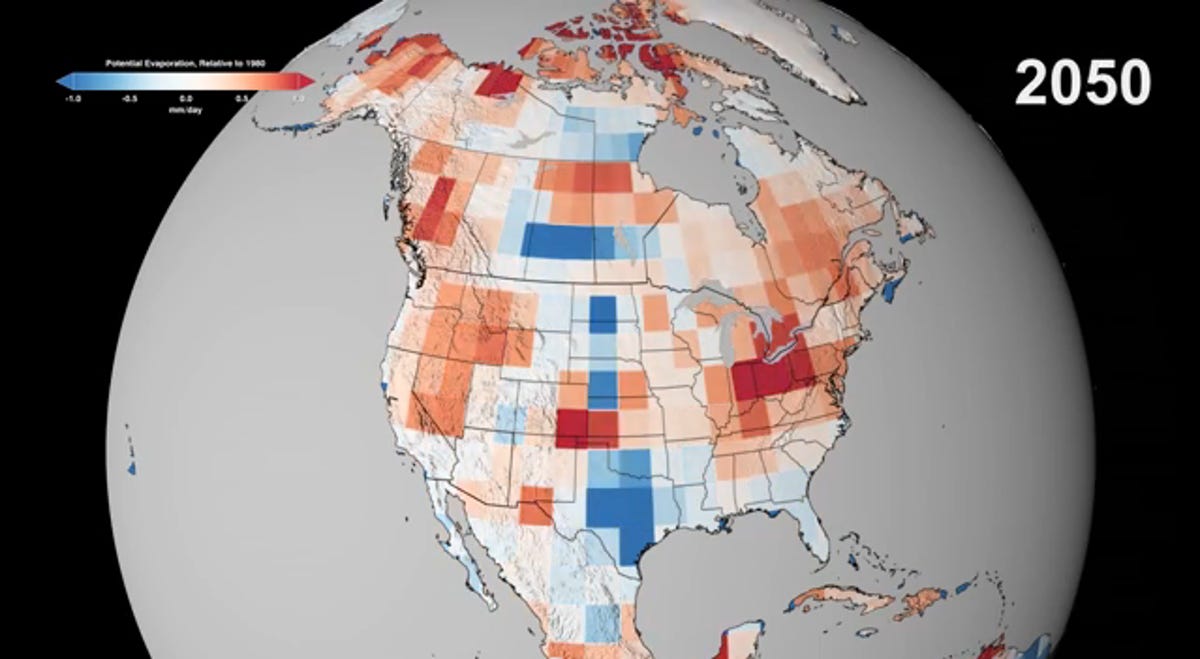
A little more red
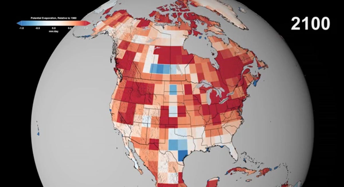
A lot of red
NASA says, "An average increase of 1 mm/day over the whole year is a big change, one we can put in specific terms: We consider a 1 mm/day increase in [potential evaporation] to be an 'Extreme' event for fires, something like 2012 in Colorado. By these projections, fire years like 2012 would be the new normal in regions like the western U.S. by the end of the 21st century."
The new normal? That's unsettling, given that 2012 was one of the worst in half a century in terms of wildfires. In other words, all those red areas above, which weren't there two slides ago, suggest a lot more fires, a lot more burned houses, potentially a lot more casualties, and a lot of money spent on fire fighting and relief efforts.
Watching the red areas grow makes this point in frightening fashion. Here's the animation:
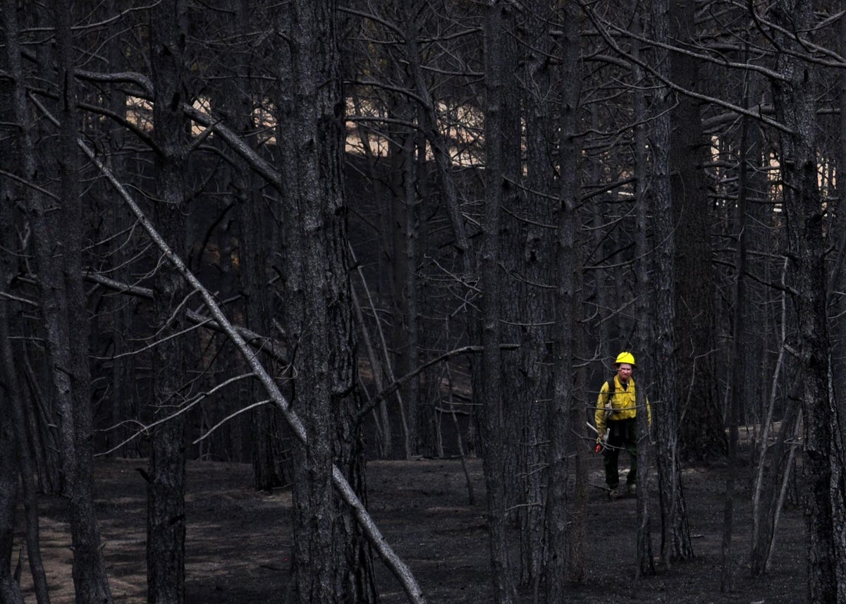
Black forest
"How will fire frequency change in a world where the climate is getting warmer? Where dry places will get even less rain?" NASA asks in another video released this week. "Climate projections show that the drying trend in the United States will continue. There will be a greater risk of fire by the end of the 21st century in places that aren't prone to burning now, like the Great Plains and upper Midwest…That means more homes at risk, more federal dollars spent on rebuilding, a greater risk to the nation's food supply."
What's the answer? The space agency suggests that if humanity can somehow negotiate the financial, political, and other obstacles that lie in the way, we can slow the pace of the spread of "fire weather."
"If we reduce our greenhouse gas emissions, can we mitigate these risks?" NASA asks. "Under a low-carbon scenario, temperatures rise by 4.5 degrees. But under a high-carbon scenario, temperatures rise by 8 degrees. Either way means more fires, but…higher temperatures mean more burn scars."
Here's that video:
More Galleries

My Favorite Shots From the Galaxy S24 Ultra's Camera
20 Photos
Honor's Magic V2 Foldable Is Lighter Than Samsung's Galaxy S24 Ultra
10 Photos
The Samsung Galaxy S24 and S24 Plus Looks Sweet in Aluminum
23 Photos
Samsung's Galaxy S24 Ultra Now Has a Titanium Design
23 Photos
I Took 600+ Photos With the iPhone 15 Pro and Pro Max. Look at My Favorites
34 Photos
