 Why You Can Trust CNET
 Eye in the sky: How satellite photos help us learn about our world
Here's a behind-the-scenes look at the ways a satellite imaging company gives us a new perspective on the planet and makes the internet better.


Photos... from... spaaaaaaaace.
I'm going to assume you've checked out satellite photos of your house. Why wouldn't you, right? Depending where you live, the image resolution might be high enough for you to make out the car in your driveway.
DigitalGlobe is one of the main purveyors of satellite photos, pictures taken with telescopes in orbit and beamed down from space. You can find its images on Google Maps and Google Earth, among others. The company's Instagram account shows incredible slices of the world. Its images also appear in other places including the super popular Daily Overview.
The new WorldView-4 satellite, launched at the end of 2016, will give DigitalGlobe even more coverage. It'll also have the potential to deliver even more incredible images. Here's a behind-the-scenes look at how it works.
As good as satellites are allowed to get
Satellite photography isn't new. Basically since we starting lobbing stuff into orbit, people figured out how to take pictures from there. It wasn't until 1992 that it became legal for private companies to get into the satellite photo business. That's when WorldView Imaging Corporation was founded, which today is DigitalGlobe.
As the technology improved and the regulations decreased, higher and higher resolutions were possible. Today the highest resolution available for consumer use is 31 centimeters per pixel. Higher resolutions are restricted to government satellites. If that's what we get to see, how much better do you think the government stuff is? Think they can identify faces or license plates from orbit yet?
Not all the "satellite" photos you see online are actually, well, satellite photos. In some cases, they're high-resolution photographs taken from planes. So the really detailed stuff might not have been taken from space. Kind of a bummer, that, right? There are limits to aerial photography, though, hence the need for satellites.
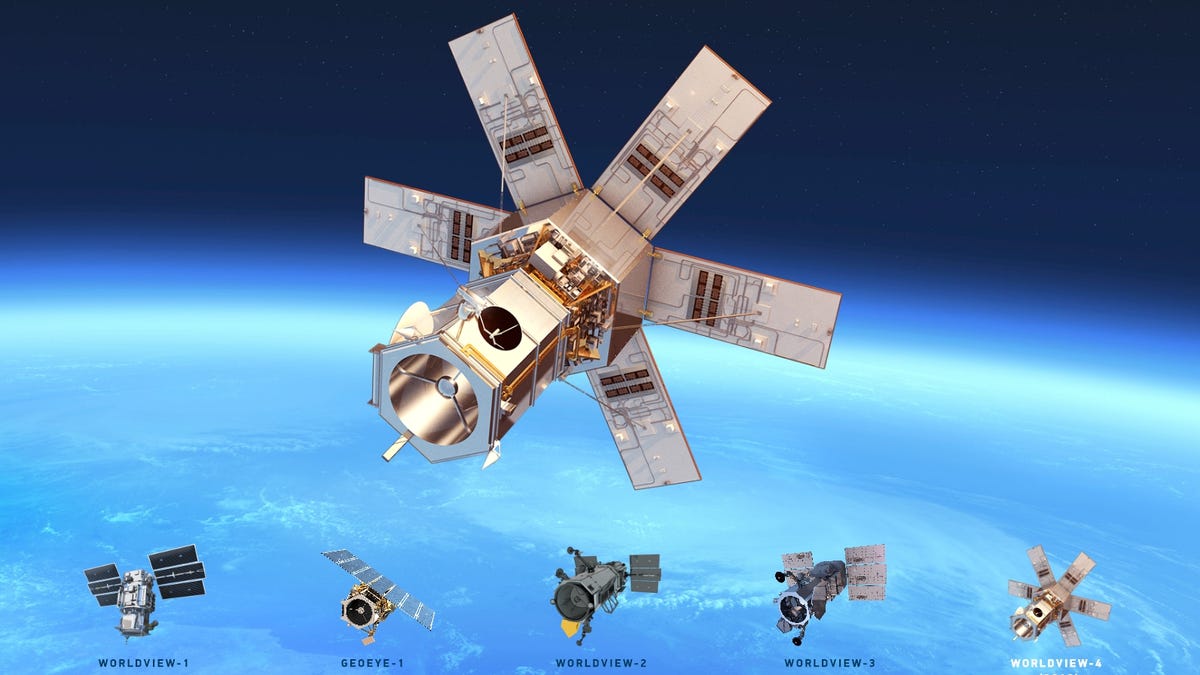
A view from the WorldView-4
Last November, DigitalGlobe's WorldView-4 satellite launched into orbit from Vandenberg AFB on top of an Atlas V rocket built by United Launch Alliance. It orbits at an average distance of 617 kilometers (383.4 miles), and completes its orbit roughly every 97 minutes.
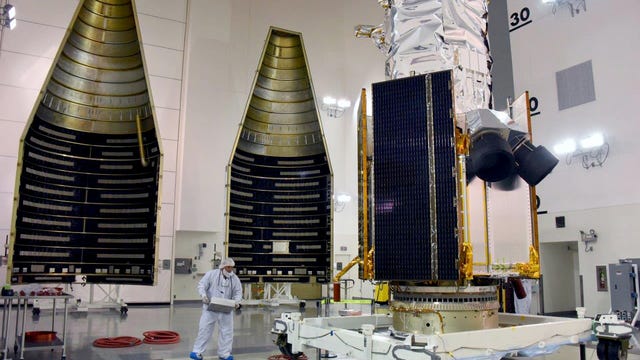
The WorldView-4 is about the size of a pickup truck standing on its nose and weighing roughly as much. It's 5.3 meters (17.7 foot) tall, 2.5 meters (8 foot) across. The solar arrays, when deployed, are 7.9 meters (26 foot) across.
Inside is a telescope 1.1 meters (43.3 inches) wide with 3.2 terabytes of onboard storage . It tracks its position using the locations of the stars as well as the Global Positioning System (GPS), whose satellites are in a much higher orbit.
The camera boasts some impressive specs. Its panchromatic (black and white) resolution is 31 centimeters (12.2 inches) per pixel, while the multispectral (or color) resolution is 124 centimeters (48.8 inches) per pixel in red, green, blue and near-infrared wavelengths. The higher resolution of black and white may seem odd, but this is actually similar to how your TV works. There is far more black-and-white detail than there is in color, because your eye can't see as much detail in color as it can with black and white.
The WorldView-4 is similar to the WorldView-3 satellite, which is already in orbit. The 4 was actually built around the same time as the 3. But it was made for the GeoEye company, which DigitalGlobe bought in 2013. The 4 should have a lifespan of 10-12 years.
Though raw satellites are undeniably cool, they aren't quite as awesome as they could be. A bit of work is sometimes required to clean them up a bit. DigitalGlobe processes the images using a method called Atmospheric Compensation to remove haze and thin clouds.
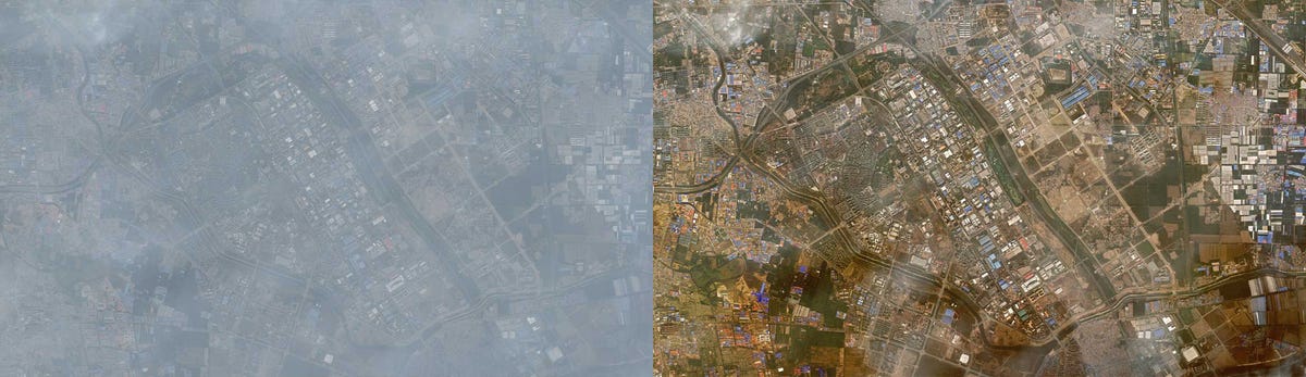
Before and after DigitalGlobe's "AComp" processing.
Beyond your back yard
Sure it's cool to zoom in and look at your house, but of course there's more uses than just that.
There are several Instagram accounts that find creative uses for DigitalGlobe imagery. One of my favorites is Daily Overview, which finds random parts of the world and gives you a bit of background about what's there.
DigitalGlobe sells or makes its images available to a variety of companies and governments for different uses. The AP used DigitalGlobe images to help track fish caught and processed by pirates and their slaves (no, seriously) and it also helped track the Fort McMurray wildfire, study remote human settlements and more.
TomNod uses DigitalGlobe's images and crowdsourcing to count seals in Antarctica, map typhoon damage and even help try to find the wreckage of Malaysia Airlines Flight 370
Because the company's image library goes back nearly 20 years, it can also help track the ceaseless worsening of climate change.
All eyes on Earth
In the past few years several companies have entered the satellite imagery arena, each with their own niche. Google's Terra Bella has 90-centimeter photo resolution and 1.1-meter HD video resolution. UrtheCast has video cameras on the ISS, and you can see a live feed right now.
Then there's Planet Labs, which uses tiny CubeSats. Their resolution isn't as impressive, but there are over 90 in orbit so they offer incredible coverage. Here's a view of them deploying from the ISS.
A satellite's eye view
It's easy to take technology for granted. It's easy to click on Google Maps, take a look at where you are or where you're headed, and see a bird's eye view with lots of detail. But often it's not a bird's eye view at all. It's from a satellite hundreds of miles above that took a picture months or years ago. Then that photo was beamed down from space and sent to your phone wirelessly from a tower you can't even see. That's pretty cool.
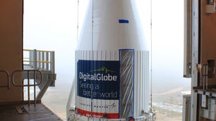
And if you want your own imaging satellite? It only cost $835 million to build, launch and insure the WorldView-4. Check your couch cushions.
Got a question for Geoff? First, check out all the other articles he's written on topics such as why all HDMI cables are the same, LED LCD vs. OLED, why 4K TVs aren't worth it and more. Still have a question? Tweet at him @TechWriterGeoff then check out his travel photography on Instagram. He also thinks you should check out his sci-fi novel and its sequel.