Startling NASA Satellite Image Shows Hurricane Ian's Wide Eye
The powerful storm's eye appeared as a massive swirl of clouds just hours before landfall in Florida.


NASA's Landsat 8 satellite captured this natural-color view of Hurricane Ian's eye on Sept. 28, 2022.
Large areas of Florida are working on recovery and cleanup after a devastating blow from powerful Hurricane Ian last week that's claimed at least 100 lives. Scientists are working to learn more about the hurricane's behavior to help with forecasts for future storms. A NASA satellite view of the storm's eye on Sept. 28 gives some clues as to why Ian was so dangerous.
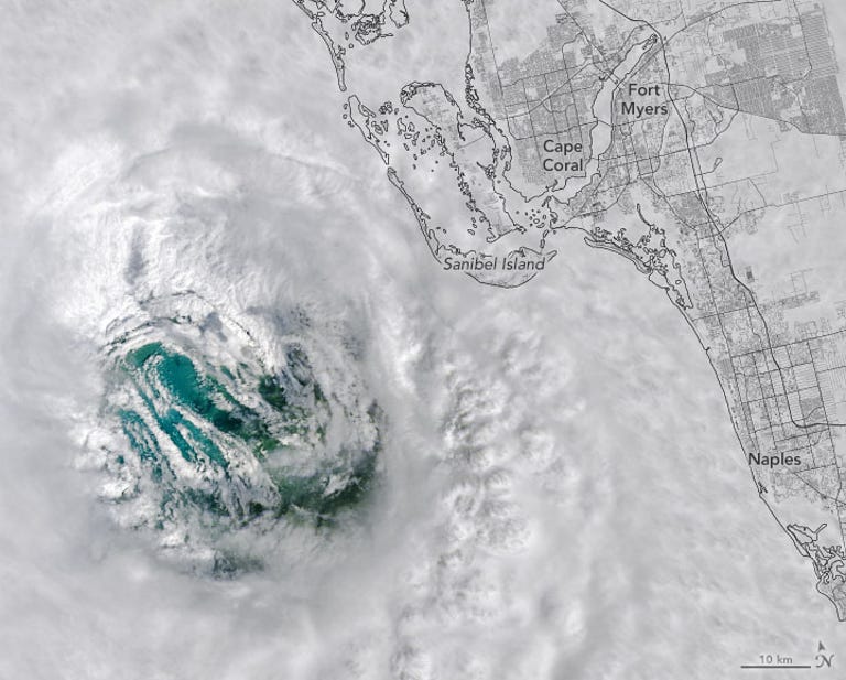

An overlay map shows where Ian's eye was on Sept. 28, 2022 as it approached Florida.
NASA operates the Earth-observing Landsat 8 satellite along with the United States Geological Survey. The hurricane's eye is shown with remarkable clarity with a surrounding of clouds and blue-green water visible below. The image is in natural color so it's what you'd see looking down with your own eyes.
The area surrounding the eye is made of a ring of thunderstorms called the eyewall. "The swirling clouds along the edges of the eyewall are mesovortices -- small-scale rotational features found in hurricanes with unusually strong winds," NASA said in a statement on Tuesday.
Ian reached Florida as a slow-moving, tremendously powerful Category 4 storm. At the time of the image -- just three hours before the storm reached the island of Caya Costa -- the eye stretched 26 miles (42 kilometers) across, down from an earlier width of 34 miles (55 kilometers).
"Those breathtaking low-level cloud swirls in Ian's eye might provide clues into some important processes that affect a hurricane's intensity," said researcher Justin Whitaker, in a NASA Earth Observatory statement on Saturday. Scientists will continue to study the data and imagery from Ian.
For a very different view of Ian's eye, you can ride along with the Hurricane Hunters aircraft that flew into its center before it reached Florida.
Ian may be a harbinger for storms to come as studies show human-caused climate change is making Atlantic hurricanes wetter and more dangerous.