Astronaut's grim photos from space show hurricane destruction
ISS commander Randy Bresnik shares pictures of Hurricanes Irma and Jose and also of the devastation they leave behind.


- Co-author of two Gen X pop-culture encyclopedia for Penguin Books. Won "Headline Writer of the Year" award for 2017, 2014 and 2013 from the American Copy Editors Society. Won first place in headline writing from the 2013 Society for Features Journalism.
ISS commander Randy Bresnik remains on hurricane watch from his perch about 260 miles (419 km) above Earth, and now he's added looming Hurricane Jose to his list.
The NASA astronaut is making himself a must-follow on Twitter, sharing not just photos of Jose and Hurricane Irma, but giving Earthlings views of the areas that have been unfortunate enough to land in the storms' paths.
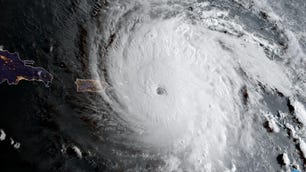
Unfortunately, a tale of two hurricanes…… First #Irma. pic.twitter.com/isyLaWUteX
— Randy Bresnik (@AstroKomrade) September 10, 2017
The eye of #Jose, may it veer north and east away from those so affected by Irma’s wrath already. pic.twitter.com/g6RtKGx2CD
— Randy Bresnik (@AstroKomrade) September 10, 2017
What a difference a week makes, Turks and Caicos before and after #Irma. pic.twitter.com/BAm438TSwe
— Randy Bresnik (@AstroKomrade) September 10, 2017
The beautiful sands of Turks & Caicos churned up into a kaleidoscope of colors after #Irma. pic.twitter.com/Z0tZI46JCX
— Randy Bresnik (@AstroKomrade) September 10, 2017
In #Irma’s wake Turks & Caicos, Haiti, Dominican Republic, Puerto Rico, and the Virgin Islands…. pic.twitter.com/Z5sF4rrX8g
— Randy Bresnik (@AstroKomrade) September 10, 2017
The US Virgin Islands reeling from #Irma’s passage…. pic.twitter.com/sMtDxS7I9N
— Randy Bresnik (@AstroKomrade) September 10, 2017
The tentacles of the bow wave of #Irma clawing its way up Florida…. pic.twitter.com/BKCS8RrCnB
— Randy Bresnik (@AstroKomrade) September 10, 2017
On Monday, as Hurricane Irma turned into a tropical storm, Bresnik tweeted new photos, including a stunning double image looking inside the eye of the next hurricane, Jose, showing the path all the way through its swirling clouds to the Earth.
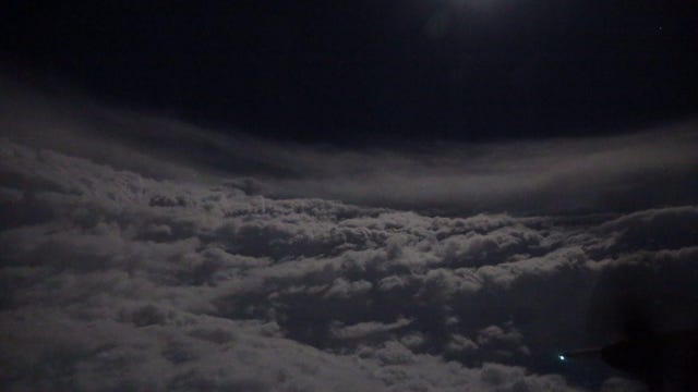
A walk inside the Eye of #Jose. Just amazing to see through the eye to the surface! pic.twitter.com/5IwlKLOWfN
— Randy Bresnik (@AstroKomrade) September 11, 2017
Another comparison showed that while Jose may be a little brother of sorts to massive Irma, he's not to be messed with himself.
#Irma Massive! #Jose, not as massive but just as destructive to those reeling from the previous hit. pic.twitter.com/RYCTjmz4q4
— Randy Bresnik (@AstroKomrade) September 11, 2017
And he even caught a glimpse of Jose's retreat from the Caribbean's windward islands.
With #Jose exiting off, the windward Caribbean islands can now begin their recovery. pic.twitter.com/yMTJoQFarY
— Randy Bresnik (@AstroKomrade) September 11, 2017
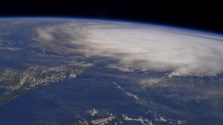
On Thursday night, Bresnik tweeted a sobering photo of Hurricane Irma swirling menacingly above the Caribbean.
Not all of Bresnik's images are storm-centered. He also shares photos of areas that are safely out of the storm's path.
Between the Dead Sea & the Red Sea, carved out of the face of the rock, the ancient city of Petra is a wonder to behold. #OneWorldManyViews pic.twitter.com/qWUim3rHq4
— Randy Bresnik (@AstroKomrade) September 10, 2017
The beautiful blue of that Budapest twilight matches the blue we see on the horizon from orbit. #OneWorldManyViews pic.twitter.com/OsvtMJWHgp
— Randy Bresnik (@AstroKomrade) September 9, 2017
Follow @AstroKomrade ("Komrade" is Bresnik's nickname) on Twitter for storm -- and other -- updates from space.
Updated on Sept. 11 with more photos.