Beastly Southern California earthquake created a crack seen from space
Satellites caught sight of a surface rupture etched by the Ridgecrest earthquake.


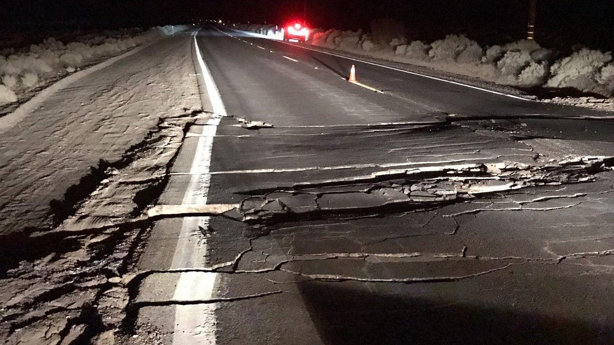
The USGS shared this view of a highway broken apart by the recent Ridgecrest earthquake.
Swimming pools splashed over their rims. Disneyland rides came to a halt. A baseball stadium rocked. The 7.1-magnitude Ridgecrest earthquake shook California on July 5 and left a notable scar behind for satellites to witness.
Planet Labs' Doves satellite system images all of Earth every day. Planet Labs CEO Will Marshall shared his company's view of the damage to Twitter on Sunday.
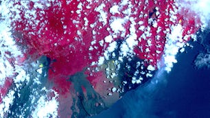
Ridgecrest Earthquake before (4th July) & after (6th July) images from Doves, clearly showing surface rupture. Thx @rsimmon @PlanetLabs @USGS RT @USGSBigQuakes Prelim M7.1 Earthquake 35.767, -117.605 Jul-06 03:19 UTC, updates https://t.co/waWvmvQZ88 pic.twitter.com/cUNxdMazum
— Will Marshall (@Will4Planet) July 7, 2019
The before-and-after images come from July 4 and July 6 and show a significant surface rupture near the epicenter. This kind of rupture occurs when the ground offsets during an earthquake. It looks like a slash or crack cut into the earth.
Marshall's image also points out an area of dewatering, which happens when water and sediment fountain up from the ground due to an earthquake's intense shaking action.
NASA earthquake scientist Chris Milliner turned the Planet Labs images into a GIF to better illustrate the ground movement.
Satellite imagery from @Planetlabs shows surface rupture of the Mw 7.1 July 5th #earthquake. There is much larger fault slip here than the Mw 6.4, ~2m of right-lateral offset at this location (35.79, -117.61). Slip profile and correlation results to come. pic.twitter.com/RMZX9XydeM
— Chris Milliner (@Geo_GIF) July 7, 2019
The United States Geological Survey is also making use of satellite imagery to help investigate the recent earthquake activity. The USGS shared a video on Monday tracking earthquake events just prior to the 6.4 rumbler on July 4, all the way through to noon on Monday.
This video shows earthquake events a few hours before the M6.4 on July 4th, 2019 to present (as of above noon on July 8th, 2019). #earthquake #usgs #californiaearthquake pic.twitter.com/c5JEDynLQ4
— USGS (@USGS) July 8, 2019
The earthquake and aftershock action shows up in the form of yellow dots over a Google satellite map of the area.
The USGS also shared a view from much closer up when it tweeted a look at a buckled road near the small community of Trona, California.
This photo was taken on 178 SW of Trona. The road is now closed for repairs. pic.twitter.com/TOuf6XlwgJ
— USGS (@USGS) July 6, 2019
California residents are bracing for potential new earthquakes or aftershocks while satellites continue to keep an eye on what's shaking down on Earth.