In a Texas border town, a church on the edge and wildlife at risk
Some South Texans say they'd rather live with constant surveillance by Border Patrol than a physical barrier.


More than 100 pilgrims quietly make their way into La Lomita Chapel and slide onto the wooden pews of the 120-year-old Catholic church. As one man sits down, he hangs his cowboy hat on a post near the pulpit. The one-room adobe chapel is lit only by a table of flickering votive candles. It's a cool February morning in Mission, Texas, and the sun has yet to rise.
"We pray for ourselves," Father Roy Snipes says with a Texan lilt, holding a flashlight as he reads his sermon. "But we also pray for our oppressors."

This is the third story in our Texas border trilogy, Tall Order: Building the Border Wall. Click here for the first story and click here for the second story.
Snipes, who's tall with a slight stoop and combed white hair parted on the side, has served at La Lomita Chapel for nearly 40 years. As he continues his sermon, he turns to a topic his parishioners are familiar with: the border wall.
La Lomita sits directly in the path of President Donald Trump's proposed wall. The tiny white church is situated in a grassy park less than a block from the dark green Rio Grande -- the international boundary between Texas and Mexico. That has turned this historic landmark into a symbol of what might be lost once the wall is built. And it's turned Snipes, who's locally known as the "cowboy priest" and has been described as "Mr. Rogers with a Stetson," into an unlikely symbol of protest against the physical barrier the Trump administration just started building in Texas last month.
"In the long run, it's going to be a real sad chapter in our history, that wall," Snipes says. "It's a shame they couldn't think of something better than that with all of the tech we have."
The US Border Patrol has blanketed the nearly 2,000-mile-long US-Mexico border with technology, most of it geared toward surveillance. The agency relies on a network of sensors, cameras and drones equipped with lidar and radar to spot people, boats and vehicles crossing the border into California, Arizona, New Mexico and Texas. Watchdog groups warn that this mass surveillance could have serious privacy implications. But a wall, say the dozens of Texans living along the border who granted me interviews, may be even worse.
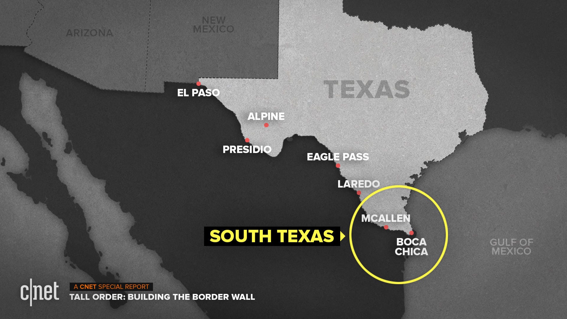
If all goes according to Trump's plans, roughly 550 miles of wall will be built along the US-Mexico border as soon as possible. Most of that new construction is expected to happen in Texas. Unlike California, Arizona and New Mexico, which already have about 60% of fencing or walls at their borders, Texas only has around 20% because of its natural barrier with Mexico -- the Rio Grande.
I set out to travel the length of the Texas-Mexico border, about 1,200 miles, starting in El Paso and ending here at the southern tip of the state in the Rio Grande Valley. While much of the border is remote and desolate, South Texas is different. It's peppered with numerous towns whose inhabitants live on both sides of the river. It's also one of North America's top biodiversity hotspots for birds, insects and animals, such as the endangered ocelot and Kemp's ridley sea turtle.
Building a wall in the middle of such a wildlife corridor will harm the hundreds of different species that live here, say scientists and conservationists across Texas. It also puts at risk the future of La Lomita.

Father Roy Snipes, the parish priest at La Lomita chapel, holds a dawn mass in Mission, Texas.
As Snipes finishes mass at the chapel, birds chirp awake and a hawk hovers in the nearby field. Through the church's windows, the sky over the levee is cast in red, peach and bright turquoise. In the other direction, a low fog lifts off the river. Overhead, a Border Patrol helicopter buzzes.
"They think they're going to build a wall and it'll solve all of our problems," Snipes says. "I think it's going to cause more problems than it's going to solve."
Surveillance state
The Rio Grande Valley isn't actually a valley, it's a river delta. It's flat, dry and hot. Along Highway 83, one-stoplight towns sell tacos and barbecue brisket out of roadside trailers, and broken-down gas stations are a mainstay. Through the dense and thorny brushland filled with sweet acacia, Texas ebony and mesquite trees, the Rio Grande drifts in and out of sight.
Every few dozen miles, a white blimp floats 5,000 feet in the sky. Called aerostats, or tethered aerostat radar systems, these apparatuses look like a cartoon version of an airplane, with a softly rounded nose and curved puffy tail wings. They're one of the surveillance tools US Customs and Border Protection uses to monitor the border.
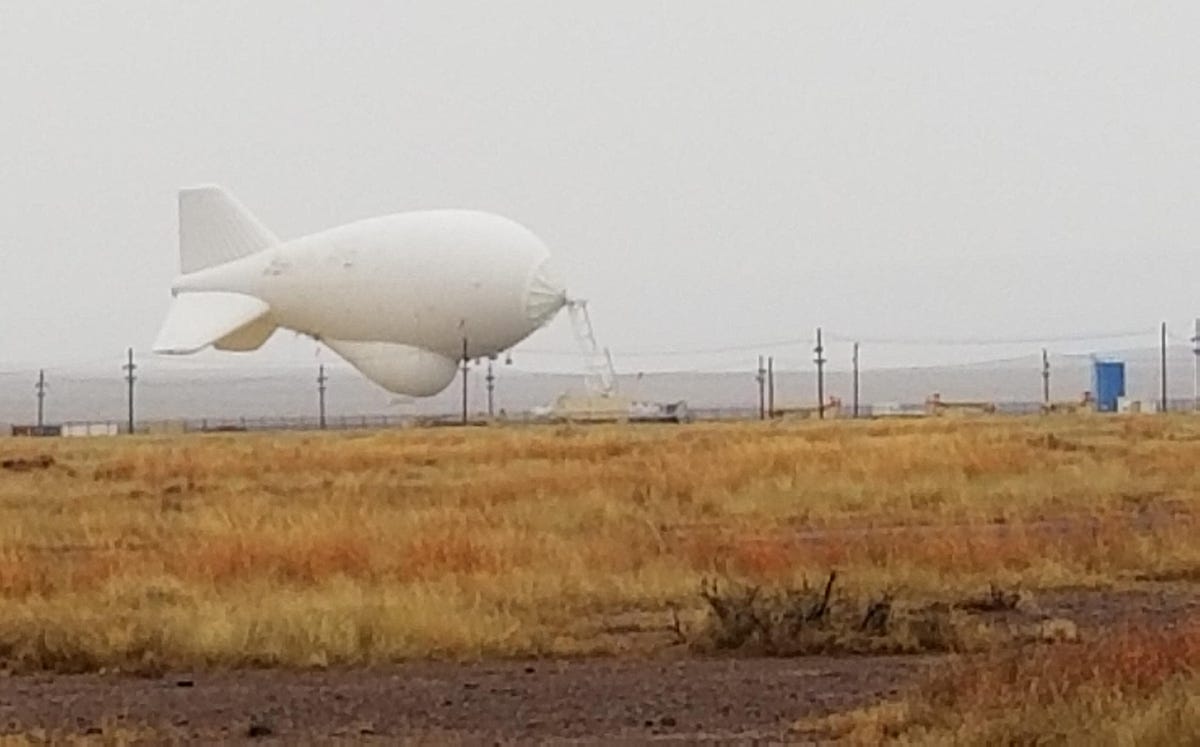
An aerostat, used for border surveillance, gets lowered to the ground in rainy weather.
Each balloon is attached to the ground by a nylon cable that can be extended and reeled in. When in the air, the unmanned aerostats monitor the terrain below. Using radar, along with infrared and electro-optical cameras, they can "see" approximately 20 miles and pick up the movement of people and vehicles, according to Customs and Border Protection.
The Border Patrol has six tactical aerostats in the Rio Grande Valley. Each blimp's radar and camera feeds are monitored 24 hours a day by government contractors and a Border Patrol agent, according to Jose A. Martinez, assistant chief patrol agent.
"It has greatly assisted us," Martinez says. But, he adds, "The aerostat has its limitations because it's only operational 60% to 70% of the time due to weather and maintenance."
Aerostats are just one of the Border Patrol's surveillance tools. To detect potential illegal immigration and drug trafficking, the federal agency uses everything from surveillance towers equipped with high-powered cameras to military grade drones to a complex system of sensors, including seismic, magnetic, acoustic, infrared, radar, microwave and photoelectric. The Border Patrol is also testing innovations such as machine-learning AI software and facial recognition tech.
The federal government is pouring money into border technology. A congressional spending measure, passed Feb. 14 and signed by Trump, awarded $100 million in technology funding to the Border Patrol, with an additional $112 million for aircraft and sensor systems.
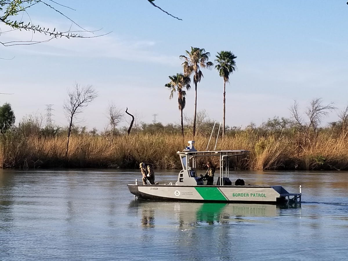
Border Patrol agents keep watch on the Rio Grande in Mission, Texas.
But some people aren't happy with the indiscriminate surveillance. A group of 28 tech and human rights organizations, led by digital rights group Fight for the Future, has been pushing Congress to stop funding border surveillance tech.
"It's sickening to see both Republicans and Democrats add significant funding for invasive surveillance technologies to trample on millions of people's basic rights at a mass scale," Evan Greer, deputy director of Fight for the Future, said in a statement after Congress passed its spending measure in February. "The US government's mass surveillance programs are already out of control."
Civil liberties groups and some think tanks are also opposed to added border surveillance. Libertarian think tank Cato Institute says the tech "intrudes on law-abiding Americans' privacy" and it'd "be naive to believe that Border Patrol surveillance equipment won't be turned on Americans going about their days."
Neema Singh Guliani, a lawyer for the American Civil Liberties Union, says, "A lot of us would have objections to surveillance infrastructure in our communities that could track everywhere we went, every time we went to a doctor's office or a place of worship."
Still, many people who live in South Texas say all that surveillance is better than a physical barrier.
"You don't have to build the wall; you could increase border security, you could increase technology," says Susan Keefer, an avid birder and part-time resident of Mission. "In some places a wall might be best, but it sure isn't right here."
Trapped between the river and the wall
The National Butterfly Center sits on 100 acres of riverside property that's thick with vegetation. Within that tangle of bushes and trees, it's teeming with wildlife. Kids on a field trip are learning about local butterflies, like the zebra heliconian and southern dogface. And birders walk the grounds, stopping to fix their binoculars on a small gray screech owl sleeping in a tree and a flock of bright green jays that jump branch to branch.
The Rio Grande Valley is one of the most biodiverse habitats on the continent. It's home to 1,200 plant species, 300 butterfly species and 520 bird species, according to the US Fish and Wildlife Service. And at least 18 threatened or endangered animal species live here.
"We're at the crossroads of the subtropical and tropical Americas," says Marianna T. Wright, executive director of the National Butterfly Center. "If you're doing a Venn diagram, the Rio Grande Valley is that sweet spot in the middle."
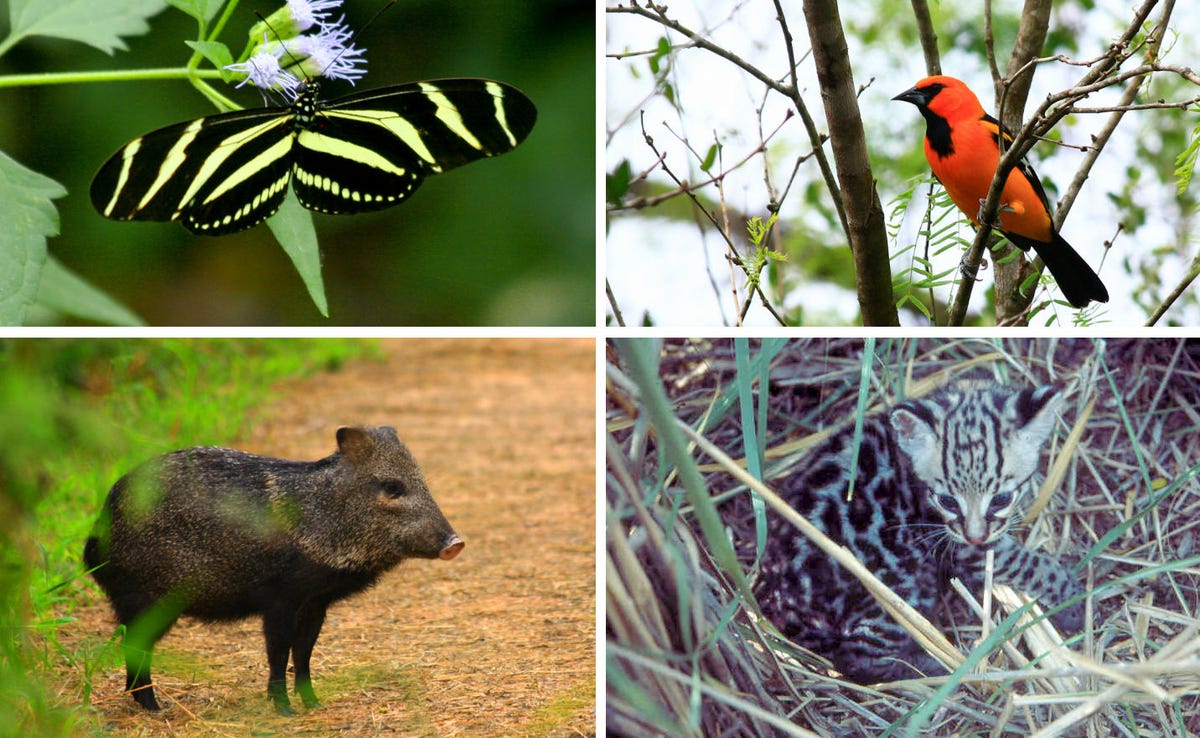
The Rio Grande Valley is home to hundreds of species of birds, butterflies and animals. Clockwise from the top left: zebra longwing butterfly, Altamira oriole, ocelot cub, javelina.
Down the road from the Butterfly Center in a flat, dusty lot enclosed by a chain-link fence topped with barbed wire, a completely different scene started taking place on April 16. Flatbed 18-wheelers began hauling in truckloads of massive steel bollard panels. Bright orange tractors unloaded the oversized metal planks, placing them in several 10-foot-high stacks across the lot. These are the panels for the border wall.
"We're getting a 36-foot-tall barrier that no terrestrial wildlife will be able to cross," Wright says. "That means trapped between the river and a wall, there will be increased competition for resources, for mating territory, for food, for shelter, for breeding."
So far, the majority of construction on Trump's wall has been replacement of existing barriers. That's about to change.
Along with more funding for border technology, Congress' spending measure authorized $1.375 billion for 55 miles of steel fencing in the Rio Grande Valley. The measure also said, however, the wall couldn't be built in four protected areas: the National Butterfly Center, Bentsen-Rio Grande Valley State Park, Santa Ana National Wildlife Refuge and La Lomita Chapel.
But the day after Trump signed the measure, he announced a national emergency at the southern border, arguing that the US is struggling with an "invasion of drugs and criminals coming into our country that we stop, but it's very hard to stop. With a wall, it would be very easy."

Marianna T. Wright, executive director of the National Butterfly Center, stands with football players Demario Davis and Josh Norman in front of a stack of steel bollard panels that'll be used to build the border wall.
That move lets him tap into more than $6 billion in additional funds, diverted from other government reserves. It also lets him waive environmental assessments and override the no-wall provision for those four protected areas.
While Trump is facing several lawsuits and a congressional challenge to the national emergency, his order stands and construction on the wall moves forward.
Along with the 55 miles of wall authorized by Congress in February, an additional 33 miles of steel barriers in the Rio Grande Valley were funded by Congress in March 2018. Of this, 25 miles of nearly continuous wall are slated for Hidalgo County, where the Butterfly Center and La Lomita are located, according to a July 2018 letter that Customs and Border Protection sent to a nongovernmental organization and that was seen by CNET.
Customs and Border Protection didn't respond to a request for comment on the contents of the letter.
The wall in Hidalgo County will be 36 feet tall -- nearly as high as a four-story building. It'll start at the foot of the levee with an 18-foot base of reinforced concrete and be topped with 18 feet of steel bollards, according to the letter. Detection and surveillance tech will be incorporated into the wall, along with floodlights. All trees and brush will be excavated 150 feet south of the wall toward the river to clear an area called the "enforcement zone."
Environmentalists say this could deal a devastating blow to South Texas' already compromised ecosystem. Agriculture and urban growth have destroyed almost all of the Rio Grande Valley's native brushland, according to the Texas Parks and Wildlife Department. Less than 5% of this habitat remains -- and what's left is mostly along the banks of the Rio Grande. This is where birds nest, butterflies lay their eggs, and animals hunt and burrow.
"This tiny strip of wildlife along the river is now in jeopardy because of the border wall," says Paul Sánchez-Navarro, senior representative for advocacy group Defenders of Wildlife. "We're talking over 50,000 acres of deforestation."

Clear-cutting isn't the only side effect the wall will have on South Texas' wildlife, Sánchez-Navarro says. It'll also cut off access to water and migratory routes for animals. And the 36-foot-tall barrier will exacerbate wind flow, light pollution and trash and debris buildup.
Flooding may be a serious issue too. South Texas is prone to what locals call "rain events," when a sudden storm pours down massive amounts of water. When this happens, the Rio Grande tends to flood very quickly.
"With the wall there, animals would get trapped and drown," Sánchez-Navarro says. "They don't have a way to escape."

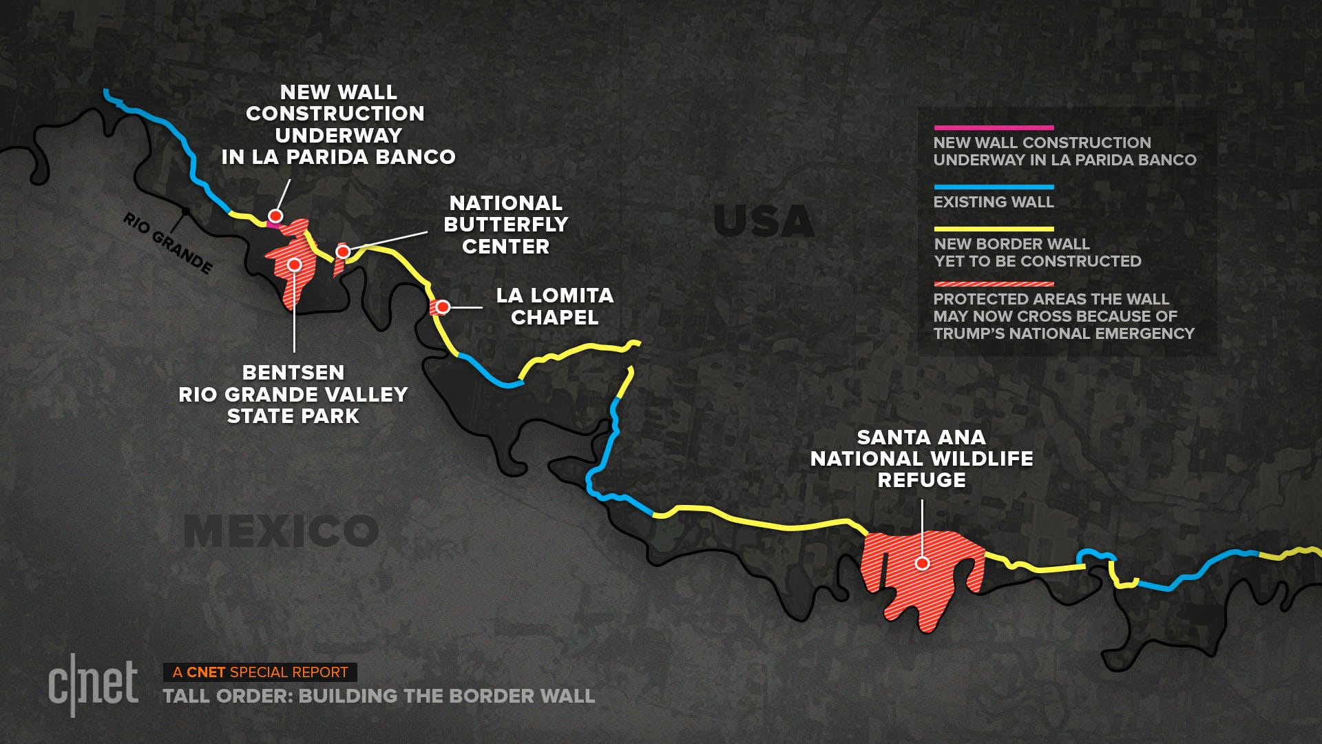
This map shows where the border wall will be built in the Mission, Texas, area of the Rio Grande Valley.
Customs and Border Protection says it's waived various environmental laws to build the wall, including the National Environmental Policy Act and the Endangered Species Act. But it also says it's working with federal, state and nongovernmental organizations to identify the potential impact on wildlife.
"To the greatest extent practicable, CBP will incorporate design considerations to avoid, minimize, or mitigate any potential impacts that are found," the agency says.
A couple miles west of the Butterfly Center, Customs and Border Protection's excavators have already uprooted brush and cleared about eight acres in a tract of land called La Parida Banco, which is in the Lower Rio Grande Valley National Wildlife Refuge. This is the first location in Hidalgo County to get Trump's new border wall.
"It is happening next door to us, but not to us," Wright says. But if Trump's agenda continues, she says, "they will eventually build the wall through us."
'We didn't cross the border, the border crossed us'
After mass, Father Snipes offers to take me on a boat tour down the Rio Grande on his 50-year-old Kenner ski barge. He puts on his cowboy hat and Texas A&M jacket, towels the morning dew off the boat's seats and gets the old barge's motor going.
"And we're off like a band of turtles," he jokes.
The river is wide and calm here, flanked by palms and swamp grass. As Snipes steers the boat downstream, he points to Mexico with its riverside houses and a tidy park full of picnic tables. On the US side, Border Patrol surveillance towers watch over the water. An aerostat hovers in the distance.
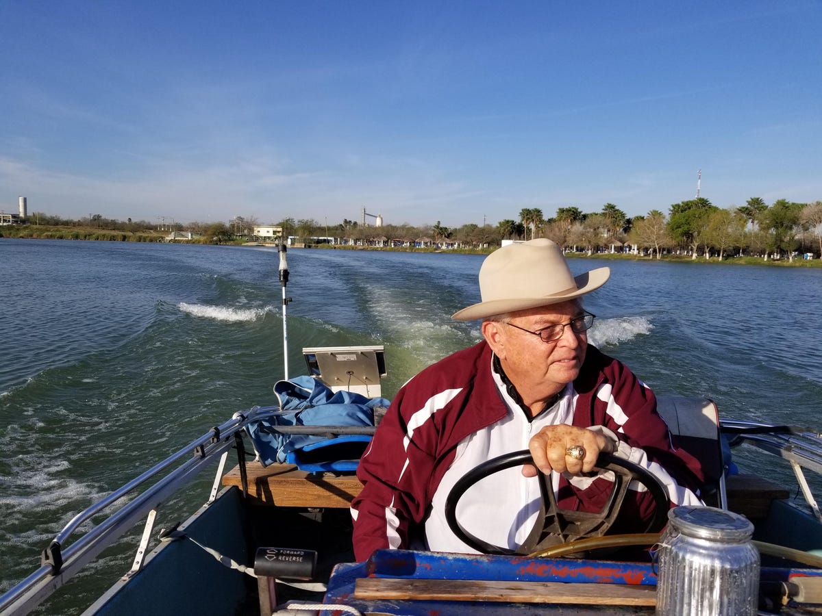
Father Roy Snipes steers his Kenner ski barge down the Rio Grande.
"It's hard to see any signs of a crisis," Snipes says, as he scans the empty river. "The crisis is demonizing and despising your neighbors."
Snipes took his final vows as a priest at La Lomita in 1980 and he's been here ever since. He's had hundreds of parishioners from both sides of the river, including Border Patrol agents and Mexicans who entered the US without papers. The church sits just below the levee, which means it's inside the 150-foot enforcement zone. Snipes says he hasn't heard talk of demolishing La Lomita, but being in a deforested area next to a 36-foot-tall concrete and steel wall will change the church.
"It's such a serene and peaceful place to pray, and if you have a militarized zone right there, it would desecrate the atmosphere," he says. "Couldn't we find something better than a 15th century wall?"
Along with historic sites and wildlife refuges, the Trump administration is also looking to build the wall across residents' private property. Throughout Texas, more than 1,000 landowners are going to be potentially impacted by property seizures, says Rep. Will Hurd, a Republican whose district covers more than 800 miles of the Texas-Mexico border and who opposes a wall along the entire southern boundary.
In the Rio Grande Valley, the government has been sending letters to dozens of property owners over the past few months asking to survey their land for the wall. If the landowners refuse, these matters typically end up in court with the government making a case to seize the property under eminent domain. The Butterfly Center and La Lomita had cases against the federal government over the use of their land, and both cases have been dismissed. The Butterfly Center appealed that decision.
"The messiness of all these takings has become a real burden for people," says Peter McGraw, a lawyer with the nonprofit legal assistance firm Texas RioGrande Legal Aid.

Mission area resident Reynaldo Anzaldua (left) and the mayor of Mission, Armando O'Caña.
Reynaldo Anzaldua's family has lived in the Mission area since before the US was even a country. He's a descendent of the Spaniards who settled on both sides of the river in the 1750s. His extended family owns plots of land throughout the region and even has a land grant dating back to 1767. Now the government aims to build the wall through about 70 acres of his family's property.
Anzaldua, who's soft-spoken with thin, gray hair and wire-rimmed glasses, is a retired customs officer and Vietnam War vet. He says he's opposed to Trump's wall because he doesn't think it's needed or will work.
"One thing I do know about is smuggling. They need to look at the root causes of things," Anzaldua says. "This is about demand for drugs and demand for illegal immigrant labor. If you reduce demand, you reduce violence in Mexico, you reduce problems here."
He and his family are already battling the federal government in court over their land. But their prospects of winning the case don't look good.
Anzaldua says he's also opposed to the wall because he sees this region of South Texas and Northern Mexico as one community, as have the generations of his family who came before him. He doesn't like the idea of dividing it with a barrier.
"We didn't cross the border, the border crossed us," Anzaldua says. "I'm not giving up to the last minute, until it's all done. Then we'll have to work to tear it down."
The river's end
The Rio Grande is the fourth longest river in the US. It originates in the Colorado Rockies, then bends and winds its way through New Mexico and along the edge of Texas to eventually empty into the Gulf of Mexico, 1,896 miles later. After traveling hundreds of miles along this river, I had to see its end.
I drive my rental car toward the gulf, past cabbage, melon and grapefruit farms, to the dunes and salt flats of Boca Chica State Park. When the road ends at a long, desolate beach, I park and walk. It's about three miles to the mouth of the river. A cool, thick fog hangs over the ocean as small waves tumble onto the shore.

Where the Rio Grande empties into the Gulf of Mexico.
Behind me, a lifted black Ford pickup comes driving down the beach. I still have a ways to go, so I give a wave and ask for a ride. It's a couple from Missouri wintering in Texas. A pop country station plays over the radio. Like me, they want to see where the river disappears into the sea. We slowly crawl down the beach until we make it to the mouth of the Rio Grande.
The land out here is open and rugged. It's only about 30 feet across to Mexico. The US side is empty, but on the Mexican side, a handful of fishermen in fluorescent green waders stand shin deep, casting their nets. Herons, gulls and pelicans look on.
As I'm taking it in, I'm reminded of a plaque I saw at the Butterfly Center engraved with a quote from the writer Wallace Stegner:
"Something will have gone out of us as a people if we ever let the remaining wilderness be destroyed. … We simply need that wild country available to us, even if we never do more than drive to its edge and look in."
A small, black SUV pulls up to the water's edge across the river in Mexico. A family of four gets out to take in the view, just the same as us. The dad looks over at me, standing here on the US side. He smiles and waves.
Tall Order: Building the Border Wall is our Texas border series exploring what a wall and tech alternatives might mean to the people, communities and law enforcement agencies living in its shadow. Read the first story here: Trump wants a border wall. Texas may want a smarter alternative, and the second story here: At Texas border, tech can't keep pace with immigrant influx.