NASA images show thinning Arctic sea ice
The space agency and the National Snow and Ice Data Center are concerned over data showing smaller amounts of thick permanent ice and more thin melting ice caps.


Arctic sea ice is not only shrinking in coverage area; it's also thinning, according to a report and satellite images jointly released on Monday by NASA and the NASA-supported National Snow and Ice Data Center at the University of Colorado.
The Arctic basin is covered in a thick semipermanent sea ice, which is covered in thin seasonal ice caps that are built up each winter, only to melt away again each summer.
The 2009 Arctic summer-melting season is starting out with a substantial amount of thin seasonal ice and an unusually small amount of the thick sea ice, making it more vulnerable to melting, according to the NSIDC's report.
"Thin seasonal ice--ice that melts and refreezes every year--makes up about 70 percent of the Arctic sea ice in wintertime, up from 40 (percent) to 50 percent in the 1980s and 1990s. Thicker ice, which survives two or more years, now comprises just 10 percent of wintertime ice cover, down from 30 (percent) to 40 percent," according to the report from the University of Colorado team led by Charles Fowler.

The findings should not be entirely surprising to those who have been following NASA and the NSIDC's research. In September 2008, the groups issued a joint report that the Arctic's thick permanent ice was at one of the lowest levels on record, in terms of coverage area.
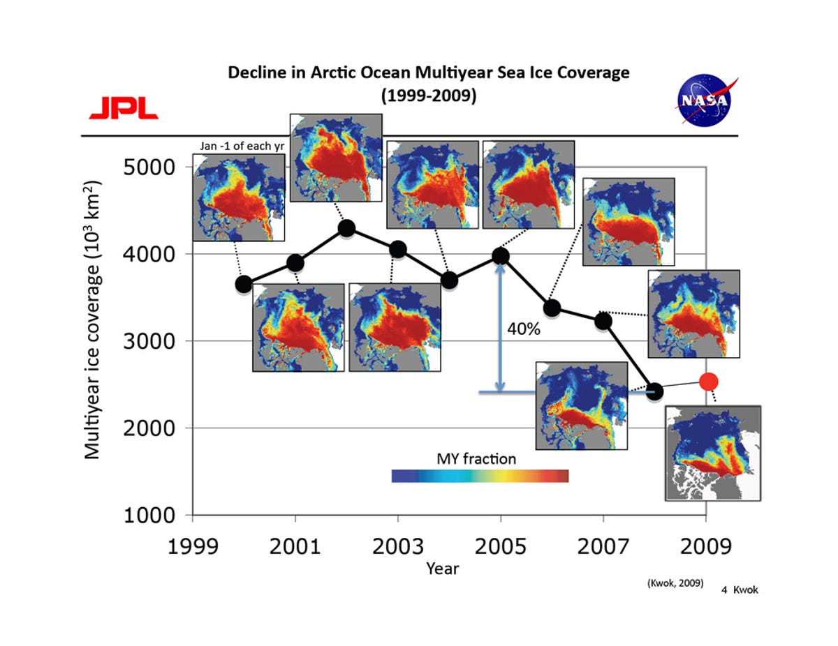
A team led by Ron Kwok of NASA's Jet Propulsion Laboratory is further examining sea ice data to determine if there's a correlation between the reduction in sea ice coverage area and the changes in thickness and volume.
"Sea ice thickness has been hard to measure directly, so scientists have typically used estimates of ice age to approximate its thickness. But last year, a team of researchers led by Ron Kwok of NASA's Jet Propulsion Laboratory in Pasadena, Calif., produced the first map of sea ice thickness over the entire Arctic basin," according to NASA's report.
Kwok's team is using data from NASA's IceSat (Ice, cloud, and land elevation satellite) to measure Arctic sea ice thickness and volume for 2003 to 2008, to see if there's is a correlation between sea ice coverage area and volume.
So far, the team has reached the same conclusion as Fowler's group.
"The older, thicker sea ice is declining and is being replaced with newer, thinner ice that is more vulnerable to summer melt," Kwok said in a statement.
"With these new data on both the area and thickness of Arctic sea ice, we will be able to better understand the sensitivity and vulnerability of the ice cover to changes in climate," he said.