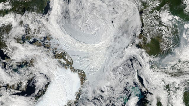
NASA satellite peers at Hurricane Irma's churning eye
A weather satellite delivers a close-up look at the frightening eye of Hurricane Irma.


Late afternoon sun casting a shadow on Hurricane #Irma's eye. #GOES16 pic.twitter.com/CQaSgHzVN6
— NASA SPoRT (@NASA_SPoRT) September 5, 2017
Sometimes the eye of a hurricane looks anything but calm.
Hurricane Irma is tearing across the Atlantic Ocean, striking Caribbean islands and heading towards the US coast. It's classified as a Category 5 storm with maximum sustained winds near 185 mph (295 kmh). NASA's GOES-16 weather satellite captured a sequence of images that show Irma's eye swirling in frightening fashion.
NASA's Short-term Prediction Research and Transition Center (SPoRT) posted a GIF of the eye to Twitter on Tuesday, noting how the late afternoon sun cast a dramatic shadow on the circular formation at the center of the dangerous storm. The SPoRT program is focused on sharing NASA's satellite data with weather forecasters.
NASA launched GOES-16 in late 2016. It now watches Earth from about 22,300 miles (36,000 kilometers) away. NASA offers real-time imagery from its GOES satellites online, so you can follow the view of the storm from orbit.