Military challenge: Make spy data more accessible
Two government agencies sponsor a demonstration called the Empire Challenge in an effort to improve interoperability between various Web-connected intelligence and surveillance devices.
Action spy dramas increasingly feature a computer geek character who accesses everything from satellite imagery to floor plans to convenience store security cameras, then feeds the data to his team, saving the day. This type of work, it turns out, is easier said than done.
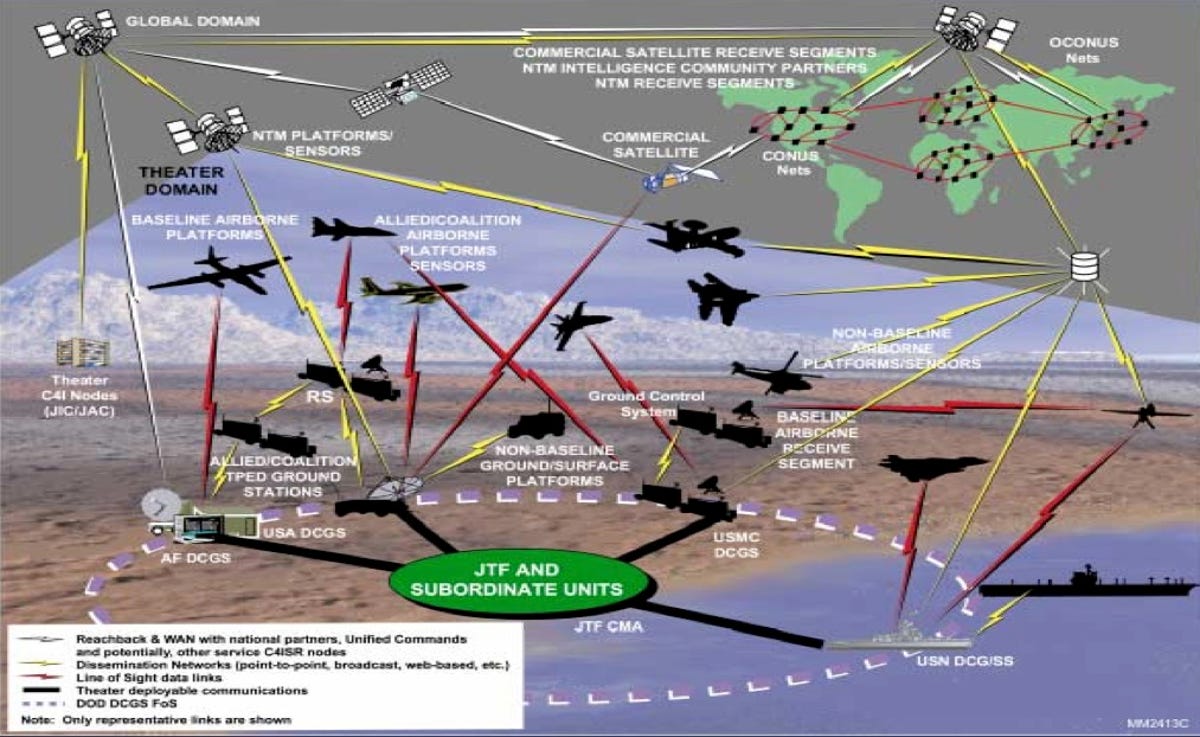
Two agencies are trying to make it easier to access and blend Web-based snoop-scoop. The U.S. Joint Forces Command and the National Geospatial-Intelligence Agency are sponsoring an annual demonstration called Empire Challenge, which "seeks to improve interoperability of intelligence, surveillance, and reconnaissance activities" among end users.
One of last year's Challenge participants, the Open Geospatial Consortium, or OGC, has already demonstrated a common interface that allows "analysts to detect and access sensors from different sources."
"Let's say you're an analyst, and you want (to find) out what's going on in Bellingham, Wash., and you don't know what sensors are available in Bellingham," said Sam Bacharach of OGC. "Is there a Predator with an electrical-optical camera overhead? Maybe there are Washington State Patrol cameras on the interstates. Right now, just to know all those things exist, you have to go through an exhausting process to find them."
And we're not just talking traffic cameras. OCG aims to enable real-time integration of virtually any Web-connected device; examples cited include flood gauges, air pollution monitors, stress gauges on bridges, mobile heart monitors, assorted robots, and the usual space- and airborne-imaging devices.
"In a perfect world, in the world we're trying to enable, all of the sensors may come online," Bacharach said. "They would be put in a catalog so the operator could then come in and type in Bellingham, and magically get a map of all the sensors and all the data that is available covering Bellingham, Wash."
Joint Forces Command hopes lessons from this year's demonstration will allow it to integrate OGC's interface capabilities into the Distributed Common Ground System-a classified architecture used to share sensor information within the intelligence community.
The goal is to shorten the time it takes to collect and analyze intelligence, and disseminate it to troops on the battlefield.
The Empire Challenge is open to government agencies, private industry, and academia; in case you want to channel Marshall J. Flinkman in helping track the Enemy of the State.