Waze iPhone app provides real-time, crowdsourced traffic data
A new app brings the wisdom of the crowds to iPhone-based traffic applications. And Waze is free, potentially a big step up since most competitors charge for their services.


SAN FRANCISCO--We're driving through the heart of the city, cruising along at a nice clip, but just in case we hit a patch of rough traffic, I know which alternate route I can take to go faster.
That's because I've got an iPhone with Waze, a new app released Thursday that's designed to give drivers a wide range of crowdsourced road information including traffic flow, road reports, and even warnings about where the latest speed traps have been set up.

Waze, which has been out for some time on the Android platform, is new to the iPhone, and its developers clearly think that Apple's hit phone, complete with GPS and accelerometer, is a natural device for giving drivers a way both to inform each other about what's happening on the road in real time, and to learn from others about what's ahead.
The app begins as a standard turn-by-turn directions tool and then offers a slew of other features, many of which give drivers something fun to look out for as they make their way to wherever they're going.
"At the end of the day," said Di-Ann Eisnor, Waze's community geographer, Waze is "about a community of drivers helping to build this map."
And, to be sure, the map is the heart and soul of the Waze app. In the car I was in, there were three different iPhones running the application, and because of that, I was often able to see three different views of what Waze can do.
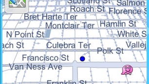
One of the most fun parts of it--and in some ways the most social--is that the app allows you to see the location of anyone else nearby who is also running Waze. And while there is no way to communicate directly with such drivers, or find out anything about them, it still feels gratifying to see them pop up on the map.
Nearly real-time
Eisnor explained to me that Waze is designed to offer drivers real-time information about the roads they commute on, generally with no more than a 30-second delay. And that's because most of the information that's available is being relayed from other Waze users.
To be sure, the app will require a critical mass of users to have real utility, and it certainly isn't there yet: In about 30 minutes of driving around, we saw no more than four or five other Waze users pop up. But Eisnor argues that it won't be long before that critical mass comes. In Israel, she pointed out, more than 20 percent of smartphone users have Waze on their devices, despite the service only being available since January.
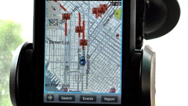
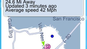
One of the features that has the most potential is one that shows you the speed of traffic on roads near where you are. That's possible because the Waze service is constantly measuring your progress, thanks to GPS, and is reporting back about your movements.
Fear not about your privacy, Eisnor said. She explained that while there are some elements of the service that may eventually be able to tell users something about others, for now, Waze is making sure that everyone has complete anonymity.
And that's probably good, since many drivers probably don't want anyone to know that they're sending out warnings about the whereabouts of police or the location of speed traps and speed cams.
But other users will no doubt be eager for such alerts, just as they might well want to get photographs showing traffic conditions just ahead of where they are.
Ultimately, the point of the application is to offer users "actionable" information. In other words, information that they can use to change a route, avoid an accident, or stay away from a potential speeding ticket.
Eisnor explained that Waze's maps come from the U.S. government and have large amounts of incomplete information. Many roads, for example, are displayed as "unconfirmed" and are depicted by lines of small, gray dots. But instead of treating that as a problem, Waze instead presents it as an opportunity for users to be the first to drive unconfirmed roads and earn points for being the first to confirm them.
Similarly, you can be the first to create a new road, one that isn't shown at all, an action that is rewarded with a nice, solid red line on the map as you drive.
Data about drivers' actions is fed back to Waze, but it's a series of local area managers--sort of like Wikipedia administrators--who do much of the local map administration. Users can get new access to the maps, and the ability to serve as local area managers by building up a large number of the points that they collect by being the first to confirm roads.
For now, Eisnor said, that's the extent of what Waze plans to do with points, but she hinted there would be something more interesting in the not-too-distant future.
Licensing the road data
The Waze app is free, and so I wondered what the company's business model is. Eisnor said that the goal is to get the app in enough people's hands that there is a steady flow of new road data to add to the Waze database. Then, she said, the company plans to license that raw data to other companies to do with as they please and, in the process, grab as much of what it thinks is a $4 billion market as it can. But to users, such goals may well be unimportant, so long as they can continue to get the very latest information about what's ahead of them as they drive.
One flaw in the plan is that, since Waze is dependent on AT&T's network to provide access to the Internet, the service is also heavily dependent on connectivity over that network. And during my half-hour tour around San Francisco--a notorious bad AT&T city--we constantly lost the signal.
For me, losing the signal might end up being incredibly frustrating. And for that, or for any other reason a driver might become upset or angry, Waze offers the ability to change your avatar's mood. Then, anyone in your vicinity can see the new mood when they see your avatar as it drives nearby, whether you're angry, happy, sad, or something else.
Much of that is window dressing, however. The main point of the app is to give users the important, indispensable information they need when trying to commute from point A to point B, be it map data, road information, traffic updates, or the location of the police.
"When using it every day," Eisnor said, "you're providing value to other drivers and other drivers are providing value to you.
To my mind, Waze is an app that has a lot of potential and could well become a truly crucial application. But until there is a critical mass of users, it's only a fun toy.
That said, there's no doubt that Waze is a lot of fun, especially because you get to be part of what could well end up being a wide network of users, each of whom is willing to showcase their location at any time.
For the moment, however, seeing the occasional angry face or noticing that there are several other Waze users in your vicinity may have to suffice. But if critical mass becomes a reality, look out.