These drones can save lives.
Dams, bridges, and other massive infrastructures need regular inspections to guarantee there are no cracks or damages that could compromise safety.
Traditionally, these operations require a crew of professionals repelling from dangerous heights.
But with the inclusion of drones, these inspections become safer, more accurate, and less expensive, which means that the teams can perform more of them.
But how do they do it?
And what does it take?
Let's get into it.
[MUSIC]
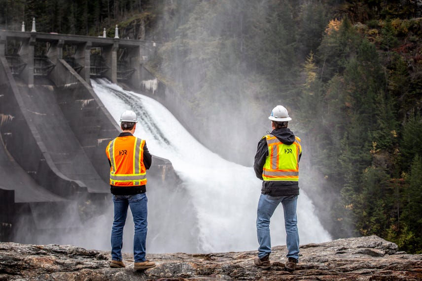
This is Diablo dam in Washington, a 389 foot tall power generating infrastructure that supplies Seattle with electricity Last summer the engineering company HDR took its drones to complement the traditional rope inspections of Seattle City Light.
The result was a two hour flight and more than 82 million data points that document the condition of the structure with its cracks, spalls and other areas in need of repair.
Drones were able to get places that people cant', right?
So drones were able to see things and get to certain areas that a traditional rope inspection might not allowed.
Imagine repelling down a damn going down the rope and trying to report back on I see an issue here and it's a crack and it looks like this and You know, maybe you got a tape measure and you're trying to, get a rough estimate there and maybe sketch out what the crack is looking like.
Versus here's a centimetre accurate model that I can take precise measurements off of and use artificial intelligence to not identify one crack or one potential spalling area but literally overnight.
Run that analysis on thousands of square feet of area of that dam, and generated detailed reports highlighting all of those instances that were found.
Cameron Schafer is the transportation data acquisition lead at HDR.
HDR is a full-service firm that specializes in engineering, architecture, environmental and construction services That has been using drones for the past 3 years.
The program has grown from five pilots to more than 20, who sometimes work with subject matter experts who control the gimbal and the screen and know exactly what they're looking for during each inspection.
In some operations, simple consumer devices may be enough While others require very specialized equipment depending on the nature of the mission and the conditions at the site, the director of data acquisition at HDR Carlos femora explains.
It could be captured with anything from mapic A inspire, you have the into 10 Now you have the Intel Falcon eights or some other types of drones with different payloads you can put on there.
In some of the cases with the dams.
We've done them entirely with drone only.
In certain cases, we want to add other kind of tripods.
There's some cage drones, so I think it ranges from.
In a smaller drones all the way through inspection all the way to the fixed wing, and then there's others that we're looking at in the future as well.
The next question is what happens with all this information?
These databases include a number of different formats that in some cases total well over 100 gigabytes of data.
This data can take between one day and two weeks to process and needs to be delivered in a usable way.
The result is a digital twin, a replica of a real asset that can be updated as conditions change.
It can be delivered through a browser or even a virtual reality environment.
But what makes it unique is its ability to adapt to new information.
The really neat thing where we're starting to see some of these developers go with a digital twin solutions is our is our IoT or internet of things connected devices, you know, say you've got a seismometer Or something that's measuring movement and an asset, anything that's able to capture that data.
You're building on top of this digital twin and you're layering it and it's always collecting more.
It's always changing.
And it's always getting more and more informed.
Here's the digital twin of Diablo dam, a 3d model created from high resolution images, survey data An engineering drawings, the drone captured images where they roughly 60% overlap that the team stitched together through a process called arrow triangulation.
Together with the ground control imaging, they were able to achieve a 2 centimeter accuracy in the plans, that's less than 1 inch.
Now using machine learning and predictive analysis, professionals can anticipate what kind of structural repairs will be needed over time.
And that makes the dam safer in the long run.
That's all for this week.
As always, thanks so much for watching.
I'm your host, Jesse Oro, stay safe out there, everybody.