We're constantly working on new features to make maps more helpful for the more than 1 billion of you who use it every month.
Advances in AI are helping us reimagine what a map can be.
This year alone, we're on track to release more than 100 AI driven improvements, to give people richer and more contextual information.
About the world around them.
Let me share just a few examples.
We've seen how helpful AR can be to see how athletes perform their most impressive feats three years ago, with live view and Google Maps, we were the first ones to use AR at scale to help see where to go.
With signs and arrows overlaid on the real world.
Today, we're still the only company who has AAR navigation maps in more than 100 countries from big cities to rural towns.
So far though liveview has been focused on navigation to help you easily get from point A to point B But now you can also use it to explore the world around you.
You'll be able to access live view right from the map and instantly see details about the shops and the restaurants around you, including how busy they are recent reviews and photos of those popular dishes.
This is possible because we match what your camera sees.
With millions of businesses sharing rich information on Google Maps.
In addition, there are a host of new features coming to live view later this year.
First, we're adding prominent virtual street signs to help you navigate those complex intersections.
Second, will point you towards key landmarks.
And places that are important for you like the direction of your hotel.
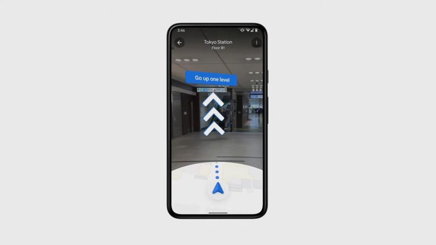
Third, we're bringing it indoors to help you get around some of the hardest to navigate buildings like airports, transit stations and malls.
Indoor live you will start rolling out in top train stations airports in Zurich this week.
We'll come to Tokyo next month.
But AR isn't the only way we're bringing a whole new level of richness to Google Maps.
We've heard from many of you that you'd like to have more granular information about your surrounding That's why we're bringing you the most detailed street maps we've ever made.
Take this image of Columbus Circle one of the most complicated intersections in Manhattan.
You can now see where the sidewalks, the crosswalks, the pedestrian islands are Something that might be incredibly helpful if you're taking young children out on a walk or absolutely essential if you're using a wheelchair.
Thanks to our application of advanced AI technology on robust Street View and aerial imagery.
We're on track to launch detailed street maps in 50 new cities by the end of the year.
Having access to which information is useful but it can also become overwhelming.
So we're making the map more dynamic and more tailored.
Highlighting the most relative information exactly when you need it.
If it's 8AM on a weekday, we'll display the coffee shops and bakeries more prominently in the map.
While at 5pm, we'll highlight the dinner restaurants that match your tastes.
You can see which places you've been to and get more suggestions for similar spots with just a single tap.
And if you're in a new city will make it easier to find those local landmarks and tourist attractions right on the map.
You'll start seeing this more tailored map in the coming weeks.
As you're planning your day, people have found it really useful, especially during this pandemic, to see how busy a places before heading out.
Now we're expanding this capability from specific places like restaurants and shops to neighbourhoods with the feature called area buisiness.
Say you're in Rome, and want to head over to the Spanish Steps and it's nearby shops.
With area buisiness.
You'll be able to understand at a glance if it's the right time for you to go based on how busy that part of the city is in real time.
And as you heard before, we use our industry leading differential privacy techniques to protect anonymity in this feature Area buisiness will roll out globally in the coming months.
So that was a lot.
To recap.
We are expanding our live view capabilities, making maps more detailed and tailored and showing you how busy certain areas are to help you make sense of the world.
All around you.
All of this is possible because of our deep, deep commitment for over 16 years to build the world's most helpful map for people everywhere.
That means mapping roads across more than 60 million kilometers, listing more than a billion buildings, creating a community of over 150 million local guides And finally, applying the most advanced AI technology.
All so you can have the most accurate, comprehensive and detailed map wherever you live in the world on any device, Android or IOS