Facebook uses data to create disease prevention maps
The three maps include data about demographics, mobility and internet access.


- 2022 Eddie award for consumer analysis
Facebook is partnering with more than a dozen nonprofits and universities on this public health effort.
Facebook wants to help public health organizations combat diseases by providing them with a valuable tool: a trio of maps that include data about where people live, how they move and if they have internet access.
The social network used information from publicly available databases and from Facebook's nearly 2.4 billion users to build these maps.
"All of these maps, when combined with information from health systems, can improve the way organizations deliver supplies and respond to outbreaks," said Laura McGorman and Alex Pompe, who work on Facebook's Data for Good team, in a blog post published Monday.
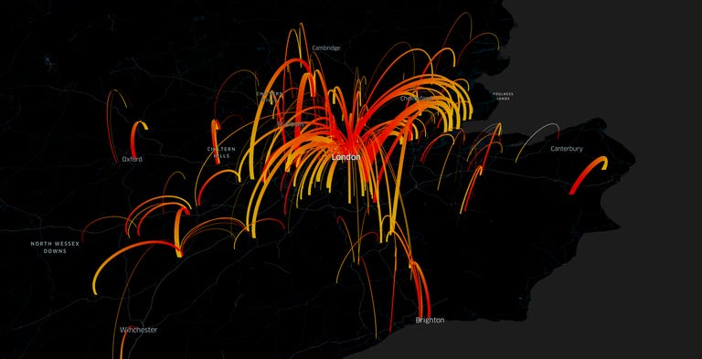
This map shows how people move between London and surrounding areas by day.
One of the maps includes information about the number of people living in a particular area along with data about their age. Harnessing the power of artificial intelligence, the social network used census information and satellite images to create a population map that Facebook says is three times more detailed than any source. The map has already helped the Red Cross decide how to spread out workers who are educating people about getting vaccinated for measles.
Another map, which used data from Facebook users who allowed the social network to track their location, illustrated where people moved. That could help organizations combat contagious illnesses such as the flu that can be spread through human contact.
The third map shows how much internet access is available in a particular area, giving organizations a better idea of whether they can reach someone through online messaging rather than a house visit.
Facebook is partnering with more than a dozen nonprofits and universities on this public health effort, including UNICEF, the Harvard School of Public Health and Direct Relief.