See how wildfire smoke has covered much of the United States
The lower 48 is largely blanketed by hazy, smoke-filled skies as wildfires rage across the West.


I've been noticing strange sunsets lately in New Mexico where the sun looks like a molten ball of red as it sinks into the west. It's one symptom of wildfire smoke in the sky and a dramatic sign of another brutal wildfire season in the US.
The National Weather Service office in Aberdeen, South Dakota, tweeted Tuesday: "You've probably noticed the persistent hazy skies as of late. Turns out we're not the only ones seeing this -- smoke from wildfires is covering much of the lower 48."
Besides apocalyptic-looking sunsets and orange skies, wildfire smoke can impact air quality far from where a fire is actually located. The wildfires, many of which are burning in the Western US, have been fed by severe drought conditions and heat waves. These events have been exacerbated by the climate crisis and the extreme weather it brings with it.
A National Oceanic and Atmospheric Administration smoke model forecast the movement of smoke across the country from Wednesday into Thursday. It shows the great distances wildfire smoke can travel and how wind patterns can push the haze from coast to coast.
Smoke from major wildfires out West is spreading across the country this week, affecting air quality in many regions.
— NOAA Research (@NOAAResearch) July 21, 2021
Here, NOAA's HRRR-Smoke model forecasts the movement of smoke from Wed - Thurs, 7/21-22.
Learn more about HRRR-Smoke: https://t.co/QjzSF2OGdB pic.twitter.com/i7NQkD2U1N
The NWS New York City office shared a hazy view of the city with an orange-tinged sun. "Smoke from the Western wildfires is continuing to invade our skies this morning," the organization tweeted Wednesday.
A happy, hazy hump day!
— NWS New York NY (@NWSNewYorkNY) July 21, 2021
Smoke from the Western wildfires is continuing to invade our skies this morning.
An advancing cold front generates scattered showers and thunderstorms later today, and a few may be severe. Good news is the front helps clear our skies out some tonight. pic.twitter.com/u7jIWmyX3z
A Wednesday NOAA satellite view of the Pacific Northwest showed the smoke rising from 14 large fires across 620,977 acres.
UPDATE: @NOAA's #GOES17🛰️ is tracking a massive amount of #wildfire #smoke across the Pacific NW this morning. According to @ForestServiceNW, there are 14 large wildfires across 620,977 acres of the region. #AirQuality Alerts are also up for parts of Oregon, Washington, and Idaho pic.twitter.com/FQjNqvKRzZ
— NOAA Satellites - Public Affairs (@NOAASatellitePA) July 21, 2021
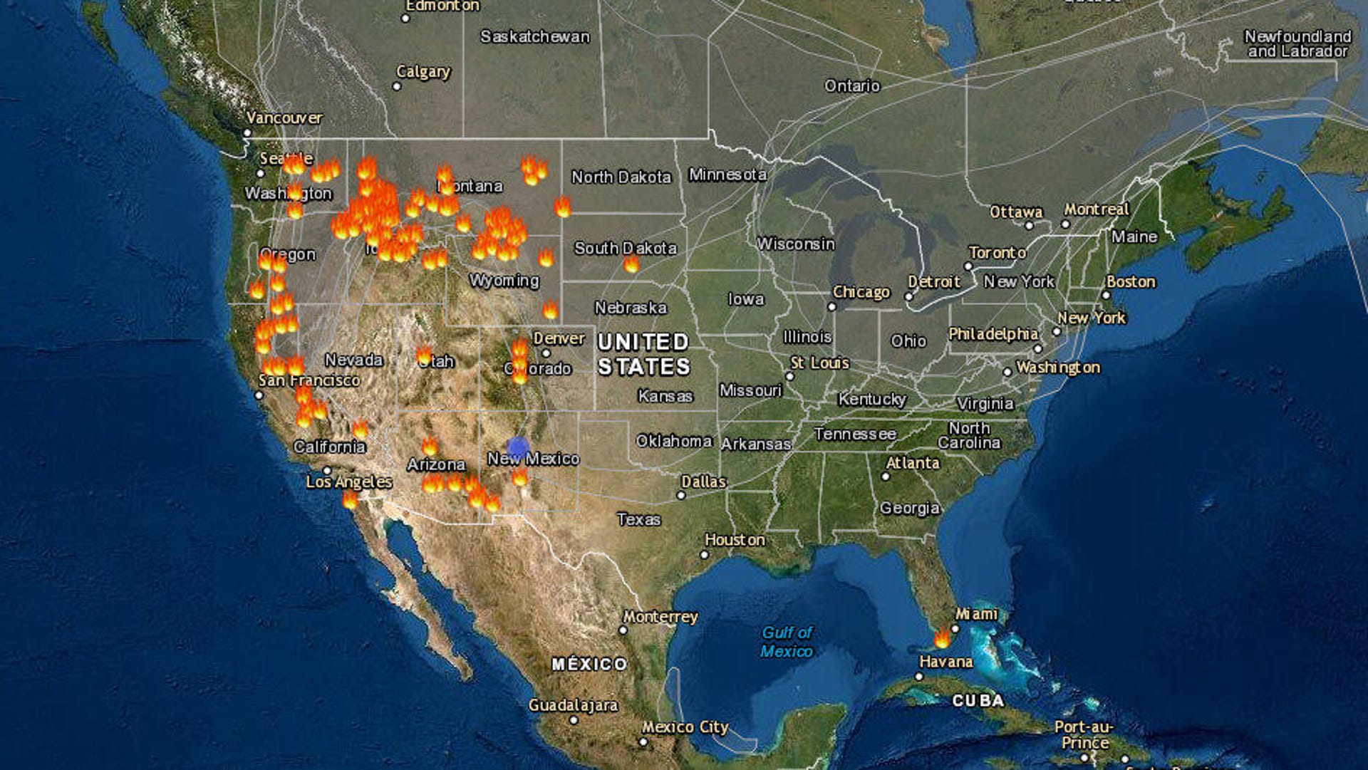
The National Weather Service shared a fire and smoke map from the AirNow air quality monitoring site Tuesday. What's notable are the wide swaths of gray indicating smoke coverage over the US and Canada, as well as the many marked wildfire locations, denoted by the orange fire icons.
You've probably noticed the persistent hazy skies as of late. Turns out we're not the only ones seeing this - smoke from wildfires is covering much of the lower 48. Here's a map from https://t.co/ZMSroBUb5X showing the latest conditions and air quality across the US. #sdwx #mnwx pic.twitter.com/7hHLghPpkI
— NWS Aberdeen (@NWSAberdeen) July 20, 2021
Oregon's massive Bootleg fire is one example of just how bad the 2021 wildfire season is. The fire has burned hundreds of thousands of acres and sent huge amounts of smoke into the air. It's only 38% contained.
NOAA shared a time-lapse look at wildfire smoke spreading from July 15 to 19. The images come from the GOES-East weather satellite. The grayish haze stands out from the white clouds.
It's #TimelapseTuesday, and this imagery from the #GOESEast 🛰️ shows how #wildfire smoke (the grayish-haze compared to the stark white clouds) has been spreading across North America from July 15-19. pic.twitter.com/p2bOMrjNEQ
— NOAA Satellites (@NOAASatellites) July 20, 2021
The smoke may linger. According to the National Interagency Fire Center's Wednesday report, 78 large wildfires have burned 1,346,736 acres across 13 states. Most wildfires are caused by humans, though lightning strikes are another trigger, particularly in remote regions.
This year's smoke-filled skies may feel like deja vu after a devastating year in 2020. If you live in an area where wildfires are a possibility, check out our preparedness guide.