Terrifying Satellite Storm Footage Shows Hurricane Ian Hitting Florida
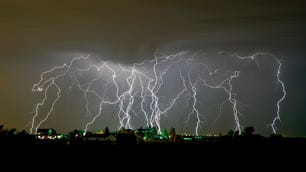
See intense lightning spark around surrounding the dangerous Category 4 storm as it makes landfall in Florida.


- Third place film critic, 2021 LA Press Club National Arts & Entertainment Journalism Awards
Sobering satellite images of Hurricane Ian continue to capture the momentous power of the dangerous Category 4 storm.
NOAA's GOES-16 satellite captures lightning flashes around Ian as it approaches landfall in Florida.
On Wednesday, the National Oceanic and Atmospheric Administration shared a satellite view of the hurricane making landfall near Cayo Costa, in southwestern Florida, with maximum sustained winds at a mind-boggling 150 mph.
Even from space, the storm's churn looks absolutely monstrous, and you can see an extraordinary amount of lightning surrounding it.
.@NOAA’s #GOESEast satellite captured this extraordinary imagery of #Hurricane #Ian making landfall near Cayo Costa, Florida this afternoon.
— NOAA Satellites (@NOAASatellites) September 28, 2022
Latest: https://t.co/0wCH4mn6NI#FLwx https://t.co/FX10iDGu4H pic.twitter.com/01tbXjdgZh
Earlier on Wednesday, NOAA shared a dramatic video from inside the eye of the storm shot by a specially equipped aircraft that flew into its center to gather storm data. On Monday, NOAA space images showed Ian's swirling pattern and reach as it headed toward Cuba and then Florida.
Meanwhile, as Ian batters the Florida peninsula with catastrophic storm surge, winds, flooding and widespread power outages, images from the ground are capturing heartbreaking sights of homes being ripped from their foundations and swept away. Space images shared by NASA astronaut Bob Hines on Wednesday show the size of the storm in relation to the Mississippi River and New Orleans.
This storm is HUGE! That’s the Mississippi River and New Orleans on the left. It covers the entire Florida peninsula! We could see through the eye just as it was making landfall. Praying for the safety of everyone dealing with #HurricaneIan. 🙏 pic.twitter.com/sZZE9gugea
— Bob “Farmer” Hines (@Astro_FarmerBob) September 28, 2022
The storm is expected to weaken as it approaches central Florida. The National Hurricane Center has issued new watches and warnings for North and South Carolina.