New 3D Map of Mars' North Pole Reveals Buried Canyon
A radar-generated view teases out geologic secrets from below the surface of Mars.


Mars' north pole appears in a processed perspective view in this image from the European Space Agency.
Mars' south pole has attracted a lot of attention lately thanks to the unsolved mystery of hidden lakes, but let's not forget the planet's scenic north pole, an icy wonderland that has some secrets of its own. A new 3D radar image of the pole shows what's lurking beneath the surface.
A team of researchers led by Nathaniel Putzig of the Planetary Science Institute used radar data collected by NASA's Mars Reconnaissance Orbiter to create a new polar map. The image is called a radargram. It highlights previously obscured features like an impact crater and a buried canyon.
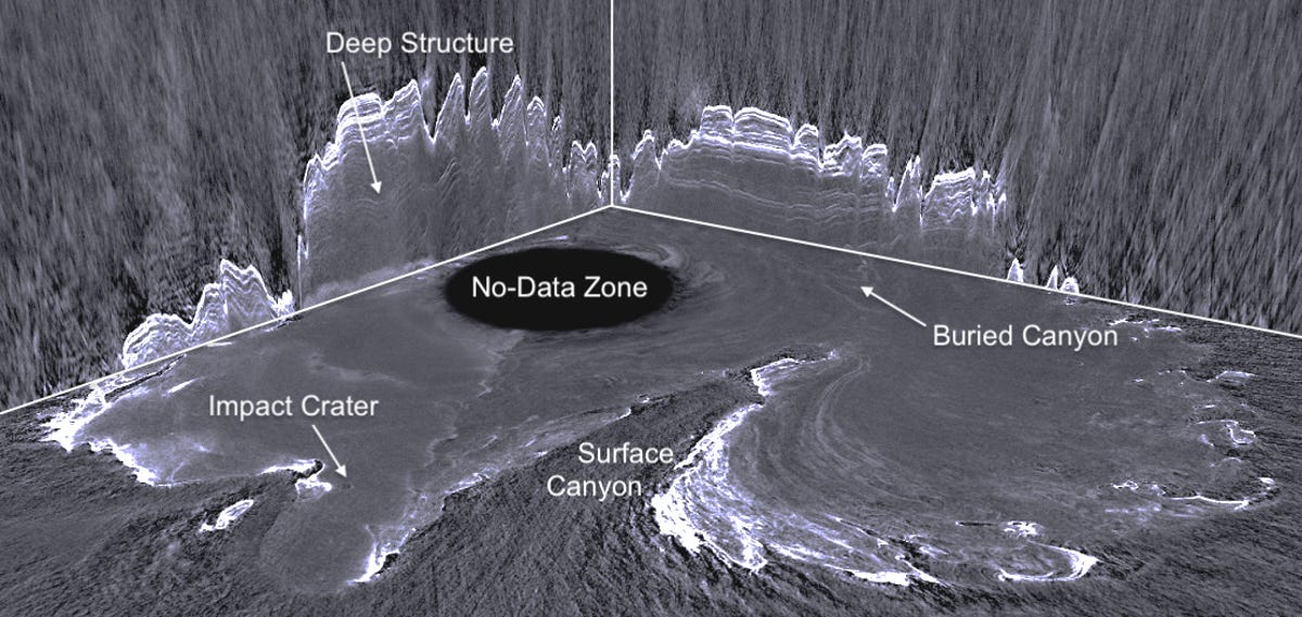

A new radargram shows a map of features at Mars' north pole, including a buried canyon.
MRO is equipped with a Shallow Radar (Sharad) instrument that bounces radar waves off Mars, letting scientists "see" below the surface. The PSI team processed that data into a 3D view of the subsurface. The black oval labeled as a "no-data zone" is an area not imaged by Sharad. The researchers published their work in The Planetary Science Journal on Monday.
Sharad was designed to look for liquid or frozen water, but the reflected radar waves also show what's happening with rocks and sand. It's helping scientists form a picture of how geologic layers have been deposited and eroded at the pole.
A canyon hidden in an icy zone might conjure up Lovecraftian visions, but the radargram isn't about sci-fi horror stories. This is about understanding polar geology and how it connects to the red planet's climate history. Like Earth, Mars is a rocky planet, but it took a very different path to become the inhospitable place it is today.
The 3D map is just the beginning of the tale. Said Putzig, "So far, we have only scratched the surface of understanding what the new data volume is telling us about the history of Martian polar processes and climate, and there is a lot more detailed mapping work to be done."
Next up, researchers intend to identify more buried impact craters and assess subsurface structures that appear in the image. The same process used to create the polar radargram may also be effective in showing what's happening in other regions of the planet. Mars' beauty and intrigue aren't just surface-deep. Clues to its history are hidden below.