NASA images capture extent of Pakistan flooding (photos)
Images from instruments aboard NASA satellites show the devastation caused by massive flooding along the Indus and Kabul rivers in Pakistan.
James Martin
James Martin is the Managing Editor of Photography at CNET.
His photos capture technology's impact on society - from the widening wealth gap in San Francisco, to the European refugee crisis and Rwanda's efforts to improve health care.
From the technology pioneers of Google and Facebook, photographing Apple's Steve Jobs and Tim Cook, Facebook's Mark Zuckerberg and Google's Sundar Pichai, to the most groundbreaking launches at Apple and NASA, his is a dream job for any documentary photography and journalist with a love for technology.
Exhibited widely, syndicated and reprinted thousands of times over the years, James follows the people and places behind the technology changing our world, bringing their stories and ideas to life.
1 of 15 NASA/GSFC/METI/ERSDAC/JAROS, and U.S./Japan ASTER Science Team
Monsoon rains in much of Pakistan
Monsoon rains in much of Pakistan during July caused flooding in tens of thousands of villages across Pakistan, resulting in thousands of deaths and left millions homeless.
More than 16 inches of rain in northern Pakistan in late July has overflowed the Indus and Kabul rivers and displaced millions of people as the high waters have flowed downstream for weeks, destroying thousands of villages and affecting more than one-fifth of the country as the waters flow south where they will eventually empty into the Arabian Sea.
The Advanced Spaceborne Thermal Emission and Reflection Radiometer (ASTER) instrument on NASA's Terra spacecraft captured this image over the city of Sukkur, Pakistan, on Wednesday along the Indus River, Pakistan's longest, which snakes vertically from north to south and is the basis for the world's largest canal-based irrigation system.
2 of 15 NASA/JPL/The Cooperative Institute for Research in the Atmosphere (CIRA), Colorado State University
CloudSat imagery through the storms
On July 28, as the rain began to fall over Pakistan, the Moderate Resolution Imaging Spectroradiometer (MODIS) instrument on NASA's Aqua spacecraft flew over the Pakistan, capturing this image of the bright white thunderstorm clouds that would eventually drop more than 16 inches of rain over the region on July 28 and 29, triggering massive flooding of the Indus and Kabul rivers.
The blue vertical line across the image represents the path of CloudSat at the time the MODIS image was recorded. CloudSat cut through a large thunderstorm cell in the northern section of the country capturing the the 3D vertical structure of the storm along the satellite's flight path, revealing the heavy precipitation.
CloudSat measured the height of the clouds along the radar's flight path at around 15 kilometers at their thickest.
Heavy rain and thick clouds diminished the CloudSat's signal, and the ground echo, the horizontal red line that represents the topography of the area, completely disappears. As the satellite continued to travel north, moving out of the thickest part of the storm and the heaviest rains, the signal improved and the topography was once again visible.
3 of 15 NASA images courtesy the MODIS Rapid Response Team at NASA GSFC.
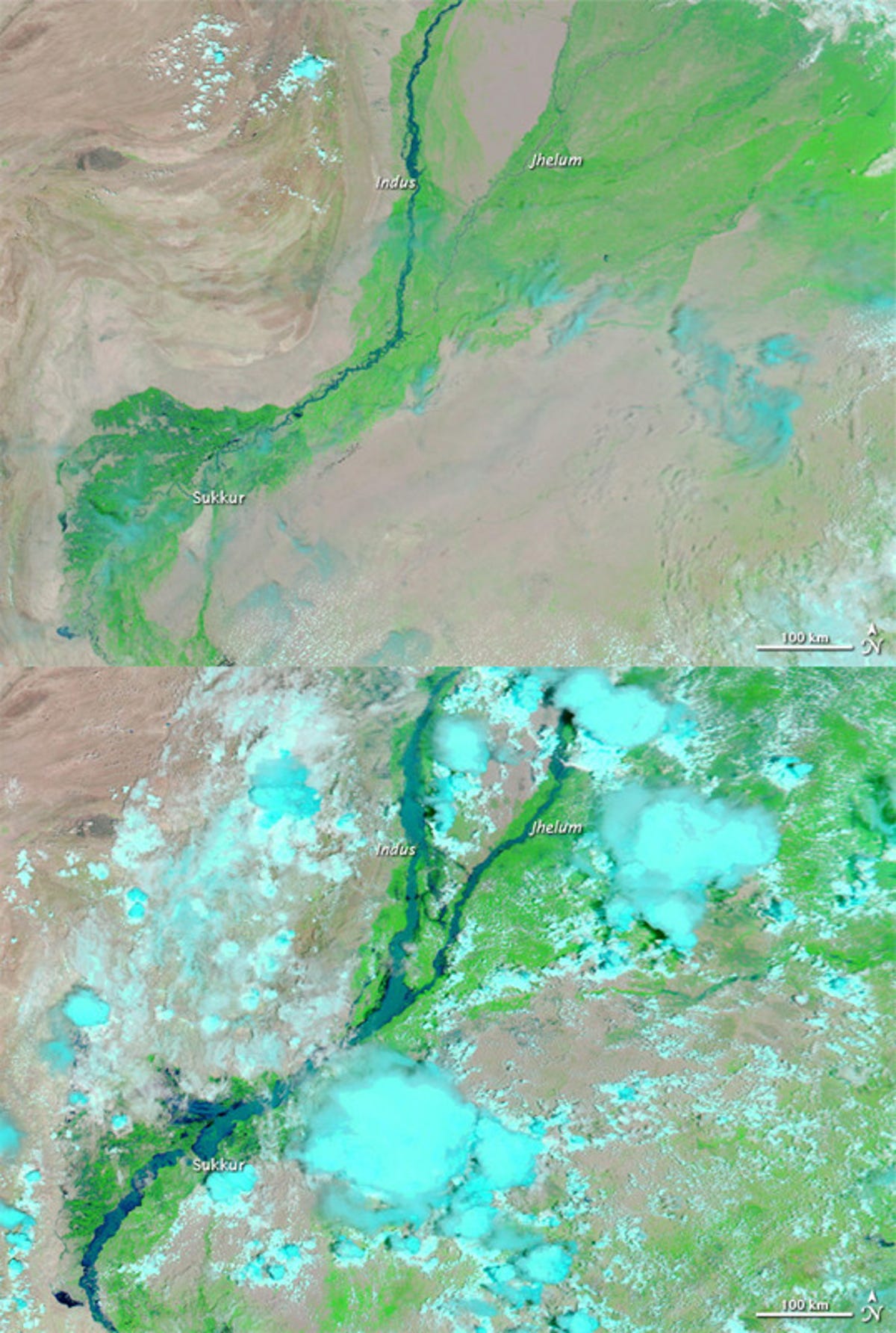
Indus River
The unusually large monsoon season in the north meant that gradually the floods would move downstream along the Indus and Kabul rivers toward its outlet at the Arabian Sea.
The above image taken July 31, 2009, shows the normal state of the Indus River, while the lower Landsat-5 satellite image shows the flood waters on Thursday.
4 of 15 U.S. Marine Corps photo by Capt. Paul Duncan
U.S. Marines, assisting flood victims
Pakistani flood victims take flight aboard a U.S. Navy MH-53E Sea Dragon helicopter that was assisting in humanitarian relief efforts in Pakistan's Khyber-Pakhtunkhwa province on Thursday.
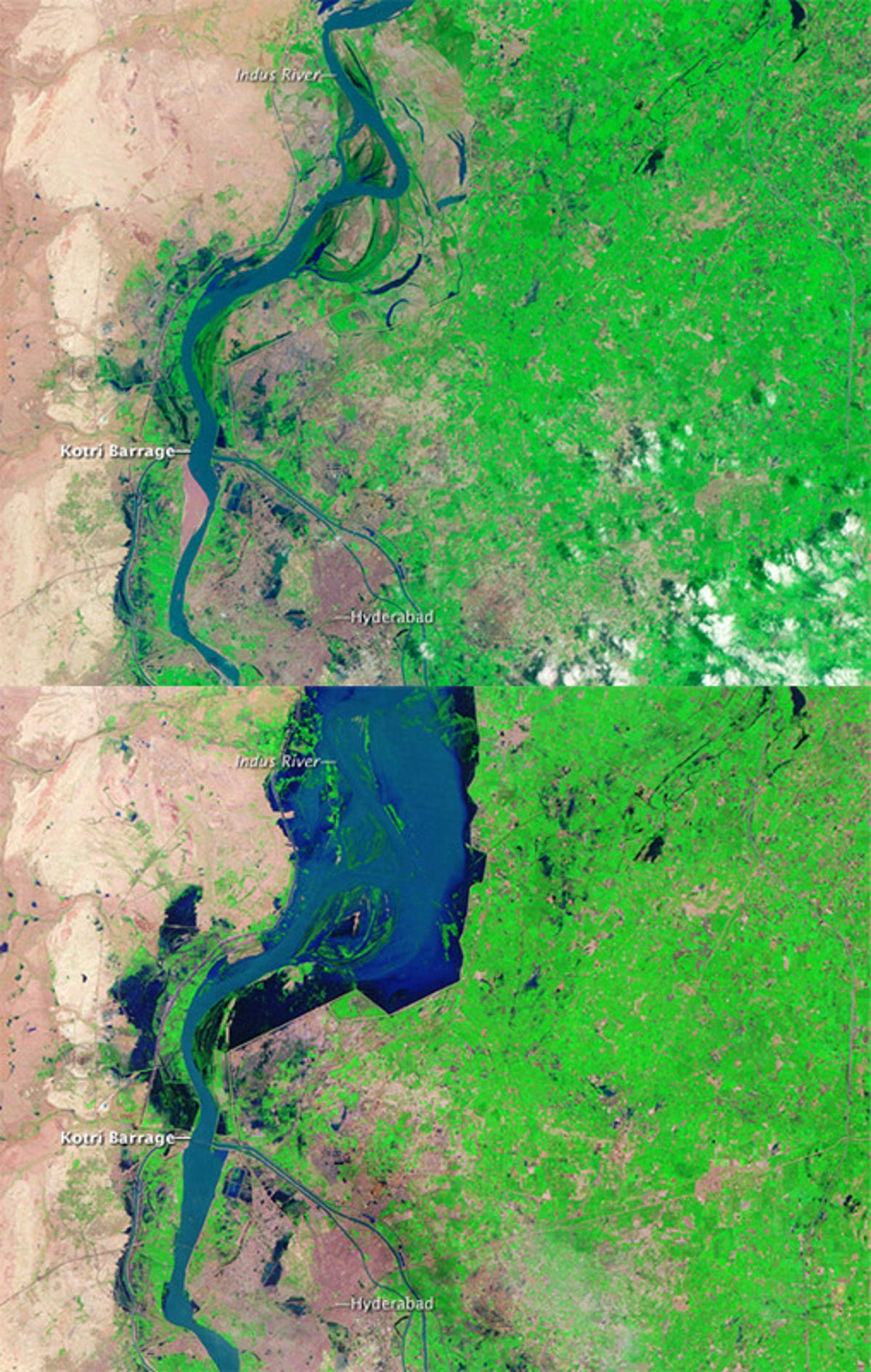
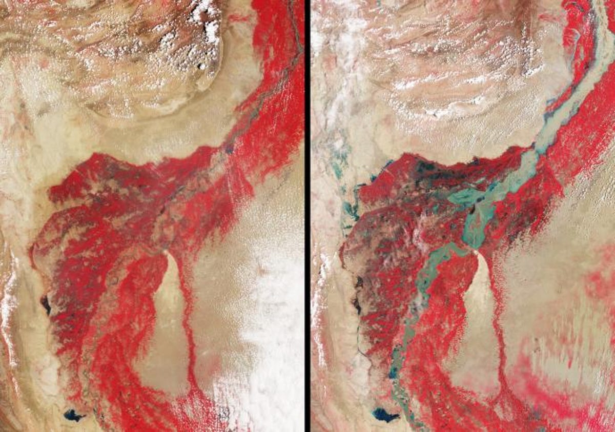
5 of 15 NASA/GSFC/LaRC/JPL, MISR Team
Multi-angle Imaging SpectroRadiometer (MISR)
The Multi-angle Imaging SpectroRadiometer (MISR) instrument aboard NASA's Terra spacecraft captured this false color image of the vast areas of farmland and vegetation--shown in red--that has been affected in the flooding.
In the top image, taken on August 8, 2009, we can see the Indus River as if flows through the Sindh Province of Pakistan, which is typically about 1 kilometer wide has swelled to an astounding 23 kilometers wide or more in some spots in the more recent image taken on August 11, 2010.
6 of 15 NASA/JPL
Advanced Microwave Sounding Unit instrument
Using the Advanced Microwave Sounding Unit instrument, which flies on NASA's Aqua spacecraft as part of the Atmospheric Infrared Sounder (AIRS) instrument suite, scientists use a technique known as surface emissivity to estimate how much of the land surface has been inundated with water by measuring how efficiently Earth's surface radiates heat.
By conducting measurements of the microwave region of the electromagnetic spectrum, we can tell the difference between dry land and area covered with water. Dry land, with a measurement of 1, radiates heat very efficiently, while water, retaining heat better than land, gives a reading of less than 0.5. This image shows that the emissivity has dropped by up to 0.4 in areas surrounding the Indus River, indicating that these areas are almost completely under water.
7 of 15 Robert Simmon, based on Landsat 5 data from the USGS Global Visualization Viewer.
Khewali in southern Pakistan
Compared with the top Landsat 5 image taken August 9, 2009, we can see that by mid-August 2010 the flood waters that began in northern Pakistan had traveled downstream to the city of Khewali in southern Pakistan, covering thousands of acres with muddy water.
8 of 15 U.S. Marine Corps photo by Capt. Paul Duncan
Pakistani flood victims
Pakistani flood victims depart a U.S. Navy MH-53E Sea Dragon helicopter during humanitarian relief efforts in Pakistan's Khyber-Pakhtunkhwa province on Thursday
9 of 15 NASA images courtesy the MODIS Rapid Response Team at NASA GSFC
Punjab and Sindh Provinces
Using a combination of infrared and visible light to increase the contrast between water and land, Moderate Resolution Imaging Spectroradiometer (MODIS) on NASA's Aqua satellite captured these images on August 8.
According to the BBC, the Sukkur Barrage, built in the 1920s to help enable water flow through the local canal system and alleviate famine due to lack of rain, was facing a far greater water flow than it was built to accommodate. Early in the day on August 9, the recorded water flow through this section of the Indus River was up to 1.4 million cubic feet per second, and the barrage was only designed to withstand a maximum of 900,000 cubic feet per second.
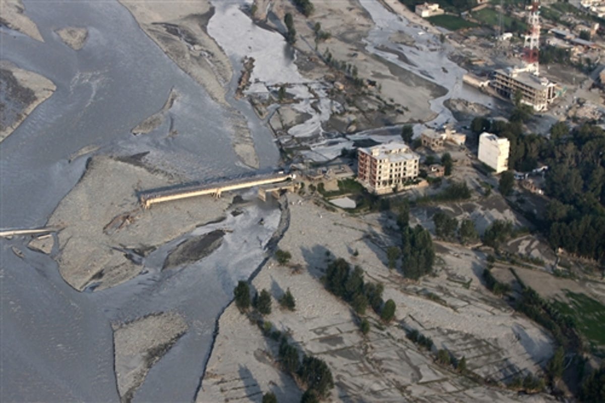
10 of 15 U.S. Marine Corps photo by Capt. Paul Duncan
An aerial view from a U.S. Navy MH-53E Sea Dragon helicopter shows extensive flooding in Pakistan's Khyber-Pakhtunkhwa province on Thursday. The helicopter is assigned to Helicopter Mine Countermeasures Squadron 15, which is involved in humanitarian flood relief efforts.
11 of 15 NASA images courtesy the MODIS Rapid Response Team at NASA GSFC
Moderate Resolution Imaging Spectroradiometer
Thousands of people were evacuated in Punjab and Sindh provinces as the waters continued to rise through August, displacing more than 12 million people and damaging or destroying more than 600,000 homes.
These images of southern Pakistan, taken by the Moderate Resolution Imaging Spectroradiometer (MODIS) on NASA's Aqua satellite, show a dramatic difference in just a few weeks from the top image, taken on July 18 and the resulting flooding which had already reached the southern part of the country by August 8.
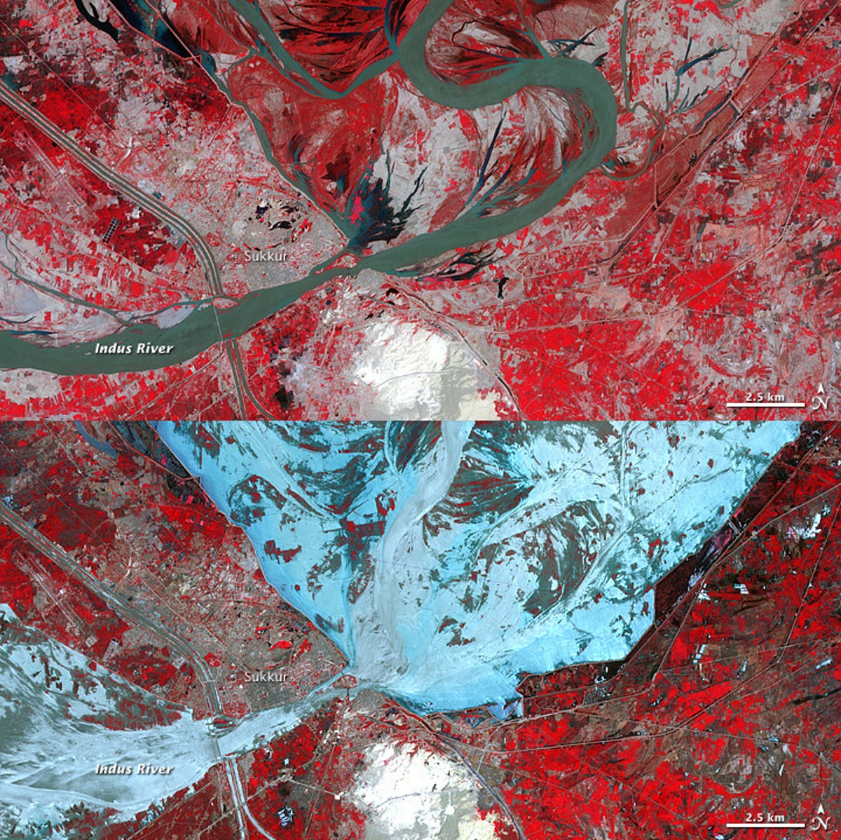
12 of 15 NASA Earth Observatory image created by Jesse Allen and Robert Simmon, using data provided courtesy of NASA/GSFC/METI/ERSDAC/JAROS, and U.S./Japan ASTER Science Team
Advanced Spaceborne Thermal Emission and Reflection Radiometer
As the Indus River comes into Sukkur, the hub of a crucial irrigation network that brings water to farms throughout the Sindh province, we can see that the water, shown in blue in this false color image taken by the Advanced Spaceborne Thermal Emission and Reflection Radiometer (ASTER) on NASA's Terra satellite, have inundated miles and miles of farmland approaching the city.
Compared with the top image, taken in 2001, we can see the extent of the massive damage done to the surrounding areas. Irrigation canals surrounding the city that normally distribute the waters of the Indus River to farms throughout the province have partially protected some of the land by acting as barriers, giving the flood waters a network of outlets.
13 of 15 U.S. Marine Corps photo by Capt. Paul Duncan
U.S. Marines, assisting flood victims
U.S. Marines, assisting flood victims during humanitarian relief efforts in Pakistan on Thursday, evacuate Pakistanis from flood areas in the Khyber-Pakhtunkhwa province.
The Helicopter Mine Countermeasures Squadron 15 is assigned to the amphibious assault ship USS Peleliu to support the Pakistan government in the flooded regions of Pakistan evacuating civilians aboard a U.S. Navy MH-53E Sea Dragon helicopter.
14 of 15 NASA/GSFC/LaRC/JPL, MISR Team
Khyber Pakhtunkhwa, Sindh, Punjab and parts of Baluchistan
This image pair of Khyber Pakhtunkhwa, Sindh, Punjab, and parts of Baluchistan was taken by the Multi-angle Imaging SpectroRadiometer (MISR) instrument aboard NASA's Terra spacecraft. The image on the left is from August 8, 2009, and the one on the right is from August 11, 2010. These false-color images highlight the contrast between the water and vegetation on the river banks, because vegetation appears bright in the near-infrared region of the electromagnetic spectrum.
15 of 15 NASA/JPL
Atmospheric Infrared Sounder (AIRS) instrument
The Atmospheric Infrared Sounder (AIRS) instrument on NASA's Aqua spacecraft, using the instrument's four visible and near-infrared channels, captured these images of southern Pakistan, including the Sindh Province. The Indus River enters from the upper right and winds southwestward toward the lower left.
The image on the left was taken before the flooding began, on July 9 while the image on the right was taken August 10.