Images: How NOAA's tsunami warnings work
NOAA's Pacific Ocean tsunami warning system, expanded greatly in recent years, allowed for real-time forecasting of events and advanced warning for distant at-risk communities after the recent American Samoa earthquake.


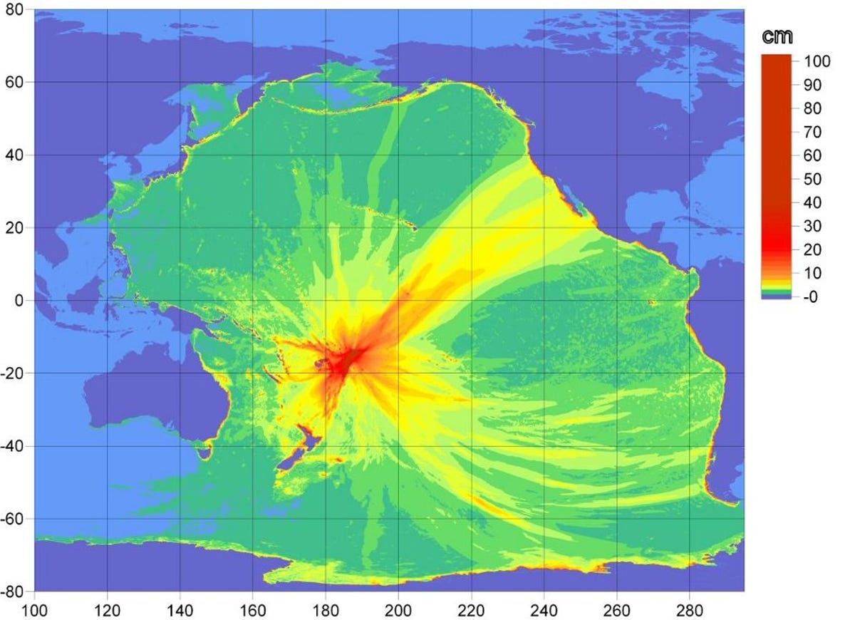
Tsunami propagation map
At 10:48 a.m. PDT on Tuesday, an earthquake with a magnitude 8.0 occurred in the Samoa Islands region. Shortly after, an intricate system of buoys, satellites, and computer networks helped the National Oceanic and Atmospheric Administration get out the word of potential tsunami danger to coastal communities all around the Pacific.
This tsunami propagation map from NOAA shows the height in centimeters of the wave resulting from the quake as it spread across the Pacific Ocean.
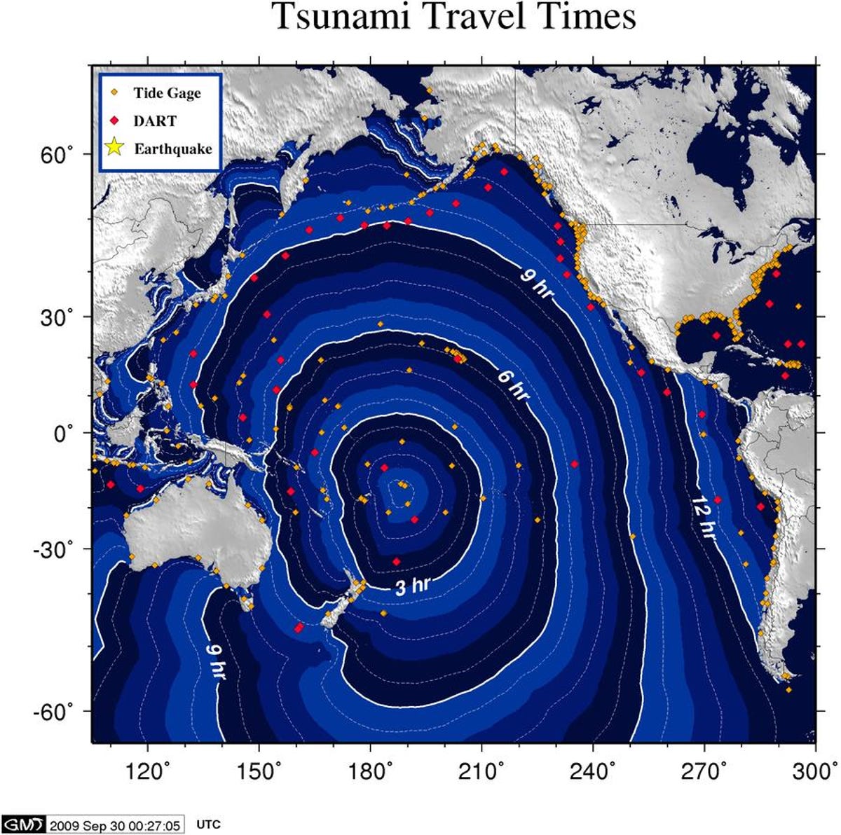
Tsunami travel times
This map shows the travel times of the tsunami wave resulting from the American Samoa earthquake Tuesday.
DART buoys
Tsunami warnings are made possible, in part, by data collected from the Deep-ocean Assessment and Reporting of Tsunami (DART) stations deployed throughout the Pacific Ocean. NOAA began the DART project with an array of six buoys in 2001, and was expanded to a full network of 39 stations in March 2008 (those stations are marked with red diamonds on this map). These real-time data collection points provide advance warning of tsunamis in the critical minutes following a deep sea earthquake.
The DART system, deployable to a depth of 6,000 meters (or 19,685 feet), offers real-time information gathering through its automatic tsunami detection algorithm, or via an on-demand request by the warning center.
NOAA operates two Tsunami Warning Centers in the Pacific Ocean Basin--the Alaska Tsunami Warning Center (ATWC) in Palmer, Alaska, and the Pacific Tsunami Warning Center (PTWC) in Ewa Beach, Hawaii.
The PTWC is a regional tsunami warning center for tsunamis that pose a Pacific-wide threat, collecting real-time data from the buoys and sea floor monitoring systems. The ATWC serves as the regional tsunami warning center for Alaska, Washington, Oregon, California, and British Columbia.
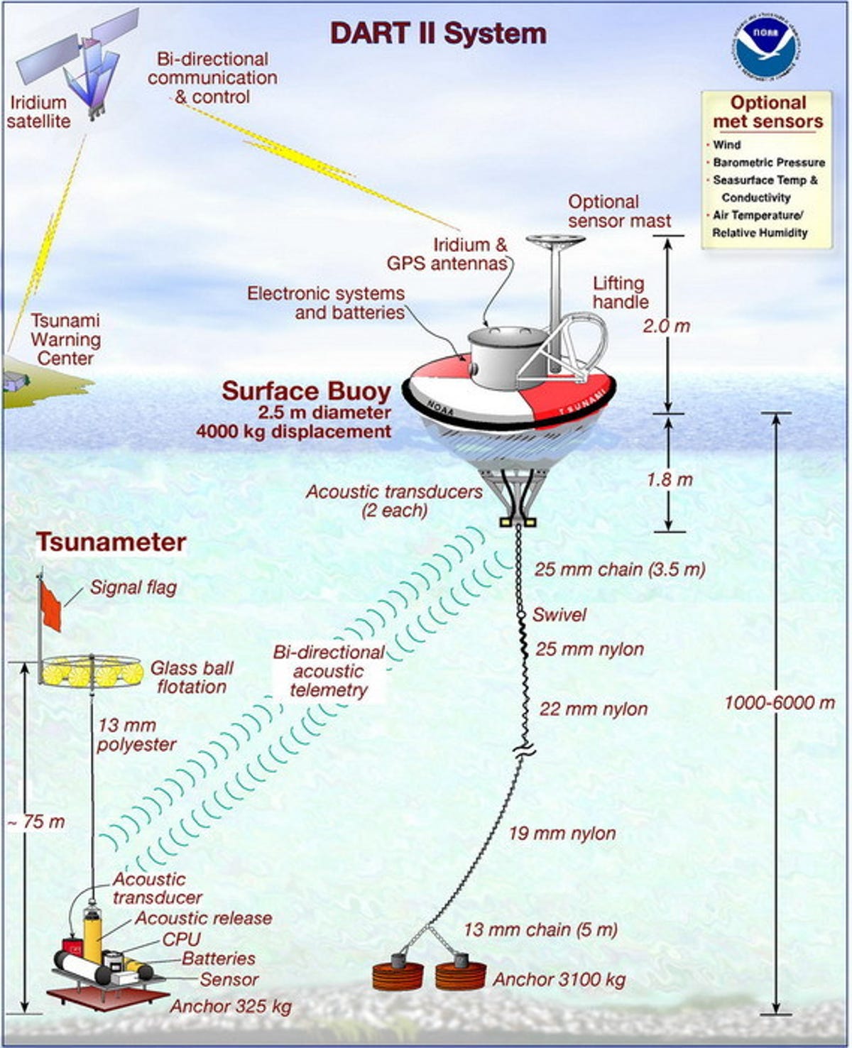
DART II
The DART system is composed of two parts, according to NOAA's Web site: one anchored seafloor bottom pressure recorder (BPR), also known as the tsunameter; and a companion surface buoy. An acoustic link transmits data from the BPR on the seafloor to the surface buoy, and the data is then relayed via a GOES satellite link to NOAA's Tsunami Warning Centers.
Collecting data at 15-second intervals, the system has two data transmission modes. In "standard mode," the second generation DART II system is capable of two-way communication via an Iridium commercial satellite communications system where data is transmitted in 15-minute intervals.
When the buoys' internal detection software detects any changes, the system ceases standard mode reporting and begins "event mode" transmissions, where 15-second values are transmitted during the initial few minutes, followed by updates every one minute.
Once entering event mode, an immediate alert is sent to the buoy, which causes it to turn on the Iridium transceivers for immediate transmission of data to the warning centers. The first Event Mode message contains the exact time that the event was detected, a message ID, the average water column height that triggered the event mode.
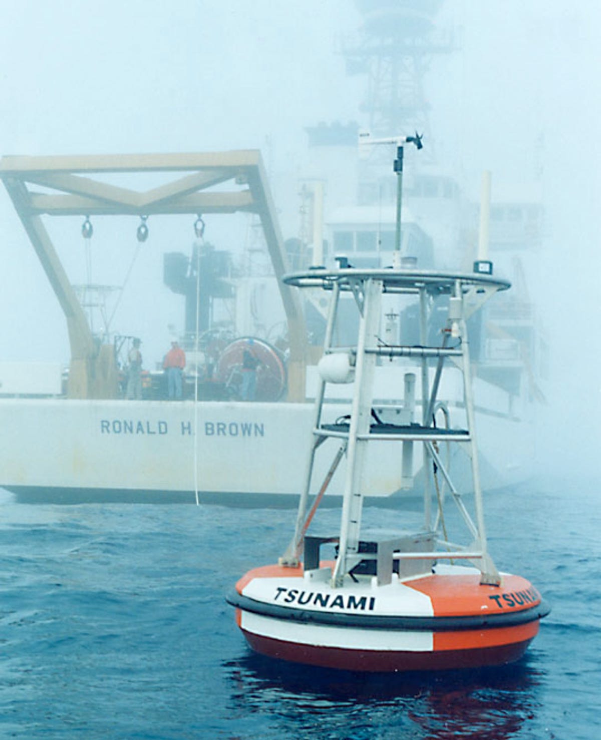
DART buoy
The DART surface buoys are developed by NOAA's Pacific Marine Environmental Laboratory (PMEL) and are constantly being refined to provide more accurate and detailed information.
The first-generation DART design developed by PMEL featured an automatic detection and reporting algorithm triggered by a threshold wave-height value. The system is capable of detecting tsunamis as small as 1 cm.
One of the key advances in software has been in the Tsunami Detection Algorithm. This software monitors the pressure readings and provides automated warning guidance. An important goal for NOAA in the development of all the software tools and tasks has been to keep the total power requirements low.
The DART II design incorporated two-way communications that enables tsunami data transmission on request from the command centers, independently of the automatic reporting algorithm. This capability allows measurement and reporting of tsunamis with amplitude below the auto-reporting threshold trigger. The next-generation DART ETD (Easy To Deploy) buoy is presently under development at PMEL.
More Galleries

My Favorite Shots From the Galaxy S24 Ultra's Camera
20 Photos
Honor's Magic V2 Foldable Is Lighter Than Samsung's Galaxy S24 Ultra
10 Photos
The Samsung Galaxy S24 and S24 Plus Looks Sweet in Aluminum
23 Photos
Samsung's Galaxy S24 Ultra Now Has a Titanium Design
23 Photos
I Took 600+ Photos With the iPhone 15 Pro and Pro Max. Look at My Favorites
34 Photos
