Watching a wildfire hit home--from 5,000 miles away
With satellite data, Facebook, and Twitter, it's both reassuring and scary when a 60,000-acre fire approaches your hometown and the Los Alamos nuclear weapons lab.


- Shankland covered the tech industry for more than 25 years and was a science writer for five years before that. He has deep expertise in microprocessors, digital photography, computer hardware and software, internet standards, web technology, and more.
I'm watching my hometown of Los Alamos, N.M., grapple with yet another massive wildfire, and even though I'm 5,000 miles away, the Internet has given me front-row seats.
It's not pleasant to see--but it's better than the alternative.
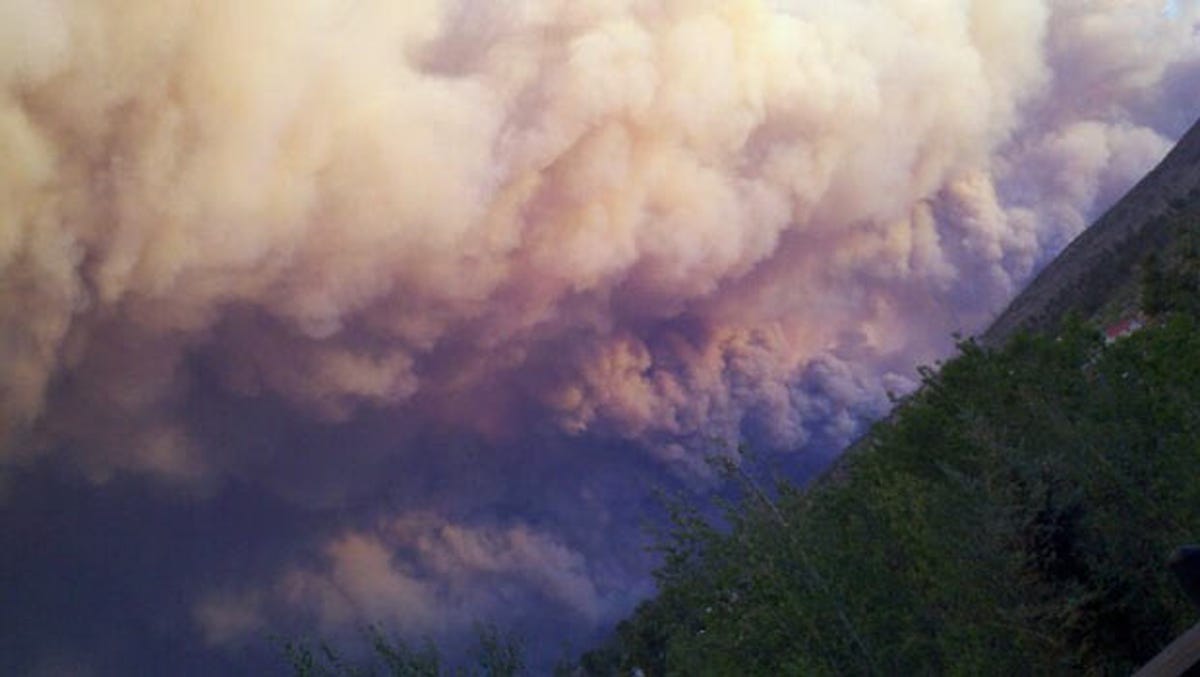
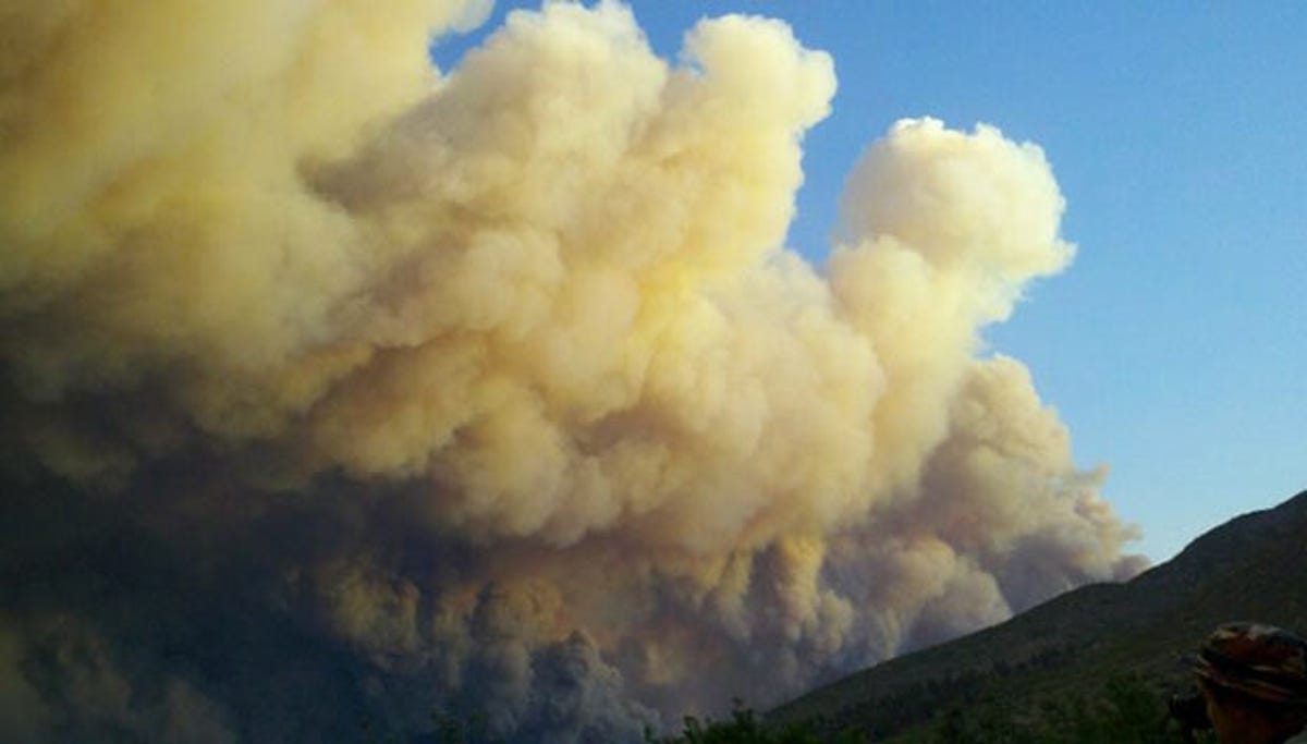
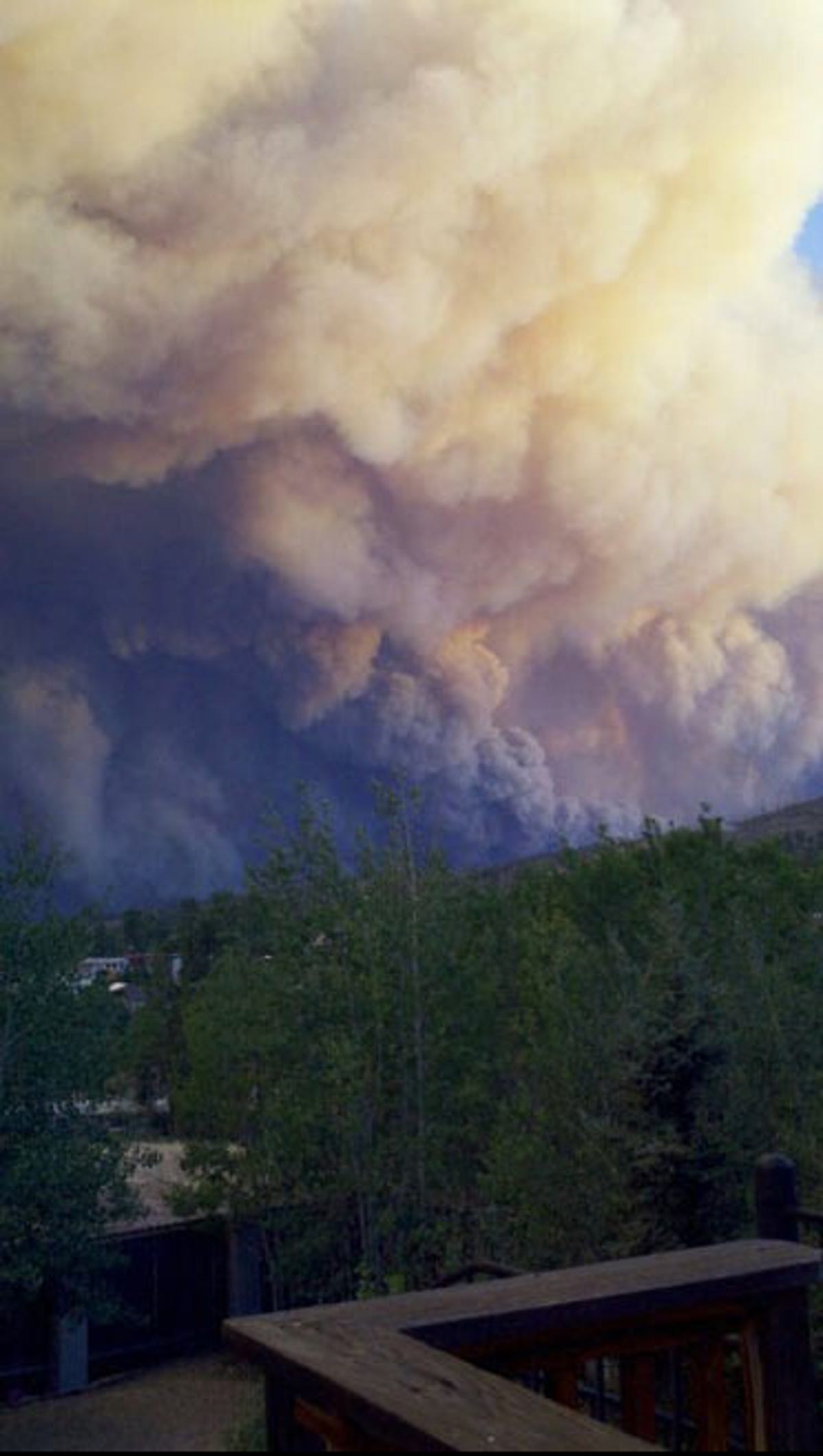
I'm not a member of the ignorance-is-bliss camp, particularly when friends and my parents still live there. The Las Conchas wildfire blew up to a size larger than Washington D.C. when it started on Sunday, and on Tuesday morning it reached 60,740 acres; Los Alamos National Laboratory is closed to all but essential personnel, and two-thirds of Los Alamos County's 18,000 residents have been ordered to evacuate.
I first heard about the fire on Monday morning from my perch in England, which was still Sunday night in New Mexico. It was my morning check of Facebook goings-on that tipped me off.
I've been riveted since--and not just because I care about the people there. I've also been reporting on the fire for CNET News: The fire has brushed up against LANL, a major research institution with thousands of staff and numerous facilities dotted over a 43,000-acre site that's mostly wilderness.
I'm simultaneously amazed at how immediate the Internet has made the event and how short the medium still falls of its potential.
Let's start with the plus side. Facebook has been a source of direct commentary from folks who are seeing this firsthand. That's helped me keep tabs on people whose welfare I'm concerned about, but the collective commentary also has provided information that I couldn't find initially on more official sources. For example, I heard from Facebook friends hours before I heard from the media about a brief moment of rain that, while not enough to extinguish anything, did signify moister conditions that hamper a fire's spread.
Joe Martz, a lab scientist and former classmate of mine from Pueblo Junior High School, stayed put even as the rest of the Los Alamos town emptied out. He's been posting updates about the fire's status on Facebook--and been blasting Rush music at a volume that would deter the neighbors had they stayed, too. He's ready to leave at a moment's notice, relying on the same technology I am to keep his ear to the ground, so to speak.
"Monitoring Webcams and Facebook is far and away the best source of info, followed by the Twitter feed. The old-school media has been slow and without specific enough info to act upon," Martz told me. "Once I lose connectivity, I don't feel safe enough to stay, so I'll leave...My biggest concern is while sleeping if something comes up. Several of us have formed a telephone circle, and we'll call each other if anything warrants to help with this one issue."
Indeed, it's clear smartphones are a tremendous asset if you're affected by a plight like this. You can check e-mail and any number of information sources, but you can also tell others how you're doing and where you are--at least until your battery runs flat or the cell towers are damaged.
Photos are famously effective at communication, too. I've posted a few from Kristi Aamodt Beguin, who was in my beginning French class in 1985 if memory serves. I highly recommend LANL's Flickr photostream for sights that non-authorized personnel aren't likely to see. Its shots show the terrible beauty of a wildfire in an arid area as well as the sobering reality of the evacuation exodus. For video, the Pajarito Mountain Ski Area Webcam was great--until it stopped working for me yesterday.
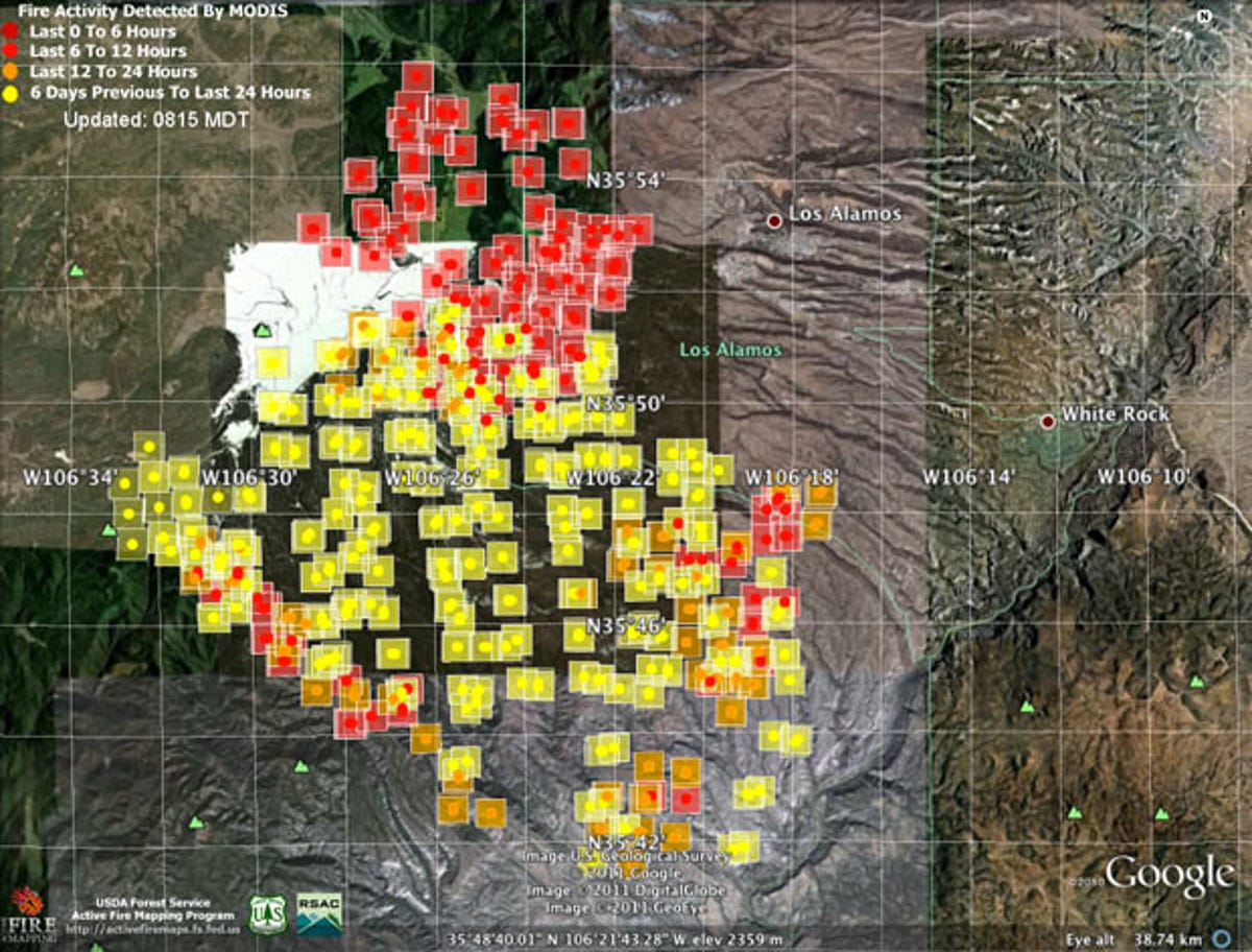
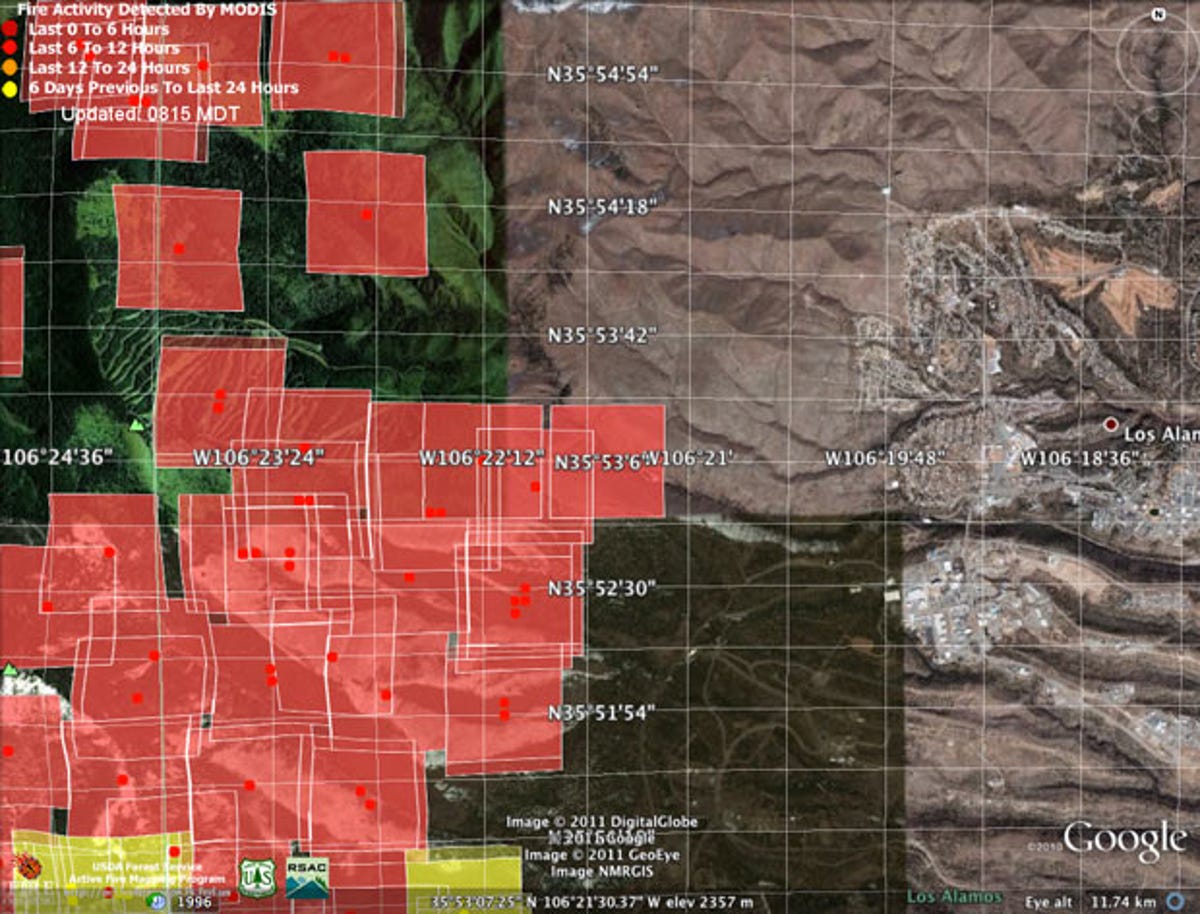
The most surprising find for me was satellite-supplied fire data from the U.S. Forest Service that can be viewed as a KMZ file in Google Earth. I'd heard unofficial reports that the fire had reached Pajarito Mountain Ski Area immediately west of Los Alamos, but I couldn't find official confirmation. The fire data, from NASA's MODIS satellite, confirmed unequivocally that it had, though not with much in the way of detail.
Indeed, the Internet isn't flawless. Local radio station KRSN, already afflicted by a coincidental blown transformer, can only distribute 50 live streams over the Internet at a time.
There are useful official sites: the interagency fire officials' Las Conchas fire site and Twitter feed, the Forest Service's Las Conchas incident page. From them I learned today that fire crews lit burnouts--small, relatively cool fires intended to deprive the main fire of fuel--around the lab's southern edge, and that the number of firefighters on hand has increased dramatically: seven high-end Hotshot crews, 12 ordinary crews, 31 fire engines, three water tenders, five bulldozers, 12 air tankers to drop slurry, and eight helicopters.
Local media outlets, obviously, are another source--the Los Alamos Monitor and the Santa Fe New Mexican newspapers, the KRQE, KOAT, and KOB TV stations.
But all these sites are updated intermittently--today's Forest Service report reports yesterday's fire area, for example, an estimate only two-thirds that of Tuesday's measurements based on an infrared-camera flyover. And the Los Alamos County government has very little on its fire-related site. It's clear that people need to check many sources to keep up.
I'm much better equipped to track the fire from afar than most folks. I have friends and relations there. I have a detailed memory of the mountains and canyons from years of hiking, skiing, cliff jumping, mountain biking, and camping. And I've seen New Mexico firefighting firsthand.
In 1996, as the young science and environment reporter for the Los Alamos Monitor, I covered the Dome Fire as it swept through many of the same regions the Las Conchas fire is burning again right now. I watched the slurry bombers disgorge their vile red fire suppressant, I donned the fire-proof Nomex suit, I got the fire-tent tutorial, I saw the scorched fire engine that was abandoned when surprise flames blew up a hot hillside, I raced down St. Peter's Dome in a Forest Service truck as a post-fire squall flash-flooded with torrents of charcoal-colored mud. I painstakingly created a digital map illustrating the burn area.
Then, after I moved to San Francisco, I watched the Cerro Grande Fire in 2000--the one that burned 235 houses in Los Alamos, including some belonging to friends of mine. Then, too, I got the occasional e-mail, but it paled in comparison to what's available today.
Now I'm even farther away, and there are plenty of things that are different this time: The Cerro Grande scar torched countless trees that otherwise would provide abundant fuel for a fire. Fuel breaks have been improved, particularly around LANL, and emergency planning is more buttoned down. The town has new water tank for fire suppression and experience with evacuation, and the surrounding communities have some experience absorbing that population.
With the Internet, though, the Las Conchas fire for me is mostly a particularly vivid case of deja vu.