New Microsoft Web app showcases vivid aerial pics
Microsoft launches a new application to show off its early efforts to produce high-resolution mapping imagery for the United States and Western Europe.


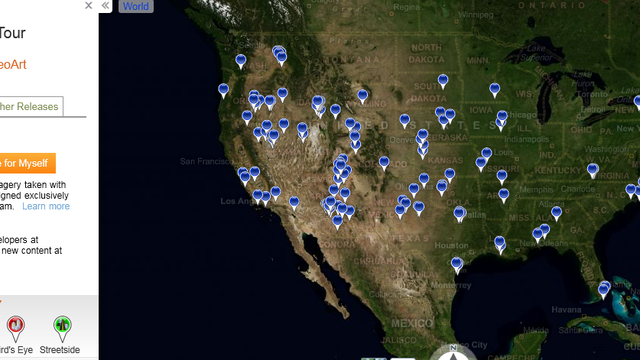
Highlighting efforts to one day provide high-resolution aerial mapping of the world, Microsoft just launched a new Web application that showcases vivid photography of 153 spots around the country.
The detailed bird's-eye views, which Microsoft is calling Bing Maps GeoArt, are part of the company's Bing Maps Global Ortho project, a project to create a high-resolution, seamless mapping mosaic of the continental United States and Western Europe. To achieve the goal, Microsoft is spending north of $100 million, contracting with pilots to fly planes equipped with specially designed $1 million cameras that snap shots every few seconds to capture images where each pixel equals between 6 and 12 inches on the ground.
Then, Microsoft does quality control on the images. It aims to make sure the images are smoke-free and cloud-free, with no non-permanent snow and no standing water. In regions with deciduous trees, it takes pictures during brief periods in the spring and fall when the leaves are off the trees. Then, Microsoft color balances the shots, making sure the images are consistent so users can smoothly scroll across them without ever realizing they're moving from one shot to the next.

The result is remarkably clear aerial mapping that, when Microsoft completes the project, will be consistent as users pan in any direction. Current mapping efforts from Microsoft and rival Google often have images that are most clear in dense urban areas, but much less so in suburbs or rural locations.
Microsoft has turned some of the images into Windows desktop themes that can be downloaded for computers running Windows 7. There are swoopy white sand formations that pop out of the green Gulf of Mexico in Cedar Key, Fla., and reptile claw-looking outcroppings in Canyonlands National Park near Moab, Utah.
Microsoft plans to complete mapping the continental United States and Western Europe by June 2012. Then it will contract with pilots to fly over regions that have changed, such as places hit by natural disasters, to shoot new images. Eventually, the company plans to expand the project to Alaska, Hawaii, Canada, and ultimately the rest of the world.
Right now, Microsoft has captured about half of the United States, though it's only published images for about a third of the country. It's still processing the newer images. And it's shot about 10 percent of Europe.
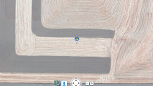
The new GeoArt application wasn't part of the initial plan for Global Ortho. But as the aerial images came in, Microsoft found gems worth sharing.

"It's a really random collection," said Steve Stanzel, general manager, Bing Maps Imagery Technology. "Most often, it's things that are just surprising. The patterns that come out are abstract art."
Some of the most striking are geometric shapes plowed into farmlands, such as the fields east of Pataha, Wash., that Microsoft highlights. There's also a crisp aerial shot of Cowboys Stadium in Arlington, Texas, and a bird's-eye view of Pebble Beach Golf Links along the California coast.

The cost and effort is huge for a product that doesn't have direct returns on the investment. But Microsoft is banking on a halo effect from the Global Ortho project. Between 20 percent and 30 percent of Bing search queries have some local intent, Stanzel said. Microsoft sees the project as a way to compete by providing those Web searchers higher-quality mapping imagery than Google, which stitches together mapping imagery from a variety of sources.
"When people come to Bing and find the information they need, they come back," Stanzel said.