X

How Google slurps in Street View data -- not just from streets

At its Google I/O conference, the company showed off the equipment it uses to gather its 360-degree panoramic imagery of the world.
Stephen Shankland Former Principal Writer
Stephen Shankland worked at CNET from 1998 to 2024 and wrote about processors, digital photography, AI, quantum computing, computer science, materials science, supercomputers, drones, browsers, 3D printing, USB, and new computing technology in general. He has a soft spot in his heart for standards groups and I/O interfaces. His first big scoop was about radioactive cat poop.
Expertise Processors, semiconductors, web browsers, quantum computing, supercomputers, AI, 3D printing, drones, computer science, physics, programming, materials science, USB, UWB, Android, digital photography, science. Credentials
  • Shankland covered the tech industry for more than 25 years and was a science writer for five years before that. He has deep expertise in microprocessors, digital photography, computer hardware and software, internet standards, web technology, and more.
Stephen Shankland
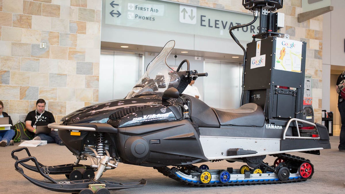
The Street View snowmobile is used to map ski areas. Google had to adapt the technology to keep hard drives warm enough. Google showed the Street View technology at its Google I/O 2013 show developer in San Francisco.
The Street View snowmobile is used to map ski areas. Google had to adapt the technology to keep hard drives warm enough. Google showed the Street View technology at its Google I/O 2013 developer show in San Francisco. Stephen Shankland/CNET

SAN FRANCISCO -- By now Street View is a routine part of online mapping. But people might not be so familiar with how Google actually gets the data for its 360-degree panoramic views of the world.

Street View imagery launched in 2007 with photos taken by cameras perched on cars. That's still the mainstay of the project, but there's much more to it now, and Google was showing off its methods at its Google I/O 2013 developer show here this week.

How Google gets all that Street View data (photos)

See all photos

Exhibits included not just a car, but also a snowmobile, tricycle, backpack, trolley, and self-propelled underwater camera system. The underwater and backpack systems are controlled by Android devices.

For a look at all the gear, check CNET's Street View equipment gallery.

Street View now reaches 3,000 cities, 200 museums, the Great Barrier Reef, and the Grand Canyon.

Although Street View can be convenient for Google Maps users trying to get around unfamiliar territory, it's also important to Google itself. Google uses Street View imagery in its Ground Truth project to correct its own map and navigation inaccuracies.

The standby of the Street View fleet is the car, in this case a Subaru Impreza. Google is showing this one off at the Google I/O 2013 show in San Francisco.
The standby of the Street View fleet is the car, in this case a Subaru Impreza. Google is showing this one off at the Google I/O 2013 show in San Francisco. Stephen Shankland/CNET