Geotagging plug-in shows maturing Lightroom
Lightroom can't match Photoshop for customization and plug-ins, but growing beyond its original abilities. Also, it's getting more popular for editing raw images.


- Shankland covered the tech industry for more than 25 years and was a science writer for five years before that. He has deep expertise in microprocessors, digital photography, computer hardware and software, internet standards, web technology, and more.
Updated 9:03 a.m. PST Nov. 9--See additional information below; the plug-in now can write the geographic data to files.
Jeffrey Friedl, an enterprising photographer and programmer, has released a geotagging plug-in for Adobe Systems' Lightroom, one data point in a trend that shows the image editing and cataloging software is gradually acquiring some of the clout of the more mainstream sibling Photoshop products.
Geotagging is getting easier with cameras such as Nikon's high-end compact camera, the Coolpix P6000, but it's a somewhat onerous process that today requires some technical abilities and sometimes specialized software. Writing the location metadata into digital photo files pay off later, though, for example by letting you see on a map just where you took that vacation photo or look up pictures by typing in the name of the city where you took them.
Frieldl's Lightroom geotagging plug-in reads a GPS unit's track log, then deduces a photo's location based on the time it was taken. Although that's the same basic mechanism many other geotagging programs employ, Friedl's plug-in brings some welcome flexibility to the process by moving the process within Lightroom.
More broadly, it shows that third parties are making Lightroom a more useful, customized tool. Another example are the wealth of downloadable editing "presets" that accelerate processes such as whitening subjects' teeth or brightening a dark foreground that's been overwhelmed by a bright sky. However, Lightroom still has nothing like the level of add-ons of Photoshop.
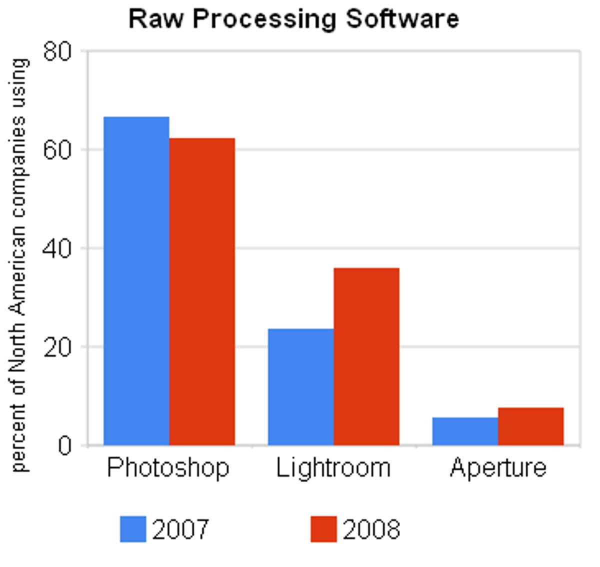
A survey by market researcher InfoTrends shows the gradual acceptance of Lightroom for its core ability, editing the raw images from high-end digital cameras. Professional photographers and enthusiasts like raw images for the flexibility, but unlike JPEGs, raw images must be processed by software such as Photoshop, Lightroom, or Apple Aperture.
InfoTrends asked what software North American companies use to process raw images in 2007 and again in July 2008. Lightroom increased in usage from 23.6 percent to 35.9 percent, while Photoshop declined from 66.5 percent to 62.2 percent, according to a blog post by Lightroom product manager Tom Hogarty. Aperture, available only on the Mac, increased from 5.5 percent to 7.5 percent.
Lightroom limits
One of Lightroom's advantages is that all changes made to photos are nondestructive, meaning that unlike many Photoshop effects they can be reversed. The approach also means the changes can be saved as a small set of editing instructions stored in the image's metadata, along with captions and camera information. But one drawback of the nondestructive approach is that it limits the variety of plug-ins Lightroom can accommodate.
But Adobe is gradually expanding the software's abilities. With Lightroom version 1, one of the few ways to expand the software's abilities was with an export interface--an interface Friedl used to build a Lightroom plug-in for exporting photos directly to Flickr, Smugmug, and Picasa. With Lightrom 2, Adobe added a metadata interface that lets programmers add customized metadata to images. It's that ability that let Friedl build the geotagging plug-in.
But for now, though, Lightroom stores only the metadata in its catalog, not writing the changes to the actual image file or to an accompanying XMP "sidecar" that can house an image's metadata. (XMP, short for Extensible Metadata Platform, is an Adobe creation that sidesteps complications of storing metadata in proprietary raw image file formats.)
That limitation means Friedl's geotagging records only "shadow" GPS coordinates. That's still useful, though, since Lightroom users can set the software to embed the real metadata when exporting images as JPEG or uploading them to a Web site, for example, but it's not as good as writing it into the file.
But Adobe expects eventually to enable that ability, Hogarty said in an interview.
"Storing custom metadata in the Lightroom catalog is only the first step, and the ultimate goal is to embed the custom metadata in the XMP metadata block," Hogarty said.
It's not going to happen at a breakneck pace, though. "I can't speak to specific timeframes for when that functionality would be part of the Lightroom API (application programming interface), but I will say that any metadata implementation requires a great deal of consideration and testing," Hogarty said.
Update 9:03 a.m. PST Nov. 9: A newer version of Friedl's plug-in now can write the metadata into files so it's not just carried as shadow GPS data, Friedl said in an e-mail.
"It's still more kludgey than it needs to be, but now at least it's possible to upgrade the shadow data to 'real' GPS data," Friedl said. For raw images, the plug-in writes the metadata to an accompanying XMP sidecar, he said. The updated plug-in uses the ExifTool open-source software package to handle the writing.
"Lightroom still doesn't know about that data, so...you have to do a sync," he added, meaning that a photographer must command Lightroom to read in the geographic metadata. "It's pretty silly that one has to go through these gyrations, but that's how it is. I hope 3.0 will be better."
The plug-in also includes some support for reverse geocoding, which converts latitude-longitude coordinates into the actual names of cities and countries. It uses a new Google interface for the service. Reverse geocoding in general can make it easier for people to search for photos based on their location.