Curiosity discovers how water shaped the landscape of Mars
Much like how the flow of water on Earth carved out the shape of the land, so too did it sculpt the surface of Mars, once upon a time.


There is no longer any question: water is present on Mars -- albeit only in the form of ice or vapour. Today, the questions that remain concern liquid water: was the planet's H2O ever in a liquid state and, if so, did it flow on the surface, or was it confined to subterranean locations?
New evidence found by Curiosity in the Gale Crater suggests that not only did liquid water flow on the planet's surface, it did so for long enough to build up Mount Sharp in the form of sediment deposits -- over a period of tens of millions of years. The finding suggests that lakes and rivers existed in many locations all over Mars.
"If our hypothesis for Mount Sharp holds up, it challenges the notion that warm and wet conditions were transient, local, or only underground on Mars," said JPL curiosity deputy project scientist Ashwin Vasavada. "A more radical explanation is that Mars' ancient, thicker atmosphere raised temperatures above freezing globally, but so far we don't know how the atmosphere did that."

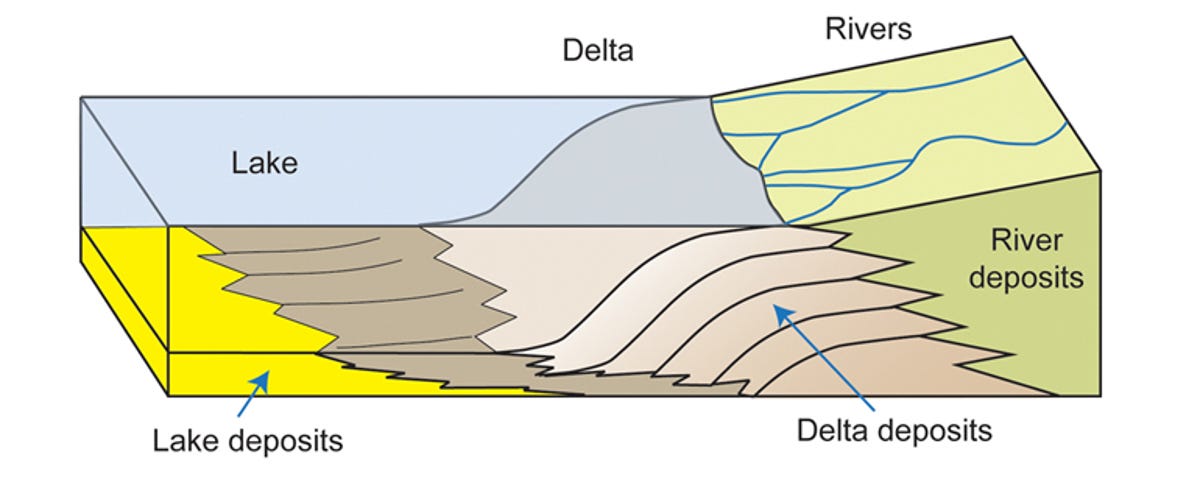
Mount Sharp is a mountain that stands about 3 miles (5.5 kilometres) high in the centre of the Gale Crater -- an unusual landscape formation. On its lower flanks, Curiosity has imaged the sedimentary layers, which alternate between lake, river and wind deposits, indicating a lake that filled, evaporated and refilled many times over.
The lowest of these layers, a section of rock 500 feet (150m) high, is the one currently under investigation. It bears similarities to delta formations on Earth, where rivers carry and deposit sand and sediment to the mouth of the river. As the centuries passed, the sedimentary deposits hardened into rock. This was, in turn, sculpted by wind erosion; and this changing shape was observed by Curiosity as it made the 5-mile (8km) trek from its landing site to the base of the mountain.
"We found sedimentary rocks suggestive of small, ancient deltas stacked on top of one another," said Curiosity science team member Sanjeev Gupta of Imperial College in London. "Curiosity crossed a boundary from an environment dominated by rivers to an environment dominated by lakes."
Exactly what climate conditions on the red planet could have been warm and stable enough for sustained periods of liquid water on the surface are still unknown. However, NASA hopes its research will be able to help understand conditions under which Mars could support human habitation.
"Knowledge we're gaining about Mars' environmental evolution by deciphering how Mount Sharp formed will also help guide plans for future missions to seek signs of Martian life," lead scientist for NASA's Mars Exploration Program Michael Meyer said.