Coming in 2008: GPS-enabled cameras?
The founder of GPS chip designer Sirf Technology believes some cameras next year will know where they're taking photos, partly through new technology that can get a location fix faster.


- Shankland covered the tech industry for more than 25 years and was a science writer for five years before that. He has deep expertise in microprocessors, digital photography, computer hardware and software, internet standards, web technology, and more.
The year of the GPS-enabled camera is nearly upon us.
So predicts Kanwar Chadha, founder of GPS chip designer Sirf Technology. "Most (camera makers) are seriously planning location-enabled cameras. The first," he said, "you'll see next year."
Chadha has a vested interest in the technology, so take that bullish prediction with a grain of salt, but don't discount his expertise, influence, and connections. And do pay attention to a new technology Sirf is developing that Chadha promises will let GPS devices find their location within 10 seconds of being switched on.
If his prediction comes true, it'll be good news for those of us who want to know where our pictures were taken as well as when.
Adding location data to photos--a technology called geotagging--is potentially useful, though some are worried about privacy implications. For one thing, you could find out where some particular photo in your archive was taken, which could be handy after your European vacation recedes into the past and all those cathedrals start blurring together. For another, you can give guided slideshows based on a map rather than a timeline. And having location data is another way of searching for photos of a particular subject.
"A location stamp is much more important than a time stamp in most cases. A year down the road, you have no idea where those pictures were taken and no way to search for location," said Chadha, who is Sirf's vice president of marketing. I'm not sure if I agree which I'd rather do without, but I would prefer to have both.
Combining the widespread use of geotagged pictures data with photo-sharing sites gives a new dimension to privacy concern: you'll have to be more careful if you don't want people to figure out where you live or your children play, for example. No doubt that could be a problem for some people, though no doubt law-enforcement agencies will love it for forensics purposes, but it's not an issue I'd get overly alarmed about.
For one thing, people will get gradually more used to the risks of public disclosure, just as they've had to for Web site postings, blogs, MySpace pages, corporate e-mail--and photo sharing as it stands today. I wouldn't be surprised if geotagging is an option you can disable in your camera, and photos-sharing sites such as Flickr and Smugmug let you keep location information private if you choose. Flickr won't even capture the information unless users specifically enable it.
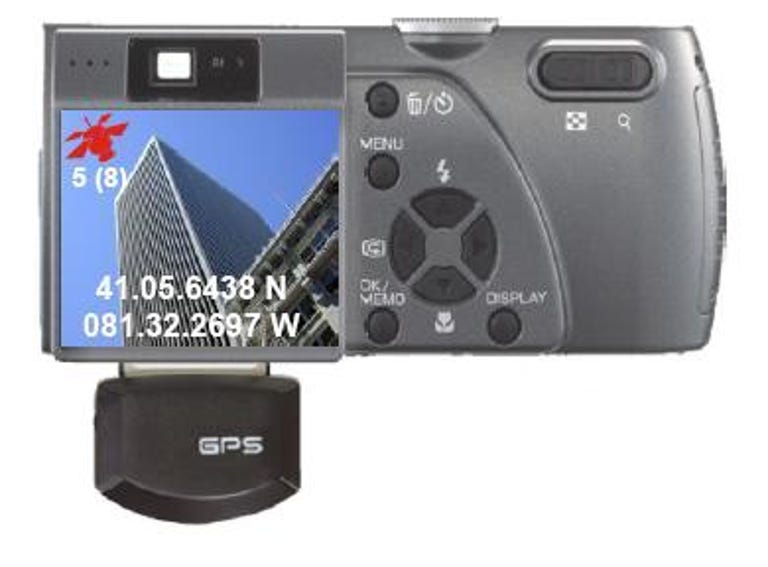
But geotagging is technically challenging, typically requiring that a photographer use a PC to merge photos with location data copied from a GPS receiver. Building GPS receivers into the camera would sidestep that unpleasantness and be a significant step toward an autotagging future in which the camera adds useful metadata to photos automatically.
Based on my experience with GPS receivers, which judge location based on signals received from orbiting satellites, I was skeptical when Chadha made his 2008 prediction during an interview earlier this month.
One problem is that GPS receivers, which generally stay switched on all the time when in use, require a lot of power, whereas cameras automatically shut off to conserve it.
And if you do switch the GPS unit off to save power, there's a different problem: when you switch it back on, it takes a long time to pinpoint its location--a wait called "time to first fix." New GPS units typically take 30 seconds under the best of conditions to During that wait, the photographer might well have moved on, and the wait can last a lot longer if the satellites are obscured by trees, buildings, or other impediments.
But Chadha described technology Sirf is just unveiling that could get around the power-on, power-off problem. The basic idea is that a GPS system can simplify and speed up the process of finding its position by calculating where in the sky satellites are at a given time.
The technique lets a GPS system can find its location within about 10 seconds, Chadha said.
Software on the GPS device runs the calculations, but it must be synchronized with a PC or network service to get updated, accurate satellite position information, Chadha said. Orbital details such as friction with the Earth's atmosphere make the actual performance of the satellites harder to predict with computer models.
For a device such as a camera with limited computing horsepower, the model could run about two or three days before fresh satellite location data was needed, but a more powerful personal navigation device can go five to seven days.
"I don't believe anybody else has this kind of technology," Chadha said.
Ricoh sold a camera with an add-on GPS module, and Canon and Nikon higher-end SLR cameras can accommodate them. But so far GPS integration is rough at best. We'll check back a year from now to see if Chadha's prediction comes true.