California's fires face a new, high-tech foe: Drones
These eyes in the sky may become firefighters' best tools for combating one of the worst wildfire seasons in state history.


- Webby Award honoree, 2x Gold Telly Award winner

This is part of our Road Trip 2018 summer series "Taking It to Extremes," which looks at what happens when people mix everyday tech with insane situations.
Smoke is billowing from a five-story window. In between those thick plumes, I know there are two people trapped inside — but I can see only one.
How do I know there's a second person? From a thermal image that's being livestreamed from a drone. Thanks to the video's clear picture of who's inside the room, incident command instructs a firefighter to climb the ladder and make the rescue.
Fortunately, this isn't a real fire. It's a demonstration at a Menlo Park Fire District station in California, showing a crowd of firefighters how new drone imaging technology can help search and rescue operations. In the heart of Silicon Valley, Menlo Park is perfectly situated to test new technology. It's also received donations from Facebook to buy drones and thermal cameras.
The timing of the demonstration couldn't be more apt. It's fire season in California, and thousands of firefighters are battling blazes across the state, like the mammoth Mendocino Complex Fire that's already torched nearly 423,000 acres and the Carr Fire, which has so far destroyed 1,600 structures and claimed seven lives.
To help win their war against wildfires, state and federal departments are turning to drone missions for reconnaissance and data gathering. The California Air National Guard, for example, is using a military grade UAV (unmanned aerial vehicle), called the MQ-9 Reaper, at both the Mendocino Complex and Carr fires. The drone captures live video of the blaze from 20,000 feet and can stay in the air for hours, identifying where the fire is spreading.
No matter if they're small quadcopters or larger fixed-wing drones, UAVs are becoming an invaluable tool for firefighters to safely identify threats and reduce exposure to dangerous conditions. Some are equipped with lidar technology, which uses pulsed light to measure distances and generate precise, 3D fuel maps that show where fires are most likely to spread.
The Menlo Park Fire District was one of the first in the US to start a drone program. In the four years since, more than 180 fire departments across the country have bought drones for fire and rescue operations. Relatively few have pushed drone usage to the same level as Menlo Park, which has set up a dedicated drone command center and which trains firefighters from around the country to pilot the aerial devices.
These eyes in the sky can navigate tight spaces and fly lower than helicopters can. With them, crews can see objects in the path of a fire, areas of intense heat and even people trapped in areas of thick smoke. Last year, the Menlo Park team flew drones equipped with thermal cameras to help battle the South Fork Fire in Yosemite National Park. The images showed crews when a fire had jumped a containment line and helped them steer clear of dangerous conditions, like weakened trees and intense heat.
"How guys get killed is weather changes on a dime, sometimes there's no real warning," says Tom Calvert, Menlo Park Fire's battalion chief. "By having a drone, your sphere of awareness gets a lot bigger."
Send in the drones
Menlo Park Fire Capt. Chris Dennebaum walks me through the tech room at the back of the station. It's filled with cameras, TVs, chargers, an assortment of batteries and what I'm really here to see: the drone collection. The department has almost every consumer DJI drone, including the small Mavic Pro , which you can have in the air within minutes after unfolding its arms. There's also the larger Phantom 4 (the most popular drone flown in the US) used for training and mapping missions.
Then we get to the serious flying machines that not only capture images but can also carry a payload. The DJI Matrice 210 and 600 hold up to 10 pounds — so anything from cellphones to LED lights to radios to life preservers can potentially be dropped to people who need them.
These larger drones can also carry impressive camera systems. One camera, for instance, boasts 180x zoom, while the DJI Zenmuse XT2 has two eyes in one: a thermal module to see areas of heat through smoke, and a regular 4K camera. The capability lets pilots lock onto the hottest object in the frame, or add the regular video image on top of the thermal image.
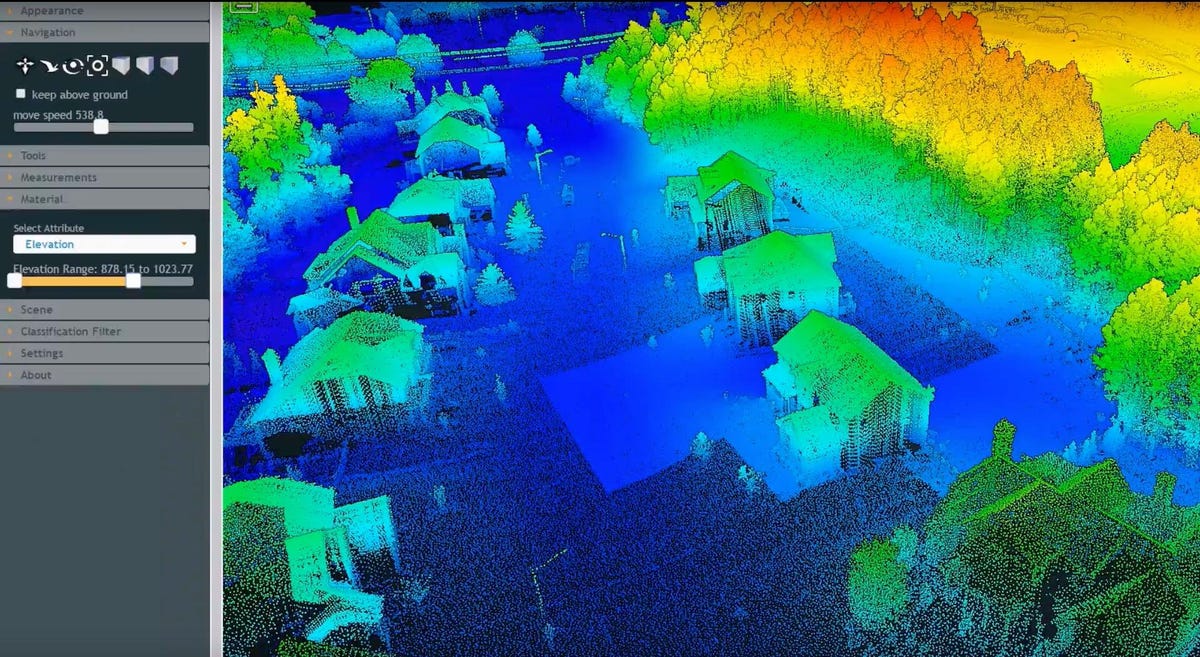
Lidar can produce detailed images of power lines, poles, trees and other potential fire hazards along the power grid.
"Flying with just thermal imaging active means the pilot can quickly lose depth perception," says Dennebaum. That's why it's helpful to be able to toggle between the views or overlay one on top of the other.
Menlo Park is also building a mobile drone command center that'll allow the crew to pilot several aircraft at once and view data across multiple screens. The command center can also provide the public with real-time video updates about areas that've been destroyed, spared or remain in danger.
Spreading like wildfire
More than 170 wildfires burned 245,000 acres in Northern California last October. Cal Fire blamed 12 of those fires on PG&E's "electric power and distribution lines, conductors and the failure of power poles" — when tree limbs fell on power lines. PG&E rebuts this. "Based on the information we have so far, we continue to believe our overall programs met our state's high standards," the company said in a statement.
Many utilities are turning to drones to mitigate fire threats, often with the help of San Diego-based Flight Evolved, which uses lidar-equipped UAVs to build 3D maps that reveal potential fire starters along the grid. San Diego Gas & Electric and Southern California Edison, for instance, use these 3D maps to see if power lines are sagging in extreme weather or if poles are decaying and need replacement.
"It can be used for a lot of structural engineering analysis to determine where things are in their relation to trees, vegetation, houses or potential issues that might cause fire hazards," says Flight Evolved owner David Ilgenfritz.
Something different
Fire departments and universities are also exploring new ways drones can fight ever-worsening wildfires. In Colorado, the Center of Excellence for Advanced Technology Aerial Firefighting (part of the state government), is trialing a system that sends live drone footage straight to firefighters' phones.
Using a mapping engine originally developed by the Air Force called ATAK (Android Team Awareness Kit), crews can track each other's position and see real-time data on the fire itself. The mapping system gives everyone a clear picture of who's doing what and where they're located, as well as critical weather information.
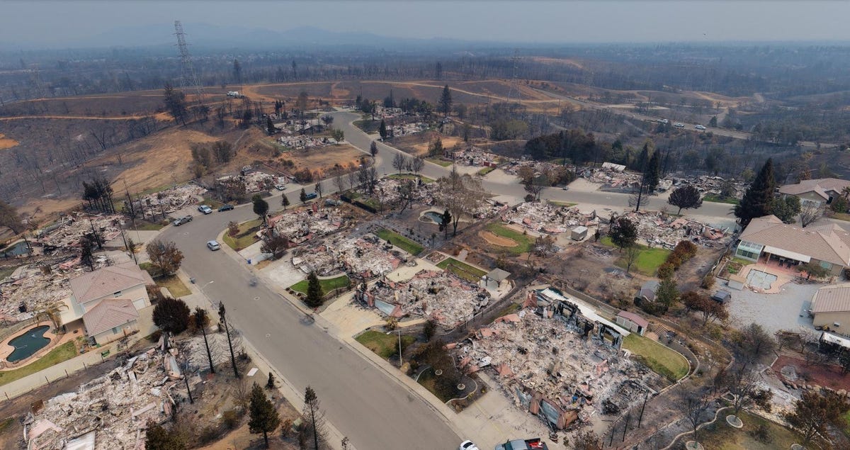
A drone shot of the devastation left by the Carr Fire.
That's great where there's mobile coverage, but that's not always a given.
"The challenge with ATAK is it runs great on the phone, but if you can't connect one firefighter to the next, it really doesn't make sense," says Ben Miller, the center's director. One of the tools the center is testing to create network coverage is a GoTenna Pro, a small stick firefighters can use to make an ad-hoc mesh network.
Miller's group eventually hopes to use something called a pseudo satellite: solar-powered, fixed-wing UAVs flying at 60,000 feet and transmitting broadband to expand internet access or replace downed infrastructure like cell towers.
Sky pilots
I'm sitting in a drafty warehouse a few miles from the Menlo Park fire station, where firefighters are training to fly drones indoors. It's a challenging environment even for experienced pilots: They have to fly in a confined, poorly lit space marked out with nets and traffic cones.
Hobbyists generally fly drones on days with little wind, no rain and good lighting. Firefighters rarely get to pilot their drones in similar conditions.
"First responders are trained to deal with any type of stress very quickly and appropriately, but this is new technology," says Romeo Durscher, director of public safety integration at DJI.
Relatively few fire departments have the resources to run their own drone training program.
That's where Skyfire Consulting's two-day training comes in. The course brings fire crews up to speed on everything from managing airspace to advanced maneuvers. Skyfire has taught more than 120 departments across the US, including the San Francisco Bay Area cities of Fremont and Redwood City.
Once students nail down the actual piloting, they move on to other challenges, like interpreting data to spot potential hazards and to determine where fires will most likely spread. It's a tough ask, because the pilot's brain has to alternate between flying the drone line-of-sight, watching the camera image on the control screen and working out what's actually happening in the frame.
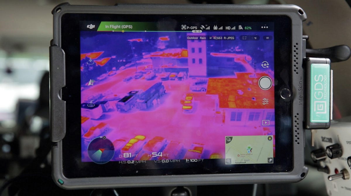
This thermal image taken by drone shows an area's hot spots.
Augmented reality could reduce this heavy mental load. One example is the free First Response app from Edgybees, designed for police, fire and local governments. With it, geographical data such as power lines, street names and team locations gets overlaid on top of the camera's video image. That gives pilots a clear, single-source view of potential issues or hot spots without needing to cross-reference another map.
Over time, the augmented view from Edgybees could be integrated into ATAK to combine communications and situational awareness. Edgybees was used last year in rescue operations during hurricanes Harvey and Irma and the Northern California wildfires.
"Having UAVs out on these incidents is gonna be the new way we're doing business," says Calvert. "It has a value you just can't deny anymore."
Drones also play an important role after the fire's been put out. During the Carr Fire, crews piloted low-flying drones to capture 360-degree images of the destruction. For the residents forced out of their homes, this provides invaluable information on property damage to help insurance claims.
Withstanding the heat
Drones are a lot more rugged than you might think. If one crashes, you can often change out propellers or plastic components, and the drone's good to go for another flight. If you accidentally fly directly into smoke, you just use Q-Tips to clear out carbon built up inside the aircraft.
Click here to see more Road Trip adventures.
But this doesn't mean they don't run into some fire-specific problems. Dense smoke can sometimes knock sensors and cameras for a loop. Dennebaum tells me about a drone that sensed smoke as a solid object, triggering the collision avoidance system.
Then there's battery life. While some larger drones can fly for up to 40 minutes, maneuvering in high winds or carrying a payload can significantly cut flight time. Still, this restriction may have a bright side: It gives pilots the mental break they need to help them refocus.
Drones offer an unparalleled perspective for firefighters to spot threats. But the real potential is yet to come. Fire crews could deploy swarms of drones to get different views of the same fire, or send up drones with water tanks to complement traditional aerial firefighting tools, such as helicopters and planes.
"This sounds like a Jetsons future," says Durscher, "but I think this is really around the corner."
The Smartest Stuff: A look at the people working to make you — and the world around you — smarter.
Life Disrupted: Reporters' dispatches from the field on tech's role in the global refugee crisis.