Beirut explosion: Sobering satellite views show widespread devastation
Planet Labs and Maxar have released before-and-after images of the Aug. 4 disaster.


A tragedy unfolded in Beirut, Lebanon, on Tuesday when a massive mushroom-cloud-generating explosion shattered the port city. New images from satellites above show the scope of the devastation.
At least 100 people died and thousands were wounded in the explosion, which leveled buildings and could be heard as far away as Cyprus. Survivors shared videos online showing the destruction from ground level.
Satellite imagery companies Planet Labs and Maxar Technologies posted before-and-after views of the Beirut port area to Twitter on Wednesday.
Planet Labs shared SkySat images from May 31 and Aug. 5. The difference is stark. Large sections of the port are damaged or entirely missing. A cruise ship lies on its side in the center-right of the image.
Before and after SkySat imagery shows the impact of yesterday’s explosion in Beirut.
— Planet (@planetlabs) August 5, 2020
Imagery captured on May 31, 2020 and today, August 5, 2020. pic.twitter.com/8zCLDOZn4w
A stockpile of ammonium nitrate stored at the port for years appears to have caused the major explosion. An investigation is ongoing to understand the full sequence of events that led up to the catastrophe.
Maxar released a GIF with a close-up look at the port before and after. It brings home the overwhelming power of the explosion.
Before and after images from the #explosion that happened in #Beirut, #Lebanon on August 4, 2020. Before image from June 2020 and after image from today, August 5, 2020. More imagery showing the devastation will follow. pic.twitter.com/dfj4ItyTXL
— Maxar Technologies (@Maxar) August 5, 2020
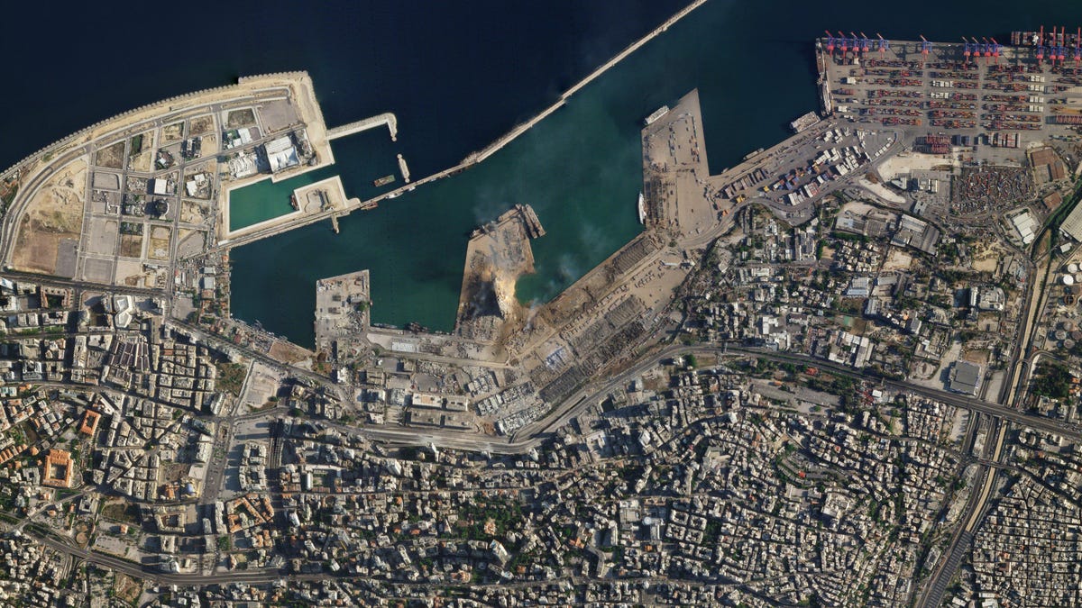
Maxar then shared a series of even more detailed satellite images of the port and surrounding areas. "Take a look at the large crater, the capsized Orient Queen and buildings with blown-out, shattered glass," the company wrote.
See the incredible damage from the #Beirut, #Lebanon explosion in these high-resolution #satellite images taken on August 5, 2020. Take a look at the large crater, the capsized Orient Queen and buildings with blown-out, shattered glass. pic.twitter.com/OxgzmZKNwR
— Maxar Technologies (@Maxar) August 5, 2020
Beirut now faces intense challenges in the aftermath of the explosion as overwhelmed hospitals care for the wounded. Hundreds of thousands of people may have lost their homes.
The satellite images are just one way to comprehend the magnitude of the calamity. "Beirut is a destroyed city," reported CBS News producer Sami Aouad.