Don't walk out into Hurricane Dorian's eye, authorities warn
The National Hurricane Center is urging residents of the Bahamas to quit taking videos and instead take shelter and stay there.


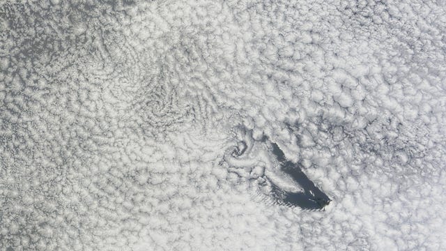
NOAA shared this satellite view of Dorian before it ramped up into a Category 5 storm.
It's a dangerous combination. People want to capture video of extraordinary experiences to share online. They also get a false sense of security when the calm eye of a hurricane passes through. But it won't stay that way for long.
The National Hurricane Center responded on Twitter to videos from the Abacos island group in the Bahamas that showed up on social media on Sunday. The videos came from residents who ventured out into the eye of Hurricane Dorian, a raging Category 5 storm that is kicking out maximum sustained winds of 180 mph.
IMPORTANT: We have seen videos in the Abacos of people venturing out in the eye of #Dorian. Everyone should take shelter immediately as winds will increase rapidly and unpredictably after the eye passes.
— National Hurricane Center (@NHC_Atlantic) September 1, 2019
One of the videos from Sunday showed wreckage spilled across the ground. "Everyone should take shelter immediately as winds will increase rapidly and unpredictably after the eye passes," the National Hurricane Center warned.
The only people who really have business venturing into the eye of a hurricane are the National Oceanic and Atmospheric Administration's Hurricane Hunters. These brave professionals fly a plane into the hurricane to gather data to help with forecasting the storm.
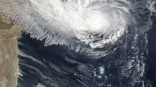
The National Hurricane Center posted an epic photo from inside Dorian on Sunday. You can see part of the Hurricane Hunter aircraft and a view of the "stadium effect" within the eye. This can happen with powerful storms like Dorian and gets its name from the clouds forming high walls that make it look like you're in the bowl of a sports stadium.
Here's a look at what scientists call the "stadium effect" inside the eye of #Dorian from @NOAA scientists. This happens at times in very strong hurricanes. The latest forecast on Dorian is available at https://t.co/tW4KeFW0gB pic.twitter.com/Knv6w7nXP6
— National Hurricane Center (@NHC_Atlantic) September 1, 2019
Hurricane Dorian has gained strength over the last few days. It has also shifted its path several times, making it hard to predict where exactly it might impact the East Coast of the US. Florida, Georgia and the Carolinas are all under alert. The Bahamas are currently taking the brunt of Dorian as of Monday.
The FCC said Monday has been working with wireless carriers in the southeast to prepare for emergency situations as Hurricane Dorian nears Florida. The agency said it's implementing lessons learned in the wake of Hurricane Michael -- a 2018 Category 4 storm that tore down electrical wires and ripped apart fiber networks needed for delivering broadband and mobile phone service in Florida.
NASA, NOAA and astronauts on the International Space Station have been tracking Dorian from orbit. Webcams located in the Bahamas, Florida and Carolinas have their eyes on the ocean, giving us a sobering view from ground level.
The National Hurricane Center's advice for staying out of the eye goes for anyone who is experiencing a hurricane. No Twitter or Facebook video is worth putting yourself in that kind of danger.
This story was originally published Sept.1 at 12:54 p.m. PT
Updated Sept. 2 at 12:25 p.m.