Images: Social media takes on Mother Nature
A look back at recent natural disasters shows a strong role played by emerging technologies, particularly in the aftermath.


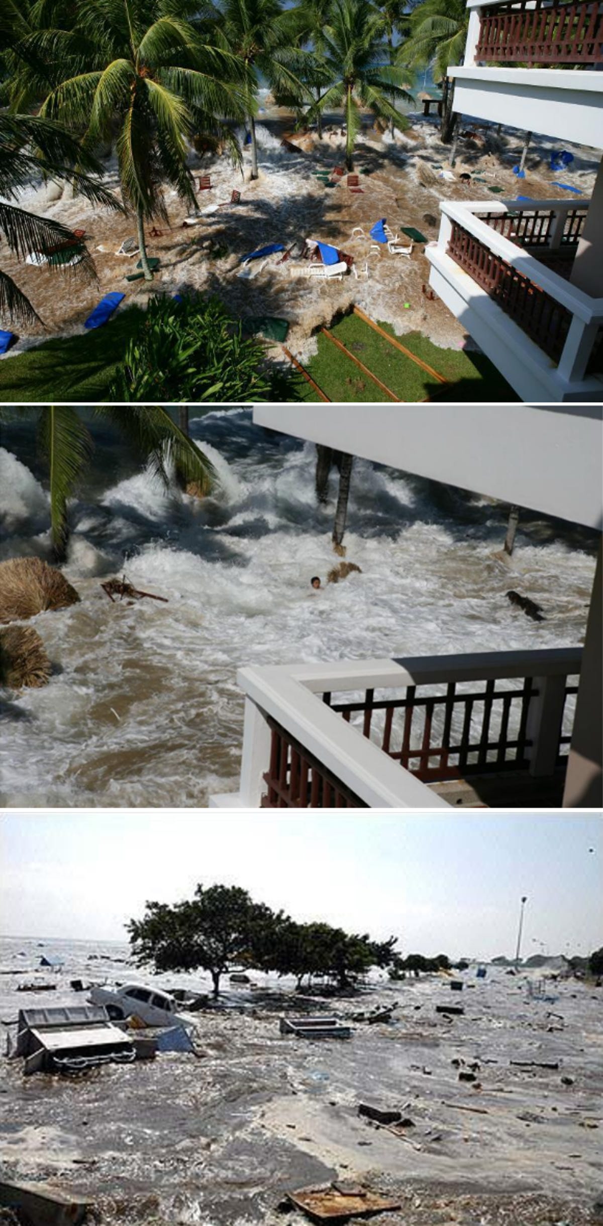
Indian Ocean tsunami (2004)
Natural disasters can occur at any time, and often without any warning. As technology moves forward, humanity has created new ways to share and display information. We've put together a small list of major disasters in recent history, and how emerging technologies have played a role in the days that followed.
When 2004's Indian Ocean earthquake led to a massive tsunami that struck most of Indonesia and Sri Lanka, one of the first places people could find photos and videos of the disaster was the Web. YouTube was inundated with short clips showing waves slamming over beaches and into the swimming pools at five star resorts. Likewise, photos snapped by phones and digital cameras were being uploaded to Webshots, Flickr, and other online photo hosts.
As for relief efforts, more than 50 contributors put together The South-East Asia Earthquake and Tsunami Blog, which aggregated news and set up a tracker for missing persons reports and humanitarian efforts. The site saw a huge surge in traffic shortly after the disaster, and became a go-to place for survivors to share their stories and information.
Another thing to come out of this disaster was new technology for warning people of incoming tsunamis ahead of time. Three undersea sensors called Deep-ocean Assessment and Reporting of Tsunamis, will fire off information to satellites and warning centers that can send out SMS alerts in case it picks up on signs of an incoming tsunami.
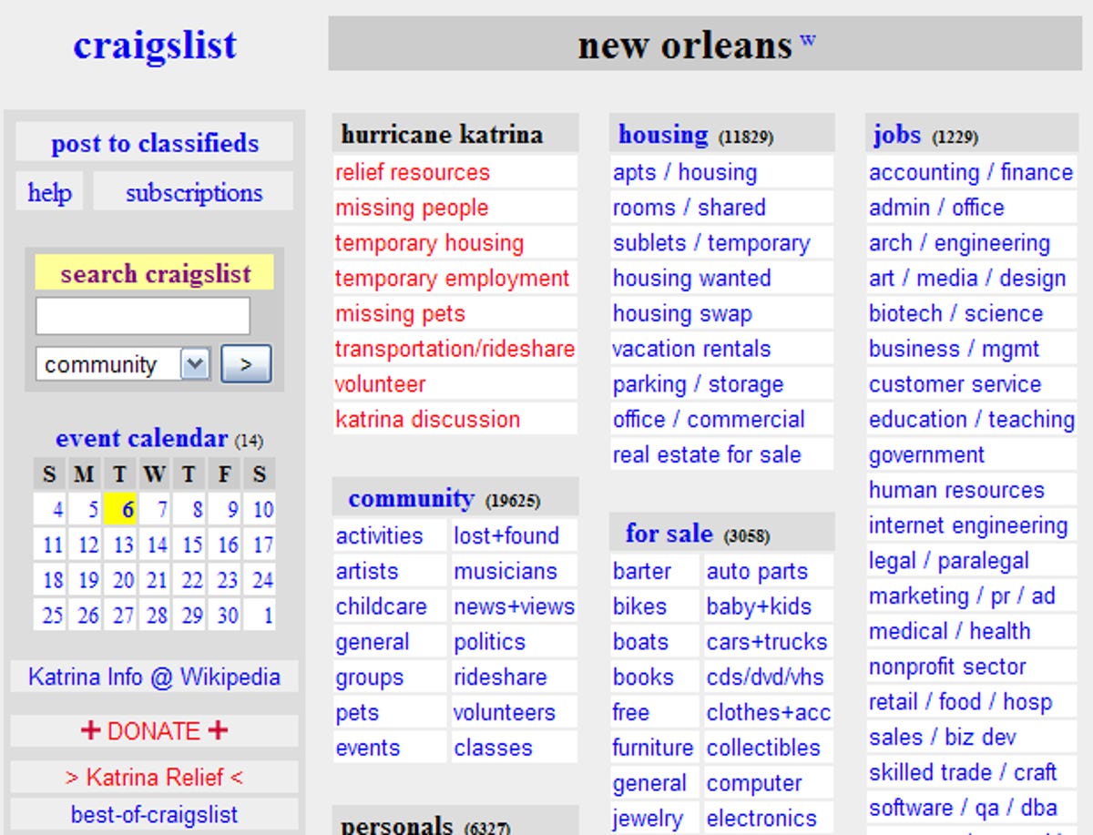
Hurricane Katrina (2005)
Katrina, one of the deadliest U.S. hurricanes ever recorded swept through the southeastern U.S. in 2005, hitting New Orleans the hardest. While Twitter was not yet around, one of the biggest sources of relief (and news) was Craigslist.
Shortly after the storm hit, Craigslist sanctioned off a portion of its site specifically for Katrina-related goings on. The user-powered site was a place for people to post missing persons reports, find relief that FEMA was unable to offer, and share stories that might have otherwise been overlooked by local and national news outlets. In turn, people from local areas swarmed the site, offering what they could to those who were displaced.
This is the New Orleans local Craigslist page, as seen just a few days after Katrina. The site has since put up a resource page.
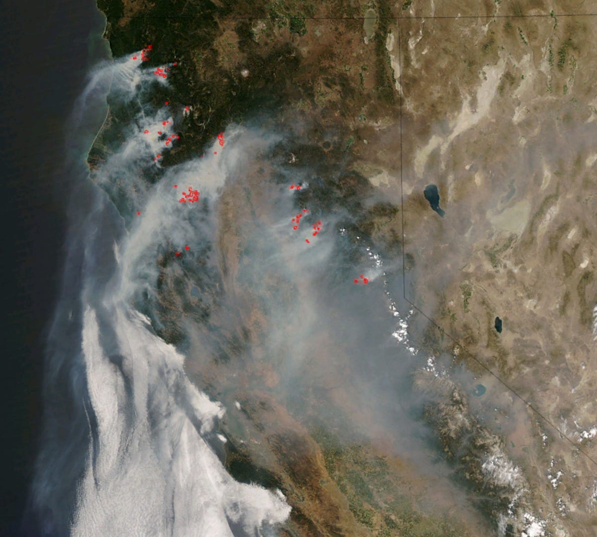
Southern California forest fires (2007)
In late 2007, several wildfires burned through almost 800 square miles of Southern California. One of the fastest updating news sources was Twitter. Both the Los Angeles Times and KPBS News set up special accounts with news updates around the clock. Calfires, a site dedicated to tracking news around the blaze, also set up a special Google map chronicling road closures and evacuation centers.
As the fires continued to spread across the state, one of the most startling displays of damage was satellite imagery, which NASA made available in short order. This data was later added to Google Maps, and can be viewed in a special layer in Google Earth.
This satellite imagery shows the California wildfires raging out of control and spewing smoke hundreds of miles out into the Pacific Ocean.
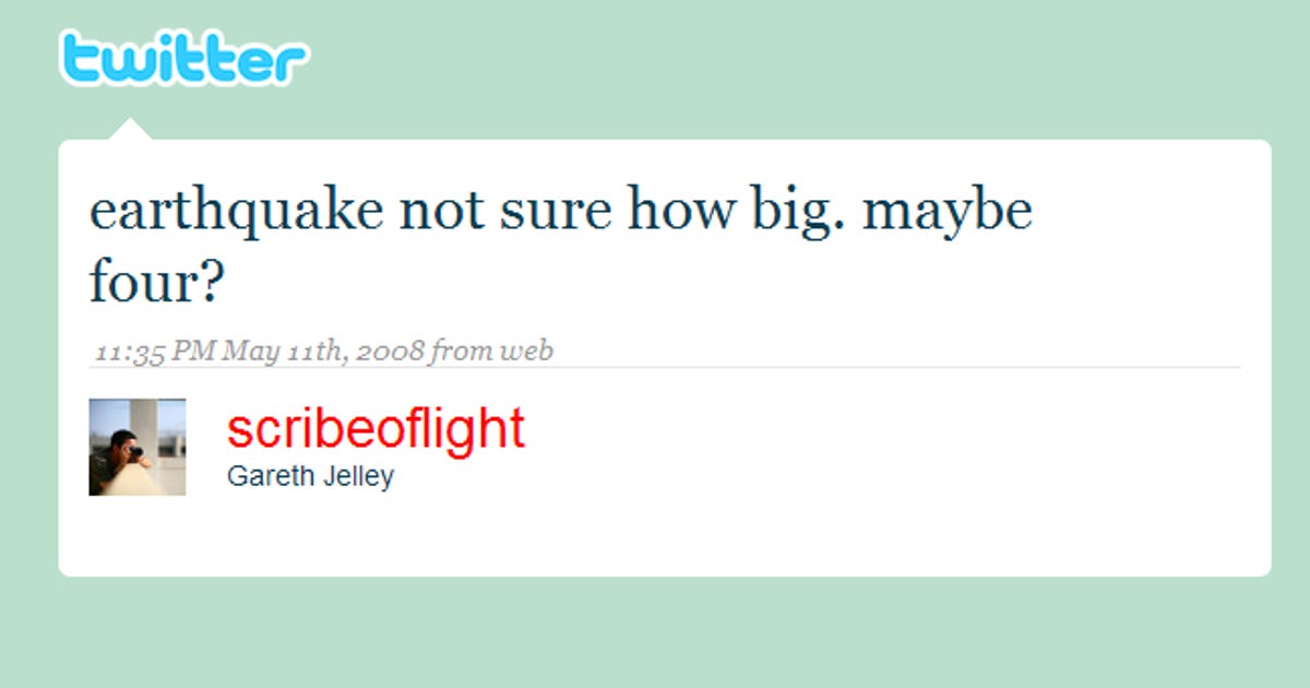
China Earthquake (2008)
A 7.9 magnitude quake shook central China in May 2008, killing close to 70,000 people. One of the most immediate sources for news and photos was Twitter. A stream of Twitter messages helped identify the precise time and epicenter of the quake, a good deal before it showed up on the United States Geological Survey site or any traditional news sources.
Also, like with the Southern California forest fires in 2007, Twitter's infrastructure allowed for a free exchange of information. For instance, people could follow local users who were updating their Twitter feeds with any additional news.
This was the first recorded Twitter message of the quake.
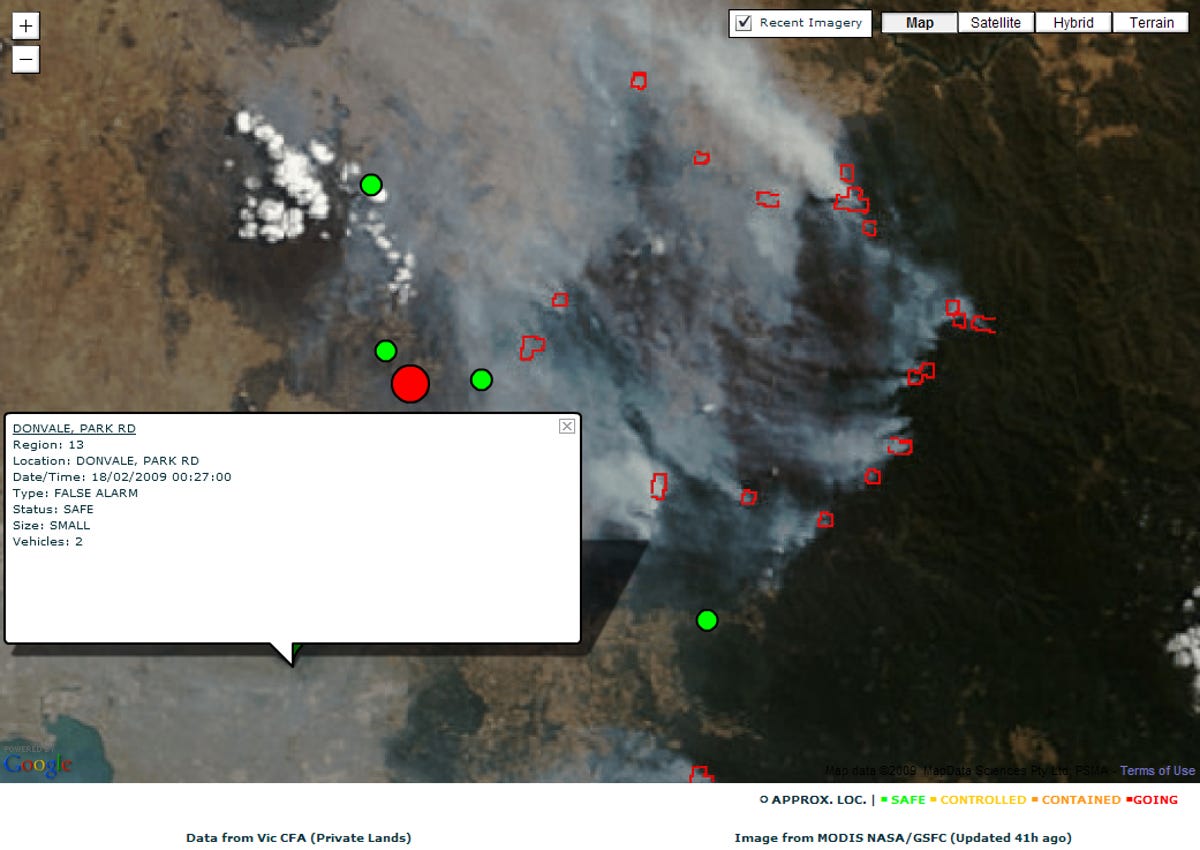
Australian forest fires (2009)
The massive forest fire that continues to ravage Australia's mainland became a struggle for the freedom of information. While geographical data about the fires was readily available from the Country Fire Authority, when Google tried to get information on fires that were on public lands the company hit a dead end.
Victoria's Department of Sustainability and Environment would not share its data, which was deemed private due to the Crown copyright provisions, a set of rules that limits government information from being shared with the public or private companies. Google Australia instead went with satellite imagery from NASA for use on its special maps layer that's tracking the spread and control of fires.
This satellite imagery of the quake was provided by NASA when the Australian government would not provide geodata on where the fires were.
More Galleries

My Favorite Shots From the Galaxy S24 Ultra's Camera
20 Photos
Honor's Magic V2 Foldable Is Lighter Than Samsung's Galaxy S24 Ultra
10 Photos
The Samsung Galaxy S24 and S24 Plus Looks Sweet in Aluminum
23 Photos
Samsung's Galaxy S24 Ultra Now Has a Titanium Design
23 Photos
I Took 600+ Photos With the iPhone 15 Pro and Pro Max. Look at My Favorites
34 Photos
