Reflected light maps Earth's vegetation
Using data collected by the VIIRS sensor aboard the Suomi NPP satellite, NOAA has created a map of the world's vegetation.


James Martin Managing Editor, Photography
James Martin is the Managing Editor of Photography at CNET.
His photos capture technology's impact on society - from the widening wealth gap in San Francisco, to the European refugee crisis and Rwanda's efforts to improve health care.
From the technology pioneers of Google and Facebook, photographing Apple's Steve Jobs and Tim Cook, Facebook's Mark Zuckerberg and Google's Sundar Pichai, to the most groundbreaking launches at Apple and NASA, his is a dream job for any documentary photography and journalist with a love for technology.
Exhibited widely, syndicated and reprinted thousands of times over the years, James follows the people and places behind the technology changing our world, bringing their stories and ideas to life.
Expertise photojournalism, portrait photography, behind-the-scenes Credentials
- 2021 Graphis Photography Awards, Gold Award, Journalism, 'The Doorway' Graphis Photography Awards, Silver Award, Portrait, 'Cast of film '1917'' Graphis Photography Awards, Silver Award, Environmental, 'Upper Lola Montez' ND Awards, Architecture, 'Taj Mah
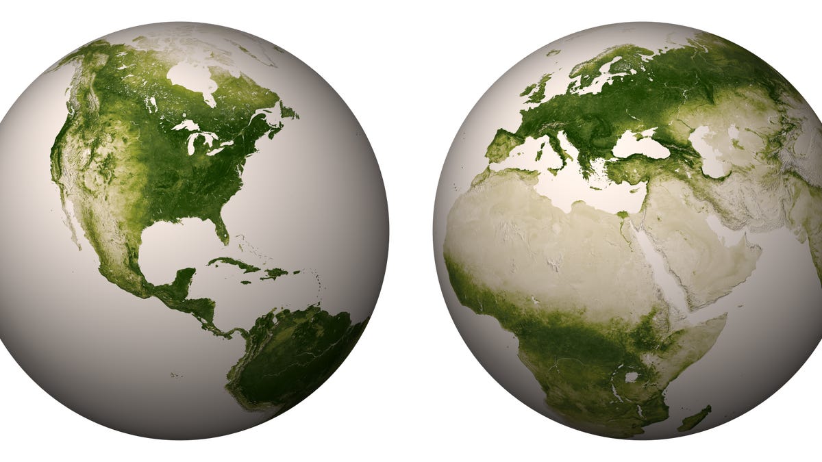
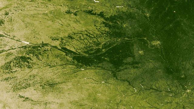
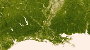
New satellite imagery from the NASA/NOAA Suomi NPP satellite shows the lush green vegetation covering our planet -- along with the changes in geography and climate as the landscape transitions into sparse growth and rock; or hot, dry, barren deserts.
The Visible and Infrared Imaging and Radiometer Suite (VIIRS) sensor, which is sensitive to different types of visible and near-infrared light, collected data from April 2012 through April 2013, allowing NOAA to create what it's calling a "vegetation index" identifying how much of the sun's energy is absorbed by plant life on Earth and how much is reflected back into space.
Plants absorb visible light to undergo photosynthesis, so when vegetation is lush, nearly all of the visible light is absorbed by the photosynthetic leaves, and much more near-infrared light is reflected back into space. However, for deserts and regions with sparse vegetation, the amount of both reflected visible and near-infrared light is relatively high.
Using this data and better understanding the changes in vegetation has many applications. From weather and ecological forecasting to land use policy, a detailed pixel-by-pixel analysis of changes in vegetation from week to week can have some surprising uses. NOAA says data like this can give early warnings of droughts, dangerous fire conditions, and even malaria outbreaks.
You can see the entire world's vegetation mapped here. And check out our slideshow below: