New Google Maps kicks iPhone vs Android battle up a notch
Google's three new big features aren't enough to rocket Google ahead in mapping. But they do keep Google in the game.


Google is aiming to blunt Apple's upcoming abandonment of Google Maps. As Apple moves away from using Google as the built-in mapping product for iOS, Google is trying to keep control of the mobile mapping market in the way we like to see: By innovating on the product. New features from the Google mapping team will make its maps more fun and more useful.
Will they make Google Maps more fun and useful than Apple's maps? That's the big question.
3D: Table stakes
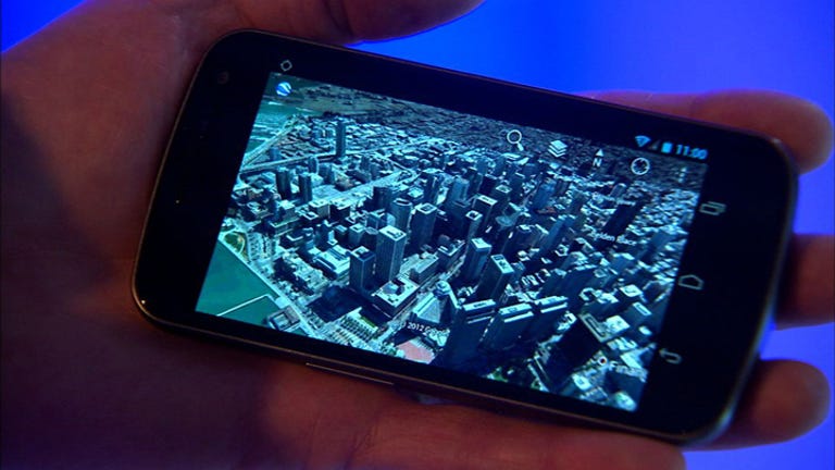
Both Google and Apple now have technology to create 3D maps that include buildings. Neither has rolled the product out yet. Today at Google's San Francisco office, we saw Google demonstrate its new 3D mapping product that will use its own library of aerial imagery to build fully-modeled 3D cities.
The ability to fly through a city and see all its buildings and trees as if you were "flying in your own private helicopter" is incredibly cool. In the demo we saw, most buildings looked close to photorealistic, although some (in particular the AT&T ballpark), had strange artifacts showing.
This 3D feature would be a great spiff for Android users and a great reason for iPhone users to download a new Google Maps app for that platform. Except for one thing: Very soon, this won't be a unique feature. Apple bought C3 Technologies in October, and that company does exactly what the new 3D feature in Google Maps does: It turns aerial photos into 3D models.
So the game will be coverage and usability. Apple's got the leg up in designing beautiful interfaces, but Google certainly has more experience in geo interfaces, both grown in-house (Google Maps) and from acquisitions, like Keyhole, the foundation of Google Earth, acquired in 2004.
So 3D isn't going to be a slam-dunk differentiator. What about Google's mobile feature that lets users download a city map for offline use?
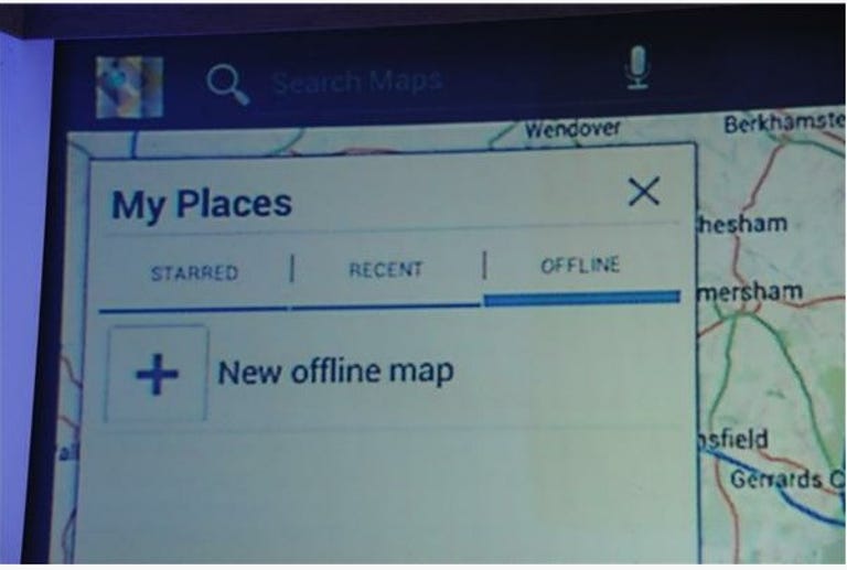
This is a good and very useful feature. It's the kind of thing geeky people tend to ask for and will use, but it's not one of those differentiators that masses of people will change a smartphone buying decision over. Especially since no carrier will dare advertise it. Picture the ad campaign: "Try offline maps on our Galaxy phones, which work even when our network doesn't!"
This would be a great feature for Apple, though. The hardware company isn't beholden to carriers. And an offline map library would fit well in the iCloud pitch. Will Apple ape this feature? Will it matter?
Street View expansion: Ok, that's fun
What ultimately does matter in mobile mapping is coverage. Google has a very large head start in data: It started by gathering and buying publicly-availalbe maps and satellite imagery, then layered in aerial photos, then went out and made its own library of Street View images. Now it's going to replace its aerial city images, via contracted and "its own" airplanes, I was told (no drones yet). It is also taking its mapping mission indoors and to the great outdoors.
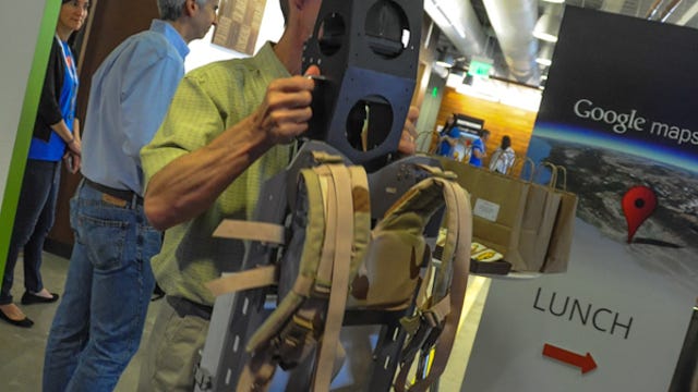


Google talked about its new Street View trolley cart system for getting photos from inside buildings, like art galleries and airports. It also unveiled its backpack Street View camera system for capturing images from hiking trails, ski slopes, and other areas accessible only on foot. These new Street View vehicles join the Google fleet of cars, tricycles, and snowmobiles around the world.
Apple is unlikely to launch with the same depth of indoor and off-piste data as Google, and it probably won't matter much. The main battleground is for city street maps. The rest is for fun. For Google, which makes money from advertising, the indoor mapping will open up a revenue stream, but it isn't going to make much of a dent.
We need to hear more about cars
As I wrote in my wishful-thinking post before Google's latest announcement, the real platform battleground for mapping is not the smartphone. Google will run the maps on Android; Apple will on iPhone. Some users will use third-party apps (like Waze on Android or Google Maps on iOS). But cars are a green field and the most important platform for nav apps.
For cars, and the necessary feature of traffic reporting, the more users you have running your geolocation software, the more data you have about how fast people are moving. Apple's adoption of its own mapping platform means it will now get access to that data from its iPhone users, assuming (and it's a big assumption) that Apple can hurdle the privacy issues over gathering that data.
Once, or if, Apple and Google are at parity in gathering traffic data, then the battle for the car can begin. Apple will be far behind Google here, though, thanks to its we-must-control-everything attitude on how its products are displayed. Car guys don't like that so much. But with Android, developers can do what they want.
Back to smartphones, which is what matters right now: Apple's defection is the best thing to happen to Google Maps. It's forcing Google to up its game. The Google team has, so far, been doing a good job keeping the innovations coming and keeping its maps database growing. But now with Apple gunning for it, it's going to have to do even better.
What can Apple do with its maps to leapfrog Google? Stay tuned. All should be revealed next week at WWDC.