How to use satellite data to track Las Conchas fire
Tired of waiting for officials to update you on where the wildfire is active? Satellite data in Google Earth can give you a fast, rough look.


- Shankland covered the tech industry for more than 25 years and was a science writer for five years before that. He has deep expertise in microprocessors, digital photography, computer hardware and software, internet standards, web technology, and more.
The Las Conchas wildfire, a 92,735-acre blaze extending around the community and national laboratory of Los Alamos, N.M., often moves faster than the officials who monitor it. That can be frustrating for people who want to see where the fire is burning.
But NASA has an automated answer for the impatient: the MODIS satellite. It records fire data, and the U.S. Forest Service packages it up so Google Earth users can get a rough but useful view of the fire's behavior.
Here's how to take a look. But first, I'll share a sobering NASA photo taken from the International Space Station on Monday, the second day of the fire.
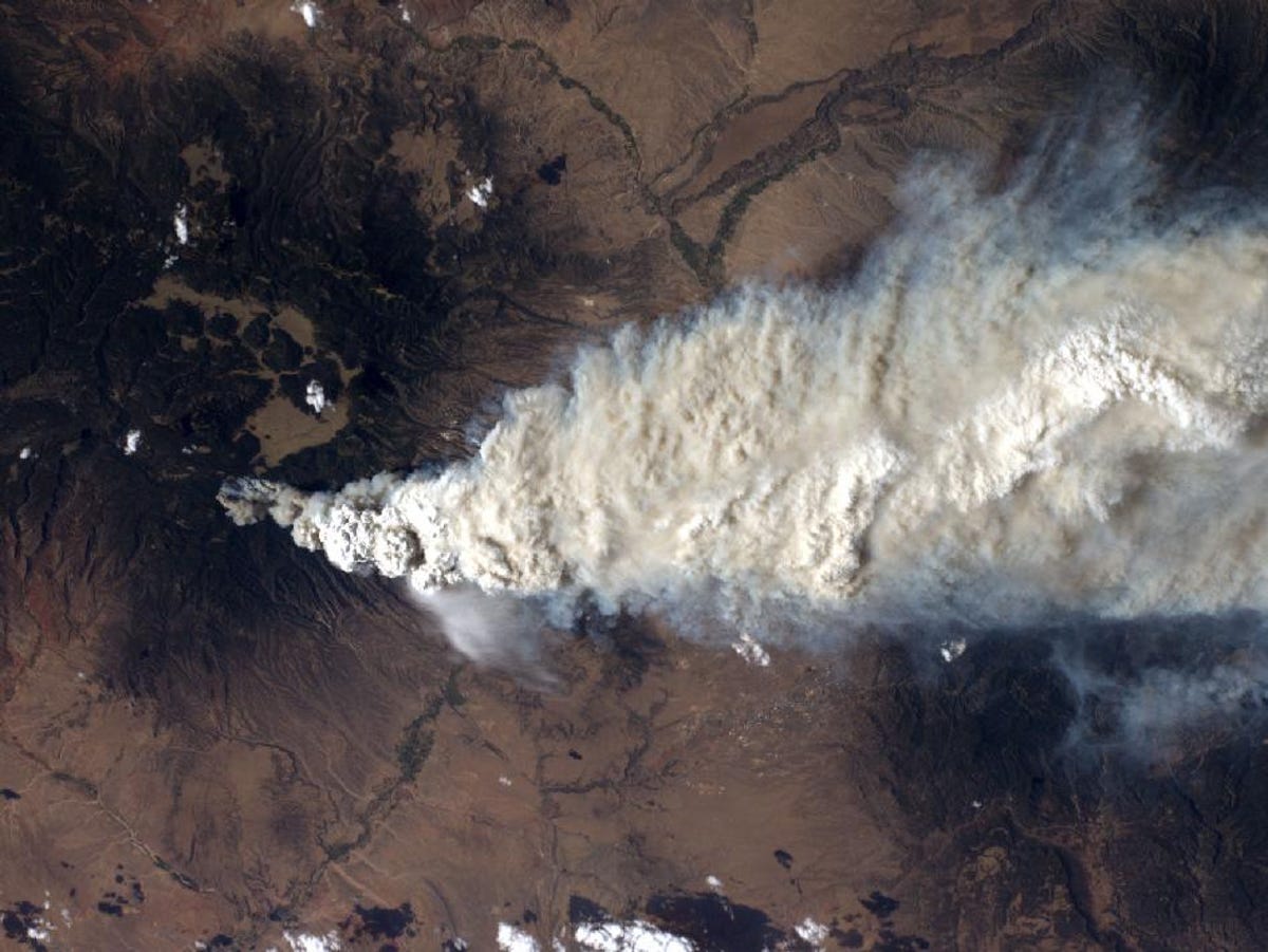
It's a daunting image for anyone like me who knows the area and the scale involved. There are 752 people fighting the fire right now, including four bulldozers, 28 fire engines, and five helicopters. Since the Cerro Grande fire of 2000, which burned hundreds of Los Alamos homes and thousands of acres of Los Alamos National Laboratory property, the lab has taken new fire counter measures including more forest clearing and automatic fire-suppression systems. So far today, physical risks to the lab are lower than earlier in the week, LANL Director Charlie McMillan said.
OK, so here's how to get the live fire data. First, you'll have to install Google Earth. If you're not familiar with this software, it's basically an interface to look at the planet through satellite photography. It's got lots of overlays, some such as 3D buildings and geographic place names from Google, and countless others added by third parties that have a desire to show geographic information.
One of these third parties is the fire data. It's stored in a file format called KMZ, which is a compressed version of the KML technology. (Historical aside: KML began its life as Keyhole Markup Language, and Keyhole was the company that developed Google Earth before Google acquired it and turned KML into an industry standard.)
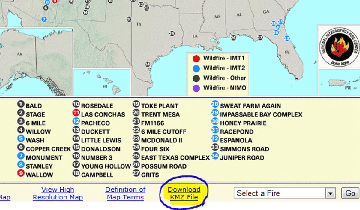
Anyway, next go to the Forest Service's Active Fire Mapping Program Web site.
Down toward the bottom, underneath the map, click on the "Download KMZ File" link and save the file in a place you'll remember. I give it a filename that records the date and time--"MODIS fire 2011-06-30 1442MDT.kmz"--because later you might want to compare snapshots from different times.
Next, switch over to Google Earth and select File, then Open. Open up your KMZ file. You should see a red rectangle appear around the United States and a bunch of yellow, orange, and red dots scattered where there are fires.

Of course, you have to zoom in to the area of interest yourself with the zoom slider to the upper right of the map view or by using a mouse scroll wheel. It's faster, though to type "Los Alamos, NM" into the search box in the the upper left corner of Google Earth. Typing the "87544" ZIP code will get you a broader view of the whole county.
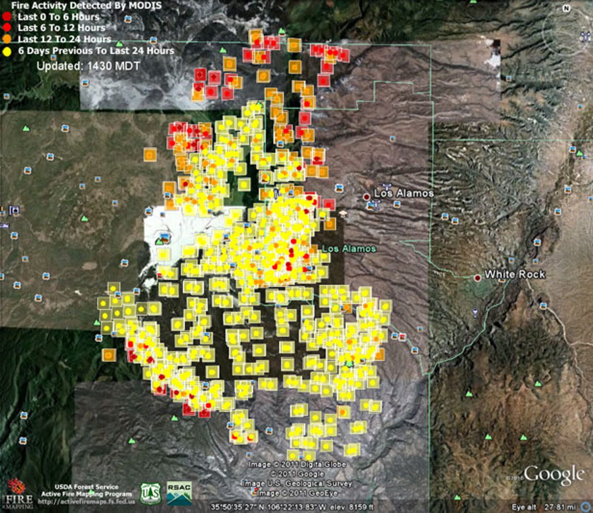
When you get close, you'll see yellow, orange, and red squares. You might think the color coding corresponds to fire intensity, but that's only indirectly the case.
In fact, the colors correspond with how recently the satellite recorded fire in a particular area. Red means within the last six hours, it gets older from that until yellow, which is more than 24 hours.
If you download a new file later, you'll get a lot of visual clutter, because the old information is underneath. To hide the older layers, uncheck them in the "temporary places" folder underneath the "Places" section on the left of Google Earth.
You might also want to save the files. When you quit Google Earth, the software will ask you if you want to save your file to your "My Places" folder. You can, but you can also let the software forget it; you can open it again if you want to as long as you don't delete the original KMZ file you downloaded.
Below is a view I just created. You can of course use this to view any other fire data in the country, too.