How Navy supercomputers help sailors beat an ancient nemesis
At the Fleet Numerical Meteorology & Oceanography Center in Monterey, Calif., the U.S. Navy produces some of the world's best maritime weather forecasts. CNET Road Trip 2012 investigated.


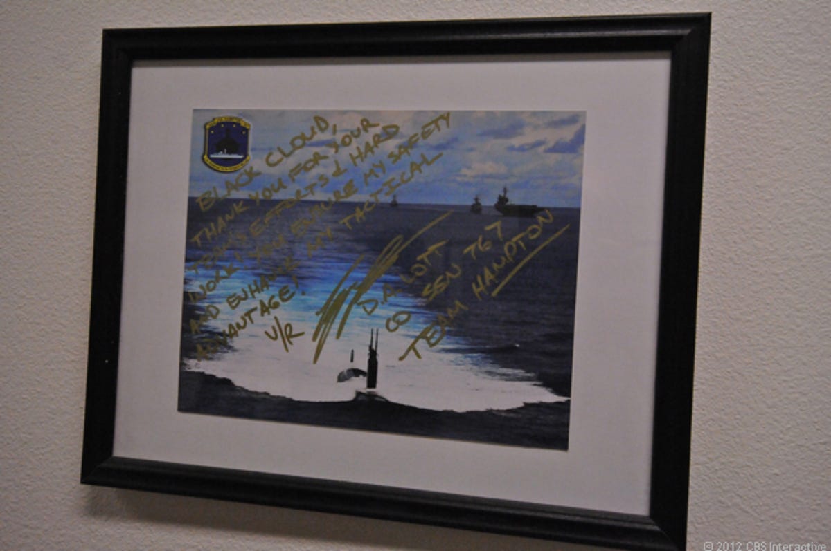
MONTEREY, Calif.--One after another, the framed pictures on both walls of the narrow hallway tell the story: submarines and naval ships churning white wakes as they slash through open ocean, each photo accompanied by unbidden gratitude.
"Thank you for your team's efforts & hard work! You ensure my safety and enhance my tactical advantage," one reads.
Welcome to the U.S. Navy's Fleet Numerical Meteorology & Oceanography Center. That long-and-hard-to-say name notwithstanding, this is one of the United States military's sharpest weapons in the never-ending battle for survival in rough seas all around the globe.
A supercomputer center hidden behind guarded gates in an unassuming residential neighborhood in this coastal California city about two hours south of San Francisco, Fleet Numerical, as it's known, counts among its many tasks giving sailors the world's most up-to-date and reliable weather forecasts, information they can use to try to withstand the mariner's ancient nemesis -- unpredictable weather -- while also attempting to stay one step ahead of any potential human foes.
At its core, Fleet Numerical's mission is simple: it must use its collection of supercomputers -- Top Secret, classified and unclassified -- to provide the best possible weather forecasting to both Navy fleet weather centers in Norfolk, Va., and San Diego, and to Navy aviation assets around the world. And, since 2008, the facility has been responsible for sending the Navy's submarine fleet weather data that can help them decide when to surface, or more importantly, when not to. That mission was added after a Naval tragedy in which a number of submariners died at sea when their ship encountered a storm of unexpected ferocity.
There are other weather centers, of course, but as commanding officer, Capt. Erika Sauer (see video below), told me when I visited Fleet Numerical yesterday as part of Road Trip 2012, the facility benefits from its immediate proximity to weather and supercomputing experts at the Naval Research Laboratory, the National Weather Service, and the Naval Postgraduate School, all of which are in Monterey. That allows Fleet Numerical's team of just 13 officers, 13 enlisted, and 128 civilians to do a job that the National Weather Service's own forecasting center needs at least three times the resources to do, while the U.S. Air Force's needs twice as much, Sauer explained.
NOGAPS
Fleet Numerical got its start as the Navy Numerical Weather Problems Group in 1958 in Suitland, Md. A year later, it relocated to Monterey, and in 1961, it was renamed the Fleet Numerical Weather Facility. Last year, the facility celebrated its 50th anniversary.
Today, its major product is what is known as NOGAPS, or the Navy Operational Global Atmospheric Prediction System. This provides forecasting at a resolution of about 21 nautical miles and 42 vertical levels up to 106,000 feet. But Fleet Numerical has other products it provides its "customers" in the Navy, the Department of Defense, and among coalition partners, including the Coupled Ocean/Atmospheric Mesoscale Prediction System, which is a "regional mesoscale model, multi-nested to (about) 1,800 yards to 14 (nautical miles) resolution (and) 45 vertical levels.
As well, there's the WaveWatch III, a spectral ocean wave model with global (21 nautical mile) and regional (3 nautical mile) implementations; the Ensemble Forecast System, a 20-simulation, 15-day forecast; and the Navy Atmospheric Aerosol Prediction System, "the only operational global aerosol model," which is used to feed the military's Target Acquisition Weapons Software.


More from Road Trip 2012: Tech out West
Check out the latest from Daniel's tour of all things geeky in the Golden State, with jaunts into Nevada, Arizona, and Oregon, as well.
Fleet Numerical's most powerful supercomputer is a Dell Linux cluster system known as A2 Emerald with 27.3 peak teraflops. But that runs the center's unclassified global modeling, which brings in giant amounts of data from countries all around the world. Its classified and Top Secret computers are smaller, and are geared towards much finer resolution regional and local modeling.
And while even A2 Emerald can't hold a candle to the world's most powerful supercomputers, it is nevertheless a system that has gotten better over time. In 1988, it took as much processing power to produce a 72-hour forecast as it now takes to generate one of five days.
Overcoming uncertainty and providing an advantage
One of the key missions at Fleet Numerical is to help those who need it get an advantage when having one is essential. That can range from the aftermath of regional disasters like Japan's disastrous 2011 earthquake and tsunami to offering the best assessment of wind probabilities to crews handling the Deepwater Horizon oil spill crisis in 2010. And of course, the U.S. military and its friends can imagine many ways that knowing more about weather conditions at sea than its enemies could be a big advantage. "By using this system and technique," Sauer said, "it allows you to quantify uncertainty."
This involves an intelligence mission, known as the Information Dominance Corps. One example of that, she explained, is how the Navy is utilizing Fleet Numerical's data in combating piracy off the coast of Somalia. There, pirates are known to stick to calm waters, and with the data in had, the U.S. military can pre-position itself in areas deemed likely to meet the pirates' needs.
In the end, Fleet Numerical is 24/7/365 facility geared toward ensuring that the Navy has the best-possible weather data for taking on the many challenges it faces around the world every day, weather that's on the surface of the sea, or well above it. And that's why that wall inside the center is adorned with so many paeans from commanders who know that the work done here helped them do their jobs better. That's why sailors like the commander of the submarine, USS Texas, wrote on one of those photographs, "You directly supported our last mission with timely and vital information. You make a difference to our success. THANK YOU!"