GPS: not just for the car anymore
Declining prices and improved miniaturisation mean GPS is making its way out of the car and into other gadgets. You may never get lost again.
If you've bought a new car in the last few years, you may already have a built-in navigator, which uses GPS (global positioning system) technology and a lilting voice to guide you to your destination turn by turn. These days, however, lowering prices and improved miniaturisation mean GPS is making its way out of the car and into other gadgets. You may never get lost again.
Once considered a luxury for bush trekkers and the military, steadily declining prices for GPS technology and improved mapping services have pushed in-car mapping devices from Mio, Garmin, TomTom, Navman and others into the realm of affordability.
Not ones to be outdone, makers of PDAs and mobile phones are getting into the game with jack-of-all-trades devices that integrate GPS alongside their core functions. Smartphones like the HP hw6965 Mobile Messenger, ASUS MyPal A639/A686/A696, Dopod P800W, and GigaByte G-Smart i300 offer all the accoutrements of your normal pocket email devices, but can double as road navigators and feed GPS data to Windows Mobile applications. Nokia has promoted GPS as a core feature of its N95 do-everything device and its less expensive 6110 Navigator, while Research In Motion's BlackBerry 8800 also integrates GPS.
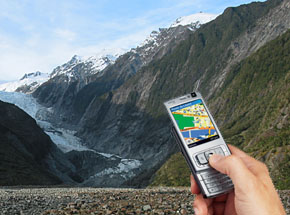
Your GPS enabled phone could lead you to the base of Franz Josef glacier, New Zealand
(Photo Credit: Derek Fung and Nokia)
Julianne Bean, iPAQ market development manager with HP, says nearly 30 percent of HP's Australian iPAQ sales are now GPS-enabled, reflecting a growing trend that's expected to put more than 600,000 GPS units into the hands of Australian consumers this year alone.
"The market is very diverse and we've seen a very strong consumer takeup of the technology," she says. "People are looking at GPS solutions they can regularly update and have in the car or out of it. We're also seeing courier companies, manufacturing and other companies using GPS as devices to be able to make their staff more productive."
Decisions about which devices to GPS-enable are still being made based on form factor. For example, Sony sells GPS receivers not for its normal notebooks, but offers an add-on for its VAIO UX series of ultra portable mobile computers, the diminutive notebook-cum-PDA devices that fit into two hands.
If your existing device or favoured purchase doesn't have GPS built in, a number of options can fix that. For example, the Haicom XDA II Mini / i-mate JAM Pro GPS Kit bundles a GPS receiver, device mount and Bluetooth connector to GPS-enable those particular smartphones, and similar kit is available for other types of phones. Nokia's Wireless GPS Module LD-3W takes a similar approach, using Bluetooth to GPS-enable both Nokia and non-Nokia phones, PDAs and PCs.
Finding yourself
All this means that whether or not you bought your device with GPS in mind, you can still add that geographic element to any type of applications you happen to be running. Just what those applications are, however, is still gradually becoming clear.
Unsurprisingly, navigation software for Windows Mobile devices -- paired with one of a number of map databases covering different parts of Australia -- is typically the first GPS enabled application you'll use. However, these PDAs add around $600 to the price of a standalone GPS navigator, so you'll probably be more inclined to spend the extra only if you want GPS capabilities outside your car.
Choose your mapping software provider carefully: anecdotal reports suggest that while most providers are pretty accurate within major metropolitan areas, once you get into rural areas the accuracy and currency of the maps varies widely. Some reports suggest Destinator is particularly good, while others have favoured CoPilot or TomTom. Accuracy often comes back to the combination of specific GPS chipset and the currency of the data (most Australian products use the same maps from Sensis as their base data).
The real value of getting a non-car GPS system, however, lies in the ability to use your location information for other purposes. The most obvious is to feed location information into online applications, like the Google Maps Web site, which can overlay GPS information on top of satellite images to show you a detailed view of your surroundings. Combined with live Internet connections, similar services might be used to locate nearby restaurants or guide walking tours of national parks, using live information feeds to pull down background information on the sights near you.
CNET.com.au's downloads section lists over 200 GPS-related applications for you to peruse. For example, GPS 2 Google records GPS data over time, then stores it as a KML file viewable within Google Earth so you can relive your bike trip or holiday using that application's detailed maps. GPS To Excel records raw GPS data into an Excel spreadsheet for whatever use you might want, while SpeedTracker lets you track the speed of your jogs or bike rides and WeGolf plots the path of your golf ball through a round.
Although it's UK and US only for now, Traffic Vizzion is another great example of how GPS becomes a useful data feed when paired with a general purpose computing platform: by tracking your location and comparing it with locations of live traffic cameras, that application can look ahead so you can literally see how congested the roads ahead of you are.
Smile and say 'here!'
Finding yourself on a map isn't the only use for embedded GPS technology, however. Although it's a bit uncool for older kids and showed so-so performance in our tests, the mobiles2go i-Kids phone highlights the value of combining a basic mobile phone and GPS. Using the i-Kids, parents can plot their child's position on the Web, and can set 'safety zones' that are continually monitored by the phone. If the child leaves the zone, the parents are automatically alerted via SMS.
Just how long it takes before kids learn to leave the i-Kids at school when nicking over to a friend's house for a long lunch is up for debate, but the point is that GPS is being harnessed in novel ways to allow geographically based services that were just never possible before.
Another increasingly popular activity is 'geotagging' -- the act of inserting geographical information into other content, specifically photographs. Since every photograph was taken somewhere, adding this information makes great sense -- and new products make it easier than ever to add this information to pictures.
This sort of combination has been available for years in scientific circles, but at very high cost and complexity. Today's market, however, now includes devices such as Sony's GPS-CS1, a keychain-suspended tube that contains a GPS receiver charged with taking location readings every 15 seconds.
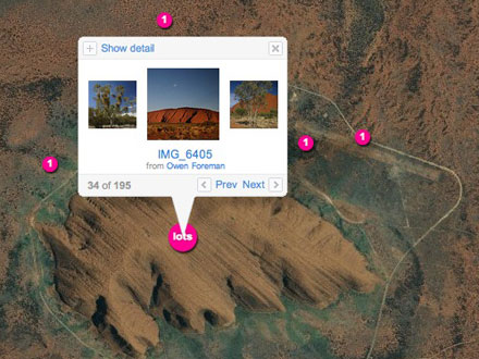
Geotagged photos on Flickr of Uluru, Australia. Credit: Yahoo
Take it with you while on a photo shoot or holiday, and at the end of the day the Sony-only bundled software scans the time each photo was taken and matches it with the latest recorded location at that time. Cameras such as the Ricoh 500SE build GPS inside the body, while Navman's N60i in-car navigator bolts on a digital camera to its core GPS circuits to take a different means to the same end.
Once you've recorded location information inside your pictures, the fun starts. Contemporary photo tools like Google's Picasa and the Flickr photo sharing site support geocoding, with pictures tied to Google Earth and Flickr's Yahoo! based maps to facilitate sharing. When other users browse an area, pictures geocoded in that area are automatically shown.
A search on Flickr shows more than 836,000 geotagged photos on Flickr, and this number will likely grow as cameras with integrated GPS become more widespread. In the long term, tying images with physical locations will help fill out our view of the world we live in, and the people in it. It's only one of the many uses for GPS, but is proof positive that much can be achieved if you only know where you are.