Facebook's plan to connect the world with lasers and drones is more than pie in the sky
With test flights scheduled for later this year, Facebook's project Aquila is nearly ready for takeoff.


How do you solve a problem like connecting the 1.7 billion people to the Internet who live outside of the range of mobile broadband?
If you're Facebook, the answer is drones. Also, lasers.
Facebook's drone project, named Aquila, is one of several initiatives the company is testing as part of the Internet.org coalition to try to improve global Internet access. In spite of its outlandish nature, it is one of the less controversial projects that Internet.org is working on, unlike its Free Basics package, which found Facebook embroiled in a worldwide debate over open and equal Internet access.
The company's chief executive, Mark Zuckerberg, during his Mobile World Congress keynote on Tuesday touched on the already public plans to extend Internet access to unconnected areas of the world using solar-powered planes. During a briefing here in Barcelona, the company's vice president of engineering, Jay Parikh, and Connectivity Lab leader Yael Maguire went into more detail on exactly what Facebook is up to with creating the drones and the lasers they'll carry.
If it succeeds, Facebook's aviation project would break new ground for drones. The US military for years has used sizable unmanned aircraft such as the Predator and the Global Hawk for reconnaissance, surveillance and other intelligence-gathering activities in battle zones. On the civilian side, drones -- typically small enough to be held in one or two hands -- are a more recent phenomenon that's just starting to break out of its niche of toy and hobbyist uses and into commercial applications.
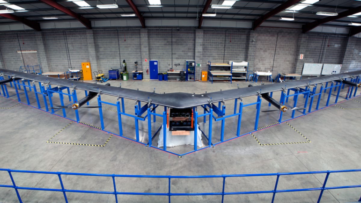
Facebook's first full-scale aircraft at the moment is tucked away in a secret location somewhere in the US ahead of being flown for the first time later this year, Parikh said. Plans are being finalized for the takeoff and landing, as tweaks are being made to the software and aerodynamics.
When the plane does fly, it will be high above commercial aircraft at between 60,000 and 90,000 feet (18.4 and 27.5 km). One challenge at that altitude: The atmosphere is extremely cold, so the on-board equipment will have to be able to withstand low temperatures. Built from carbon fiber to keep it light but strong, the drone measures 138 feet (42 meters) wing tip to wing tip and weighs about 1,100 pounds (500 kg). Each plane will connect to a terminal on the ground, where the wireless capacity will be redistributed to the community through LTE or Wi-Fi.
The grand vision for the drones is to get them to form a network -- "a backbone in the sky," as Maguire called it -- bridging communities and connecting them to the urban center. This is where the lasers come in. They'll sit on top of the drones, allowing them to communicate vehicle to vehicle. Millimeter wave technology would be used to send the Internet signals to the ground.
Because the drones will fly above weather systems in the atmosphere, the lasers have an extremely clean environment to operate in, with nothing to throw them off course. Laser performance, said Maguire, is "an intense area of focus for us."
They've also built a prototype of the laser terminal that will eventually reside on the plane. Made out of the same carbon fiber material as the drones themselves, it weighs just 7.7 pounds (3.5kg).
Mapping the unconnected
Where to place the drones? Facebook had to pinpoint where exactly the unconnected people in the world live -- no easy task.
The only available data came from a world census run by Columbia University. But when the team zoomed in to look at individual settlements, the resolution was nowhere near high enough to work out where the drones will need to fly.
Members of Facebook's Connectivity Lab put their heads together with the company's machine learning team and analyzed publicly available satellite data around the world, using image recognition to identify signs of life.
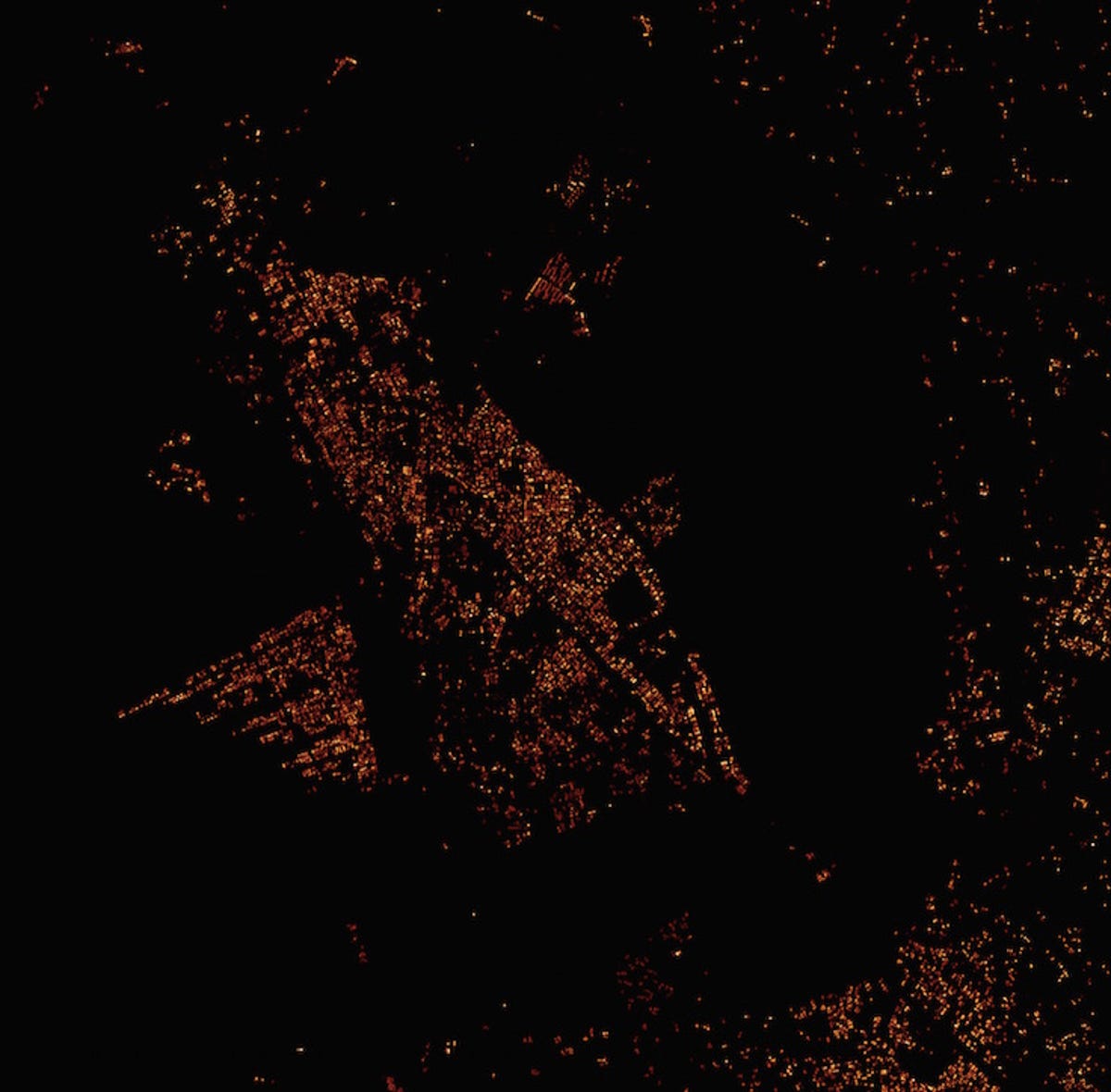

Facebook has created high-resolution maps of population distribution in unconnected areas. This one shows the town of Naivasha, Kenya.
After processing 14.6 billion images from 20 countries and generating 350 terabytes of data, Facebook came up with the off-the-grid figure of 1.7 billion people. The Connectivity Lab plans to make all of this data open to the public later this year.
There are still major challenges ahead. The current record for keeping a solar-powered plane in the sky is two weeks, and Facebook wants its drones to be capable of flying for at least three months at a time. "If we can pull this off, it will be a significant breakthrough for an autonomous, low-power high-altitude plane," said Maguire.
Accuracy of the lasers is also a challenge. If you've ever used a laser pointer, you'll know how tricky it can be to hold the beam perfectly still. The same will be true for Facebook's lasers, except they'll be firing them over very long distances between moving unmanned vehicles. "The team thinks they have the technology to make that work," said Maguire, "and we're now testing it in the lab."