Massive Petra monument 'hiding in plain sight'
The World Heritage Site at Petra, Jordan still has a few secrets -- one of which has just been discovered thanks to aerial technology.


A monumental structure has been discovered at the World Heritage Site of Petra, the ancient city carved into the cliffs of Jordan in the Middle East.
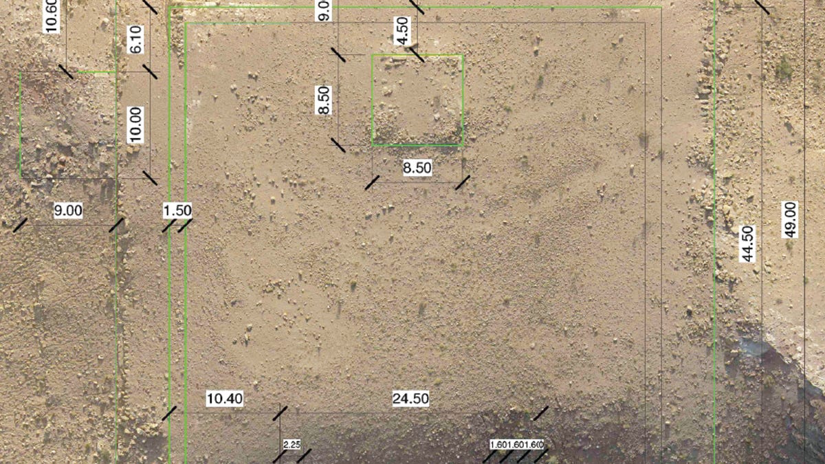
The previously unknown structure was discovered thanks to satellite imagery from Google Earth, satellites WorldView-1 and WorldView-2, and drones sent to photograph the site. It's located about 800 metres south of Petra's centre, According to a study published in the Bulletin of The American Schools of Oriental Research,
The structure is large, about as long as an Olympic pool and twice as wide. It consists of a platform measuring 56 by 49 metres (184 by 161 feet), with a smaller platform on top, measuring 8.5 by 8.5 metres (28 by 28 feet). This second platform was originally paved with flagstones, and its east side had once been lined with a row of columns topping a giant staircase, National Geographic reports.
It's unlike anything else at the site.
According to the archaeologists who wrote the paper, National Geographic fellow Sarah Parcak and executive director of the Council of American Overseas Research Centers Christopher Tuttle, it probably had a ceremonial function, and was built very early. Petra dates back to the fourth century BC, and pottery on the structure dates back to the middle of the second century BC.
Further research on the site is pending, but the discovery is evidence of the strength of high-resolution satellite imagery as a tool for revealing sites of archaeological interest, and of drones for scouting.
"Given the discoveries at Petra, WV-1 and WV-2 satellite imagery analysis has much to offer other archaeological projects, especially at well-known sites with similar environmental conditions, where new (and surprising) discoveries continue to make headlines," the study concludes.
"Ultimately, satellites allow us to see, think, and visualise past landscapes differently. It appears that they are now a standard archaeological tool, and one that should be used with more frequency, as we take much for granted in terms of what is left to discover, even when monuments are hiding in plain sight."