Crowdsourced cartography in PublicEarth, OpenStreetMap
Can a crowd of amateur mappers create better guidebooks and maps than professionals? Signs point to yes.


Wikipedia killed the encyclopedia business, in print and online, as it's hard to make a revenue model work that involves paying people to create content when there are hordes of enthusiastic experts around the world willing to do the job for free. The business of mapping may be similarly doomed, as indicated by PublicEarth, a new wiki-style database of places launching Monday, and by the continued improvement in authoring tools at the crowdsourced mapping service OpenStreetMap.
PublicEarth
PublicEarth is an open database of places. Michael Rubin, who was an architect of Netflix, wanted to bring the same "element of delight" of connecting people to things they enjoy. Netflix did it for movies, and Public Earth is doing it for locations.
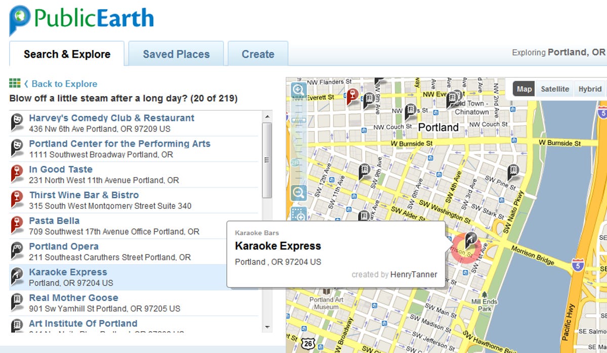
As with other crowdsourced place databases, anyone can insert a location. And as with most of the other products, PublicEarth uses Google base maps. The difference in PublicEarth is in the execution: It's slick, in a good way. For map users, PublicEarth lets you quickly find categories of locations -- romantic, kid-friendly, historic, for campers, etc. -- for places you are going. When you're looking at a map of places, you can get a lot of data by just rolling your mouse over hot spots, without clicking. "We learned how expensive a click is," Rubin says.
The system will have a recommendation engine that learns what you like. So if you've been using the system and then head to a new town you can just see the "recommended for you" locations.
The real value to PublicEarth is that it can find places that aren't, as they say, on the map. It's very easy for users to create a point of interest, draw a boundary line around a park, or trace a route to walk or hike. If enough people get into this system it could be a great resource for travelers. Which is the business model.
The PublicEarth team wants to make this service the go-to database of unusual places, and to partner with standard booking sites like Hotels.com, OpenTable, and travel solutions like TripIt. Getting traffic from those sites will get people into the system, and then sending booking and ticket traffic out to venues will generate revenue.
PublicEarth is also being marketed to activity groups like RV and sports clubs, parents groups, birdwatchers, and so on. It can be used by social networks to collect and collate locations aimed at specific interests, which can help people with those interests when they visit a new region.
Of course, success hinges on contributions, and it's not easy to create a user-maintained location database that sticks. There's also competition: Wikimapia and Yelp come to mind. But if PublicEarth can affiliate with other travel resources it could work out. It is a very strong product. It has the potential to compete with the guidebook market.
OpenStreetMap
PublicEarth is an open database of items on top of a map. OpenStreetMap is a crowdsourced map itself. The project was started before Google Maps came on to the scene, and while the search juggernaut's global road map is certainly more popular, there's a lot to be said for the OpenStreetMap approach. The fact that anyone with an interest in an area can create, correct, or update a map means you can get a lot of very specific data onto the map, created by people with very specific, nearly microscopic, knowledge of their regions.
And since the OpenStreetMap data itself is open, developers can do anything they wish with it. With a commercial map like Google's you have to push everything through one API, but with a truly open system you can create your own maps from the data, perform calculations on map points, and so. OpenStreetMap would be a great mapping database for the calculation engine Wolfram Alpha.

Later this month a new map editor, MapZen, is coming to the system from CloudMade, a company that commercializes the OpenStreetMap project. MapZen will make it easier for mappers to create and correct roads and points of interest. An iPhone app, currently in approval limbo, will also make it easier for anyone to walk and map. And new social tools should be good for to help groups of "map buddies" coordinate their work.
The MapZen/OpenStreetMap combo also lets you do very specific and modern cartography. There's a junction editor, for example, that lets contributors specify turn restrictions by time of day.
CloudMade will monetize the system by offering search features and routing (with awareness of the junction turn restrictions), and possibly by working on location-based advertising.
OpenStreetMap currently matters more to people in less-mapped regions than to dwellers of hyper-mapped U.S. cities. But ultimately the system may enable new location-based apps and services thanks to its wide-open system.
The crowded map
Google has already added a form of crowdsourcing to its mapping services: Its traffic system gets location and speed data from its mobile users. (Users can get their own raw data through Latitude, if they wish.) But Google relies on its own private mapping data, and its own servers to deliver maps to users. It's an expensive model and it doesn't serve all users in all locations equally. The crowdsourced mapping model is a serious competitor to the proprietary map business. I wouldn't have thought it could work, but Wikipedia shows that it's a mistake to dismiss the power of millions of individuals, each willing to chip in a little bit, to create great reference works.
