Order these six iPad travel apps to go
Whether it's an overnighter to the next county or a trip up K2 (and back, hopefully), these programs help take the bumps out of your route and keep you moving in the right direction.


'Tis the season to get the heck out of doors. Even a short jaunt to the beach for a little sun and sea worship or to the woods for a day hike requires a little planning. Here are a handful of iPad apps that smooth out your travel prep.
(Note that several of these programs have versions for the iPhone and other smartphones, but I tried them out on an iPad. The larger iPad screen is much easier to work with on the road.)
Consolidate and share your travel info with TripIt
Not so long ago I was traveling more than 50,000 miles a year for my job. I was forever digging through my e-mail archive to find flight confirmation numbers, hotel reservations, and destination addresses. Back then I sure could've used an app like the free TripIt.
Only a name and e-mail address are required to create a TripIt account. Add a trip by entering your destination and start and end dates. Designate whether you'll share the trip details or keep them private. The app offers to search your Gmail, Google Apps, or Yahoo contacts and promises not to use your contact info without your permission.
When you share your trip details via e-mail, TripIt offers to let the recipient edit the information (this feature is on by default). You can designate the recipient a fellow traveler (off by default) and add the person as a connection (on by default).

Once you've created a trip, you can forward airline confirmations and other pertinent e-mail messages to plans@tripit.com to have the information added automatically to the trip details. The message is scanned for reservation confirmations and other travel-related info, which are added to the corresponding entry in your TripIt account.
TripIt claims to recognize reservations from more than 3,000 booking sites. If TripIt's analysis is unable to decipher any travel-related data in the message, it is saved as a text note.
You can also set up autoimport with Gmail or Google Apps, although I didn't test this feature. The autoimport feature reportedly checks your inbox several times a day for new plans.
TripIt also tracks your reward program accounts (another feature I didn't test) and displays a Google Map of your destination. The $49-per-year Pro version alerts you to potential airfare reductions, flight changes, and other post-reservation information related to the trip.
TripAdvisor is your ever-ready tour guide
I thought I knew my hometown pretty well, but after just a few minutes of perusing the activity listings in the free TripAdvisor app I discovered three intriguing destinations within 10 miles of my home that I hadn't heard about previously.
Enter a city or other destination in the TripAdvisor search box to open a map of the location along with lists of hotels, restaurants, and things to do. The hotel and restaurant entries include star ratings, user reviews, and average price. The listings are sortable by popularity (the default) or by price. You can filter hotels by price, type, class, traveler rating, and "amenity type."
Likewise, TripAdvisor's restaurant entries can be filtered by type of cuisine, price, and "recommended for" (families, romance, outdoor seating, bar scene, and the like). Links to the establishment's own site are included in the entries, along with an overall rating, rating distribution, and address and phone number. You can see the location on a map, see what's nearby, and save the entry.

TripAdvisor's information is stored on the iPad, so you can access it without a network connection. This feature is particularly handy for the app's activity suggestions. Conditions tend to change rapidly when you're on the road, so you need not anticipate every contingency before you depart to find something fun to do at your destination on the spur of the moment.
The app's airfare finder lets you compare fares by departure and return dates and by airline, but the prices it offered weren't any cheaper than those listed on other travel sites. When comparing airfares I prefer the grid approach of Google's flight-search service, for example.
When you're on a network, press TripAdvisor's "Near me now" button to view establishments and activities close to your current location. This feature comes in handy when you're not sure what location to search for, whether you're in exploration mode or downright lost. ("Near me now" was how I learned of three new wine-tasting rooms not far from our home. Cheers!)
Two mass-transit apps help you find your ride
When I was commuting from my home in California to work in Seattle I gained a renewed appreciation for buses, streetcars, ferries, and trains. Not every city is as transit-friendly as Seattle, but finding a means of transport that doesn't involve driving is easier than ever, no matter the metropolis.
After putting the free HopStop and $2.99 TransitTimes+ apps through their paces, an automobile-free existence started to seem more realistic. Well, I'm not quite ready to list my car for sale, but I hope to keep it parked more often.
Apart from the areas the two apps cover, the biggest difference between them is that TransitTimes+ can show the location of transit vehicles in real time (in select cities). Even with this feature, I prefer the interface of HopStop, although that app covers fewer overseas destinations than TransitTimes+, which is by a developer located in Australia.
After you install HopStop, you select a default city and enter start and stop points, transit type (bus, streetcar, taxi, or walking), and departure time; the default is to "Leave Right Now."
Press the Advanced Options button to choose more walking or less walking, and vehicle options. You can also choose to view simplified directions. The app supports eight languages in addition to the default English directions.
HopStop displays the route on a Google Map and lists step-by-step or leg-by-leg directions in the left pane. You can send the route via e-mail, Facebook, or Twitter, and save it for easy recall.
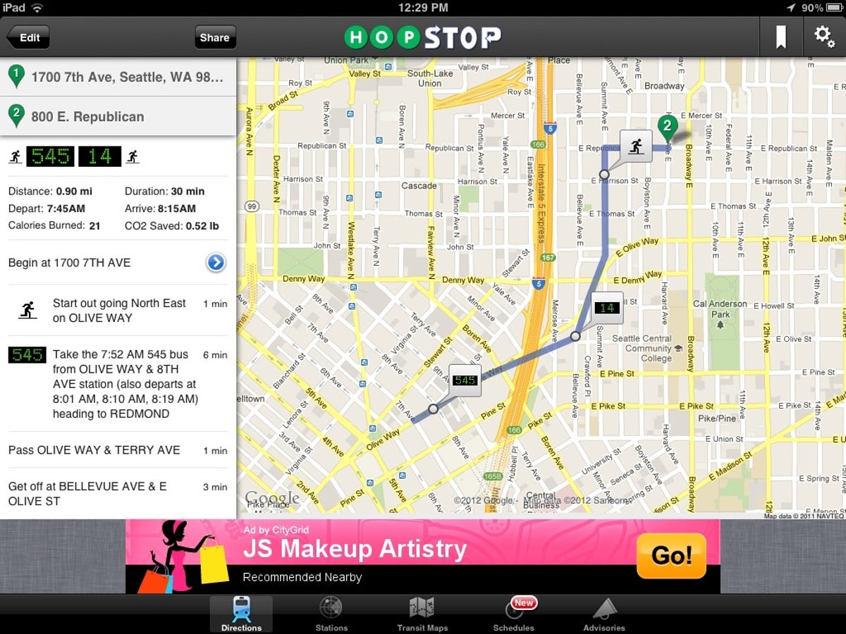
For each route HopStop indicates the distance, duration, departure and arrival times, calories burned, and CO2 saved. Some of the routes HopStop suggested seemed to entail more transfers than necessary. For example, for one route I entered the app said to catch a connector loop bus, though walking to the next stop of the route would have taken less time.
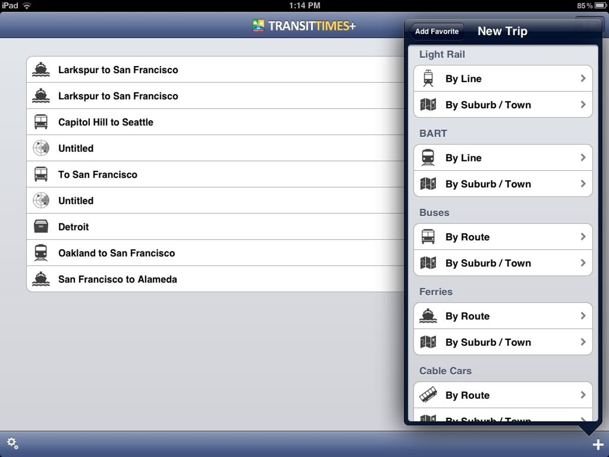
With TransitTimes+ you download the transit maps for each city you plan to visit and then select the plus sign in the bottom-right corner of the screen to add a new trip, add a stop to an existing trip, or track the next-arriving vehicle on the route.
When you create a new trip, you're asked to select the city and transit type (light rail, subway, bus, ferry, and so on) by line or by suburb or town. You then choose the starting and destination cities, followed by the departure and arrival points. A summary of the trip appears, and you're prompted to save it.
After a trip has been created, press the entry to view the next departures. Select one to see a trip summary that includes travel time and cost. Press the map icon in the bottom-right corner to view the route on a Google Map. You can also share the trip on Facebook, but not via e-mail.
I was disappointed that I couldn't choose a route by selecting the start and stop points on a map. Instead the app requires that you choose the transit type first. In many cities a trip will entail more than one means of travel, such as a bus ride and a light-rail trip.
I was also unimpressed by TransitTimes+'s real-time tracker. I can't vouch for the accuracy of the tracking, and many large metropolitan areas offer similar tracking on their own sites or via telephone. International travelers will appreciate the many overseas destinations TransitTimes+ covers, but people in the U.S. and Canada will find HopStop much easier to use.
For real-time traffic info, skip the app and stick with the site
Rarely have I had such high hopes for a free iPad app as I did for Inrix Traffic, and never have I been so disappointed. After multiple attempts to get the program to work, I finally decided to stick with the real-time traffic maps provided on Navteq's Traffic.com site.
You can either enter your home (start) address manually or use your current location as the start point, if you allowed Inrix to access the iPad's location. Then add your work address, which could also be your current location, or an address in your contact list. You can also choose the destination by searching for a business or selecting it on a map.
After you save your start and stop points, the new entry displays in the main Inrix window. Select it to view the route on a map that shows traffic tie-ups along the way in orange (slow) and red (backed up). Your estimated arrival time is shown at the top of the map, and you can send the arrival time via e-mail.

The first route I entered was mapped by Inrix with no problem, but each time I recalculated the route or attempted to map another route, the program crashed. After deleting and reinstalling the app, it would work again -- once. Every subsequent search came up snake eyes.
Several user reviews on the Inrix app's iTunes page indicate similar problems, as well as complaints that the program continues to track your location even when it isn't running. Until the bugs are worked out of this app, I'll go elsewhere for real-time traffic information.
Simple compass app delivers more than true north
When I installed the free Commander Compass Lite app from Happymagenta, I expected only to be shown north, south, east, west, and points in between. I got much more.
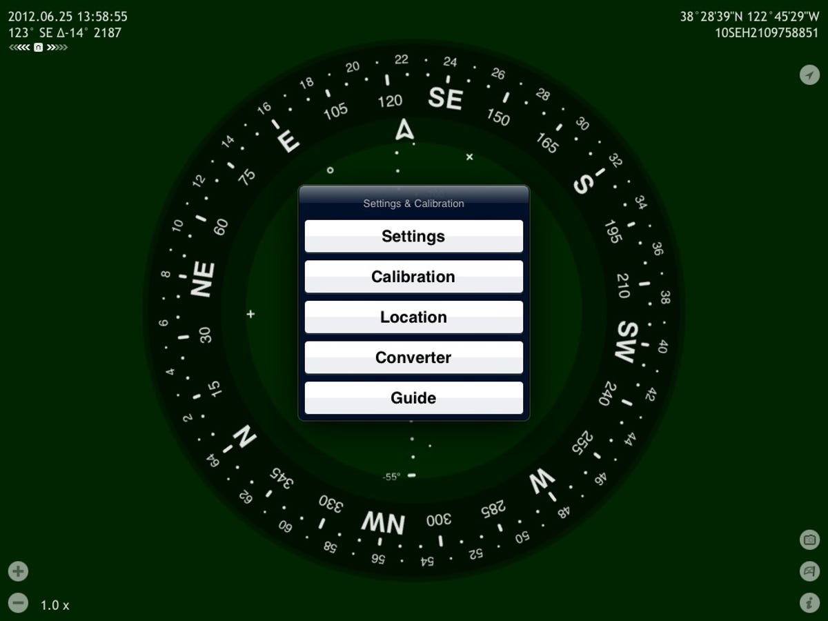
Start with your current latitude, longitude, and elevation. Add a gyroscope and gyrocompass mode, a backward-compass view, a car mode, a choice of units (metric, nautical miles, milspec), automatic coordinate conversion (degrees-minutes-seconds, Military Grid Reference System, Universal Transverse Mercator, and so on), and manual calibration.
You can use Commander Compass Lite to track destinations and bearings, hear a beep when approaching your target, and track the sun, moon, and stars. Press the Location button on the Settings & Calibration menu to view your current location on a Google Map, a satellite map, or a hybrid view.
Non-orienteers can quickly become overwhelmed by the options Commander Compass Lite provides. Fortunately, the app developer provides manuals that can be downloaded in PDF and EPUB formats. The manuals have information on the developer's popular $3.99 Spyglass "augmented reality" navigation app for iPhone and iPad.
In this case, getting more than you bargained for in a free app is a very good thing.